Forecast of impact of storm No. 5 Krathon, gusts above level 17

AN AN |

This afternoon, October 2, the meteorological agency updated the forecast of the path and impact of storm No. 5 Krathon.

Latest update from the National Center for Hydro-Meteorological Forecasting, at 2:00 p.m. on October 2, the center of the storm was located at about 21.9 degrees north latitude; 119.4 degrees east longitude, in the northeastern sea of ​​the North East Sea area.

The strongest wind near the storm center is level 14 - 15 (150 - 183 km/h), gusting over level 17; moving in a north-northeast direction, speed 5 - 10 km/h.

According to current forecasts, the storm is unlikely to affect coastal waters and mainland Vietnam.

In the next 24 hours, storm No. 5 is forecast to move northeast at a speed of about 10km/h and gradually weaken. At 1:00 p.m. on October 3, the center of the storm was at about 23.5 degrees north latitude - 120.8 degrees east longitude; in the southern area of ​​Taiwan (China).

The strongest wind near the storm center is level 11 - 12, gusting to level 15.

Updated location and path of storm Krathon at 2:00 p.m. on October 2. Source: Vietnam Disaster Monitoring System.

It is forecasted that in the next 48 hours, storm No. 5 will move northeast, at a speed of about 5 - 10 km/h, and gradually weaken into a tropical depression. At 13:00 on October 4, the center of the tropical depression will be at about 24.6 degrees north latitude - 121.5 degrees east longitude; in the area north of Taiwan Island (China).

The strongest wind near the center of the tropical depression is level 7, gusting to level 9.
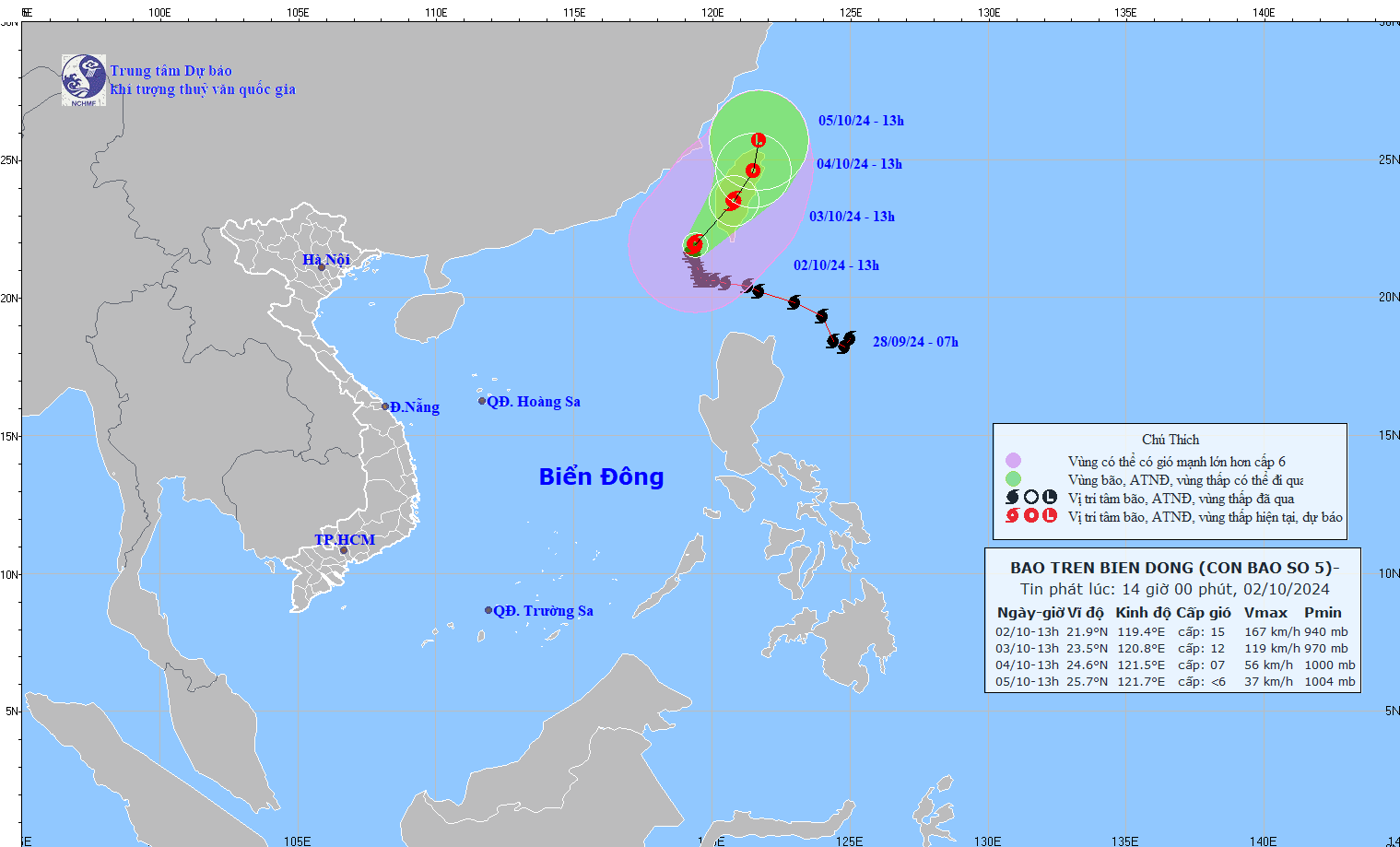
Cap nhat vi tri va duong di cua bao so 5 hoi 14h ngay 2.10. Anh: Trung tam Du bao Khi tuong Thuy van Quoc gia
Updated position and path of storm No. 5 at 2:00 p.m. on October 2. Photo: National Center for Hydro-Meteorological Forecasting

It is forecasted that in the next 72 hours, the tropical depression will move northward at a speed of about 5km/h and weaken into a low pressure area. At 13:00 on October 5, the center of the low pressure area will be at about 25.7 degrees north latitude - 121.7 degrees east longitude; in the sea north of Taiwan (China).

The strongest wind near the center of the low pressure area is below level 6.

Regarding the impact of the storm, the northeastern sea area of ​​the North East Sea (north of latitude 19.5; east of longitude 117.5) has strong winds of level 9 - 11, near the storm center level 13 - 15, gusts above level 17, waves 8 - 10m high; rough seas.

Ships operating in the above mentioned dangerous areas are affected by storms, whirlwinds, strong winds and big waves.

AN AN
RELATED NEWS

Tet returns to the flood center

|

After two historic natural disasters, the flood-stricken area of Gia Lai welcomes Binh Ngo Tet 2026 under the warm homes that have been revived rapidly. A simple Tet, but warm enough for people to feel at peace.

Vietnamese players celebrate Tet, share family moments

|

The players took advantage of the short holiday to reunite with family, visit relatives and save Tet moments with loved ones before returning to the schedule.

Hanoi Police simultaneously check alcohol concentration from the 1st day of Tet

|

Hanoi Police simultaneously launched a campaign to check alcohol concentration, strictly handle violations, and ensure traffic safety on the morning of the 1st day of Binh Ngo Tet 2026.

Son Tung M-TP, MONO and Vietnamese stars dress up to wish Tet

|

On the 1st day of Binh Ngo Tet 2026, Son Tung M-TP and MONO and his family packed up to wish Tet, spring travel, spreading the atmosphere of reunion and warmth at the beginning of the year.

Many cases of alcohol concentration violations after drinking beer to celebrate Tet

|

Ho Chi Minh City - Many cases of alcohol concentration violations on the 1st day of Tet have been recorded and fined by Ho Chi Minh City traffic police.

Dong Dang - Tra Linh expressway not yet temporarily circulated during the Lunar New Year

|

Cao Bang - Dong Dang - Tra Linh is one of the 2 expressways planned by the Ministry of Construction to organize temporary traffic.

Forecast of cold air affecting the North more strongly

NHÓM PV |

The meteorological agency said that cold air is expanding its impact area in both the North and Central regions.

Latest forecast of movement and intensity of storm No. 5 Krathon

NHÓM PV |

Storm No. 5 has weakened in intensity, currently at level 14 - 15 but winds are still gusting above level 17 and strongly impacting the North East Sea.

Typhoon No. 5 Krathon is very strong, forecast to weaken

AN AN |

Storm No. 5 Krathon is currently at level 17; it is forecasted that in the next 24 hours, the storm will gradually weaken.