
Tonight, May 27, Hanoi welcomes thunderstorms to dispel the stuffy atmosphere after a series of intense hot days. Many people call this "golden rain" to cool down when in recent days, Hanoi has been the hot spot with the highest temperature in the country.
Previously, at 9 pm on May 27, the National Center for Hydro-Meteorological Forecasting said that through monitoring on satellite images, thunderstorm and lightning positioning data and weather radar, it was discovered that the convective cloud area developed and caused thunderstorms for communes and wards such as Yen Xuan, Son Tay, Doai Phuong, Quang Oai, Co Do, Vat Lai, Phu Cat, Ha Bang, Hoa Lac, ...
After that, the convective cloud continued to develop further, causing showers and thunderstorms in the above-mentioned wards/communes and expanding to other wards/communes of Hanoi city.In thunderstorms, there is a possibility of tornadoes, lightning, hail and strong gusts of wind.
On May 28, Hanoi city will cool down compared to May 27. Hot and intense sunny days with the highest temperature of 35-37 degrees C, in some places above 37 degrees C. In the evening of May 28, there will be scattered showers and thunderstorms, locally heavy rain with the lowest temperature of 28-30 degrees C.
In addition, in the bulletin issued at 9:20 pm on May 27, the meteorological agency said that in the past 3 hours (from 6 pm to 9 pm on May 27), the area of 3 provinces Son La, Phu Tho and Thanh Hoa had moderate to heavy rain, such as the following monitoring stations: Quang Minh 60.4mm (Son La); Tien Phong 3 81.6mm, Doan Ket 63mm (Phu Tho); Trung Thuong 46mm (Thanh Hoa);...
The soil moisture model shows that some areas in the above provinces have been near saturation (over 85%) or reached saturation status.
Warning in the next 3-6 hours, the areas of Son La, Phu Tho and Thanh Hoa provinces will continue to have rain with common accumulated rainfall as follows: Son La and Thanh Hoa from 10 - 30mm, in some places over 50mm; Phu Tho from 20 - 40mm, in some places over 60mm.
Warning in the next 6 hours, there is a risk of flash floods on small rivers and streams, landslides on slopes in many communes and wards.
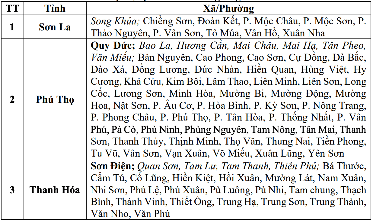
Warning level of natural disaster risk due to flash floods, landslides, subsidence due to rain, floods or currents is level 1.
Flash floods and landslides can have very negative impacts on the environment, threatening people's lives; causing local traffic congestion, affecting the movement of vehicles; destroying civil and economic works, causing damage to production activities and socio-economic activities.
The meteorological agency recommends that functional agencies in localities pay attention to reviewing flow bottlenecks and key locations in the area to have preventive and response measures.


