The winter of La Nina typically leads to higher than normal temperatures across the southern United States, drier conditions in the west, and colder weather with more typhoons in the northern part of the country.
However, in the 2024-2025 winter, weather phenomena are different from the usual developments caused by La Nina. Compared to the Northeast, Midwest and the entire Northwest Pacific, the Southeast region of the US will have colder-than-average weather. This cold front leads to a rare phenomenon: Heavy snowfall reaching the southern coast of the Gulf of Mexico. At the end of January 2025, these areas will have more than 20cm of snowfall - considered a phenomenon of "one in five years".
Typically, the El Nino phenomenon - in contrast to La Nina - will lead to snowfall in the Southeast region of the US. However, this year, cities in Tennessee Valley and the mid- Atlantic have seen above-average snowfall, similar to the years of El Nino.
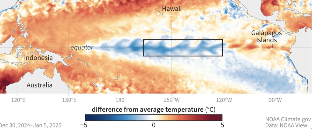
In general, this year's winter weather pattern is not typical due to the weak La Nina phenomenon. Experts predict that climate change is likely to continue to change fundamental conditions. The phenomena that were once considered typical of La Nina may no longer be true as global warming continues to change climate trends.
Forecasters are uncertain when La Nina will officially end, especially as the spring forecast barrier approaches. At this time of year, global climate models face challenges in forecasting the intensity and end time of El Nino and La Nina phenomena.
For example, last year, models predicted that the El Nino phenomenon would end quickly. However, El Nino will continue into spring and summer, leading to widespread impacts globally.
As the La Nina model weakens, weather experts are closely monitoring the future developments of the El Nino - Southern Oscillation (ENSO) phenomenon.
Fox News forecasters point out that there is a high chance of a double La Nina event - meaning a La Nina that could reappear in late 2025 or early 2026 - to the possibility of an El Nino forming.
Currently, most weather models predict a neutral state to prevail in the coming months, but uncertainty remains as a weak La Nina phenomenon is occurring.
Neutral conditions also create uncertainty for the upcoming Atlantic basin hurricane season. Neutral seasons are unpredictable, with relatively mild years with only a few tropical storms, through record-breaking years, such as 2005 with 28 named storms and 15 hurricanes.
The impact of storms in neutral years will increase on the Florida peninsula and Gulf of Mexico, similar to the impact of La Nina. The northeastern coast of the United States tends to reduce the activity of storms and tropical depressions, while the Caribo region has moderate storms and depressions.