The storm forecast bulletin of the Philippine Atmospheric, Geophysical and Astronomical Services Administration (PAGASA) said that at 1 p.m. on September 3, the center of storm Yagi (local name Enteng) was at about 18.6 degrees north latitude; 119.1 degrees east longitude, 100km west-northwest of Laoag City, Ilocos Norte, in the eastern sea area of the northern East Sea.
Typhoon Yagi strengthened on the morning of September 3, with the strongest wind near the storm's center at 85km/h (level 9), gusting to 105km/h (level 11), moving west-northwest at about 15km per hour.
The tropical storm made landfall in Casiguran, Aurora, at 2 p.m. on September 2. It then passed through Quirino, Isabela, Kalinga, Apayao and Ilocos Norte, before entering the South China Sea on the morning of September 3.
At least 14 people have died in landslides, floods and swollen rivers caused by Typhoon Yagi, the Philippines' National Disaster Risk Reduction and Management Council said.
Typhoon Yagi is expected to leave the Philippine forecast area (PAR) on Wednesday morning.
The storm is headed toward China, where it could make landfall by the weekend, according to PAGASA.
Yagi could also become a typhoon on September 5, outside the PAR. It could reach peak intensity late on September 6 or early on September 7, before making landfall in China.
Yagi is the Philippines' fifth tropical storm of 2024 and the first in September. PAGASA had previously estimated that there could be two or three tropical storms this month.
There is also a 66% chance of La Nina forming between September and November.
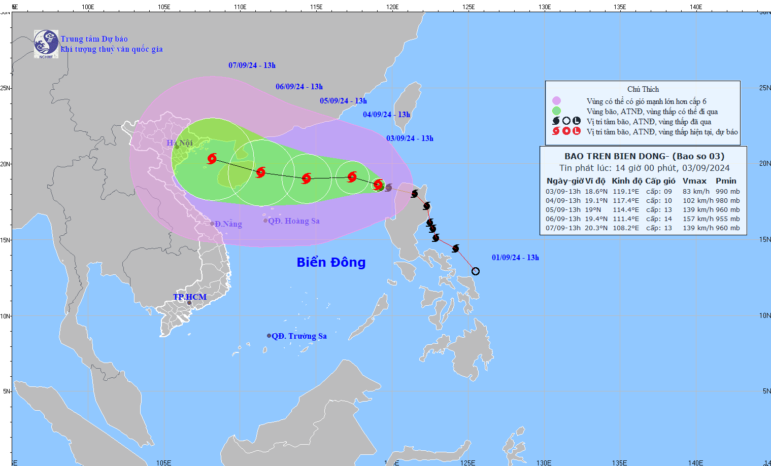
Meanwhile, according to the weather forecast at 2:00 p.m. on September 3 of the Vietnam National Center for Hydro-Meteorological Forecasting, in the next 72 to 120 hours, storm No. 3 (Yagi) will move mainly in the west-northwest direction, traveling 10-15 km per hour, with little change in intensity.
The eastern sea area of the northern East Sea has strong winds of level 8-9, the area near the storm's eye has winds of level 10-11, gusting to level 13; the sea is very rough.
It is forecasted that from the afternoon of September 4-6, storm No. 3 may reach very strong storm level in the northern sea area of the North East Sea, with strong winds reaching level 14, gusting to level 17 near the storm's center.
In the next 24 hours, the eastern sea of the northern East Sea will have waves 2-4 m high, and 3-5 m near the storm center. From the afternoon of September 4-6, they may gradually increase to 7-9 m. The sea will be rough. Ships operating in the above-mentioned dangerous areas are likely to be affected by strong winds and large waves.