Since storm No. 3 entered the East Sea with an intensity of only level 8, gusting to level 10 on September 3, by early afternoon on September 4, the storm's intensity had increased to level 12, gusting to level 15, an increase of 4 levels in just 24 hours.
According to the latest storm forecast from the Storms page in the Northwest Pacific, storm No. 3 continues to operate in a very favorable environment, so its intensity will continue to increase very quickly in the next 1-2 days, not excluding the possibility of strengthening into a super storm with winds of level 15-16, gusting over level 17 in the east of Hainan Island (China) on September 6.
Storm No. 3 formed at a terrifying speed and is undergoing a rapid intensification phase as the giant eye of the storm in the latest satellite image is nearly 50 km in diameter.
With a large, dense cloud disk and extremely strong convection, along with a sharp eye typical of a very strong storm - a super typhoon , it will be an extremely great danger to any coastal area it passes through.
The formation of an eyewall is almost always an indicator that a storm is strengthening. Right now, the right environment could make Typhoon 3 Yagi one of the strongest storms in the western Pacific basin this year.
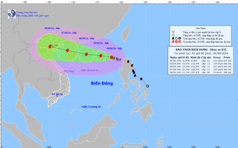
According to the latest storm information from the Vietnam National Center for Hydro-Meteorological Forecasting, at 1:00 p.m. on September 4, the center of storm No. 3 was located at about 19.1 degrees north latitude; 117.5 degrees east longitude, in the eastern sea area of the northern East Sea, about 710km east of Hainan Island (China).
The strongest wind near the storm center is level 12 (118-133 km/h), gusting to level 15, moving west-northwest at a speed of 5-10 km/h.
Forecast as of 1:00 p.m. on September 5, the center of storm No. 3 is at approximately 19.4 degrees north latitude; 115.0 degrees east longitude, approximately 430km east of Hainan Island (China). Wind force level 13-14, gust level 17.
At 1 p.m. on September 6, the center of storm No. 3 was at approximately 19.8 degrees north latitude; 111.7 degrees east longitude, in the sea northeast of Hainan Island (China). Wind force level 15, gusting above level 17.
At 1 p.m. on September 7, the center of storm No. 3 was at about 20.6 degrees north latitude; 111.7 degrees east longitude, in the Gulf of Tonkin. Wind force level 12, gust level 15.
Meanwhile, Yagi was classified as a Category 1 storm on the Safir-Simpson 5-level hurricane scale by the US Joint Typhoon Warning Center (JTWC).
The Japan Meteorological Agency (JMA) forecasts that Typhoon Yagi will reach its peak at 185 km/h, pressure 925 hPa and could challenge the record for the strongest typhoon to make landfall in Hainan (China) in history.
The Hong Kong Observatory (China) forecasts that Typhoon Yagi could reach super typhoon level with winds of 185 km/h before hitting southern China.