On September 4, implementing Official Dispatch No. 86/CD-TTg dated September 3, 2024 of the Prime Minister and in order to promptly and proactively respond to the storm, Chairman of Hai Phong City People's Committee Nguyen Van Tung issued Official Dispatch No. 05/CD-CT on urgently deploying response to Storm No. 3 in 2024 (Storm YAGI).
Accordingly, the Chairman of the Hai Phong City People's Committee requested the People's Committees of districts, departments, branches, agencies and units to absolutely not be subjective or negligent, to prepare the best conditions to proactively deploy response work according to the "four on-site" motto, not to be passive or surprised in order to ensure safety, life, and minimize property damage for people.
Strengthen information, propaganda and mobilization work for people to implement storm prevention measures, protect people and property; limit people from going out during storms and heavy rains to ensure safety. Closely monitor the storm's developments; count and notify owners of vehicles operating at sea to urgently move to safe shelters;... absolutely do not leave people on boats, rafts, and fishery watchtowers when there are strong winds or storms, especially tourists at sea and on islands; maintain regular contact with owners of vehicles to promptly handle any bad situations that may occur.
The Standing Office for Natural Disaster Prevention and Control of the City's Steering Committee for Natural Disaster Prevention, Search and Rescue and Civil Defense (Department of Agriculture and Rural Development) shall, based on the storm's developments, proactively determine the time to announce a sea ban and temporarily suspend inland waterway transport activities, river bridges, cable car systems, and entertainment areas at coastal tourist areas; proactively discuss with the Department of Transport to inform and coordinate with the Directorate for Roads of Vietnam to suspend the operation of sea bridges.
Proactively review and implement storm prevention plans, evacuation plans for people in low-lying areas, riverside, coastal areas, old and weak houses, coastal tourist areas, areas at risk of landslides and on vehicles that have arrived at anchorage. Organize inspections and implement measures to ensure the safety of dikes (especially at vulnerable locations), industrial zones, clusters, works under construction, piers, ports, etc. Review, prepare plans and organize implementation to ensure traffic safety on routes, especially in landslide areas caused by heavy rain. Maintain rescue forces and vehicles ready to respond when requested.
Request Hai Phong Maritime Port Authority and Inland Waterways Sub-Department of Region I to direct and guide ships, boats, and watercraft to anchor in waters managed by the unit to ensure safety and not affect other infrastructure works when an incident occurs.
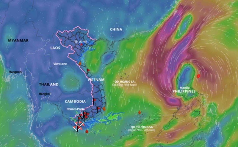
According to the National Center for Hydro-Meteorological Forecasting, at 4:00 a.m. on September 4, the eye of the storm was at about 18.9 degrees North latitude; 118.0 degrees East longitude, in the eastern sea of the North East Sea. The strongest wind near the eye of the storm was level 11 (103-117 km/h), gusting to level 13, moving in the West Northwest direction, about 10 km/h. It is forecasted that in the next 24 hours, the storm will move in the West direction, traveling 10 km per hour. At 4:00 a.m. on September 5, the eye of the storm was at about 19.2 degrees North latitude; 115.8 degrees East longitude. The strongest wind near the storm center is level 13, gusting to level 16. Disaster risk level: Level 3. Storm No. 3 is forecast to continue to strengthen, the strongest wind at sea can reach level 14, gusting to level 17 in the coming days, moving towards Hainan Island (China) and the Gulf of Tonkin, with a very high possibility of directly affecting the sea and mainland of the Northern region.