Storm news in the East Sea (storm number 3)
On the morning of September 3, Typhoon Yagi entered the northeastern sea of the North East Sea, becoming the third typhoon in 2024.
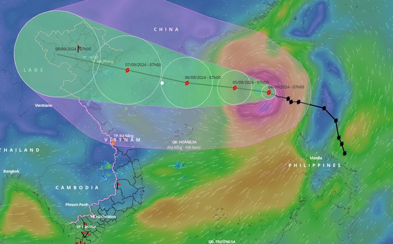
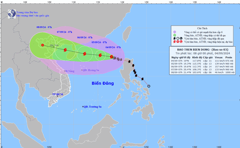
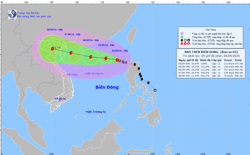
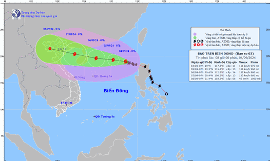
At 4:00 a.m. on September 4, the center of the storm was located at approximately 18.9 degrees North latitude; 118.0 degrees East longitude, in the eastern sea area of the northern East Sea. The strongest wind near the center of the storm was level 11, gusting to level 13, moving in the West Northwest direction, at approximately 10 km/h.
Forecast of the storm (next 24 - 72 hours), until 4:00 a.m. on September 5, position 19.2 degrees North latitude, 115.8 degrees East longitude; about 560km East of Hainan Island (China). The storm moves West, about 10km/h, wind speed level 13, gust level 16. Dangerous area north of latitude 17.0; east of longitude 114.0. Natural disaster risk level 3: East of the North East Sea area.
At 4:00 a.m. on September 6, the storm was located at 19.5 degrees North latitude, 112.8 degrees East longitude, about 230km east of Hainan Island (China); moving west, about 10 - 15km/h; wind force level 14, gust level 17. Dangerous area north of latitude 17.0; from 111.0 - 118.0 degrees East longitude.
At 4:00 a.m. on September 7, the location was at 20.3 degrees North latitude, 108.9 degrees East longitude, in the Gulf of Tonkin; moving West Northwest, about 15km/h; wind force level 13, gust level 16. Dangerous area north of latitude 18.0; from 108.5 to 116.0 degrees East longitude.
Level 4 disaster risk in the northern part of the North East Sea. Level 3 disaster risk in the Gulf of Tonkin.
The National Steering Committee for Natural Disaster Prevention and Control warned that in the next 72 to 120 hours, the storm will move mainly in the West-Northwest direction, traveling 15km per hour, with its intensity continuing to decrease.
Forecast of strong winds, high waves and thunderstorms at sea
The National Steering Committee for Natural Disaster Prevention and Control said that on the day and night of September 4, the eastern sea area of the North East Sea will have strong winds of level 8-10, near the storm center will have strong winds of level 11-13, gusts of level 16, rough seas, waves from 2.0 to 4.0 meters high, near the storm center from 4.0 to 6.0 meters high.
The sea area from Ninh Thuan to Ca Mau, the central and southern East Sea (including the sea area of Truong Sa archipelago) has strong southwest wind level 6, gusting to level 7 - 8; waves from 2.0 - 4.0m high.
In addition, on the day and night of September 4, there will be storms in the eastern sea of the North East Sea. The central and southern East Sea (including the waters of the Truong Sa archipelago), the waters from Binh Thuan to Ca Mau, Ca Mau to Kien Giang and the Gulf of Thailand will have showers and thunderstorms. During thunderstorms, there is a possibility of tornadoes and strong gusts of wind of level 7-8, beware of wave heights sometimes increasing above 2.0m.
Level of disaster risk due to strong winds at sea: level 2, eastern sea area of the North East Sea level 3.
Warning of local heavy rain, tornadoes, lightning, strong gusts of wind in the Central, Central Highlands and Southern regions
In the afternoon and evening of September 4, the Central Highlands and the South will have rain, moderate rain and scattered thunderstorms, with rainfall ranging from 20 - 40mm, locally over 70mm. The Central and South Central regions will have scattered showers and thunderstorms, with rainfall ranging from 10 - 30mm, locally over 60mm.
Thunderstorms may cause tornadoes, lightning, hail and strong gusts of wind. Localized heavy rain may cause flooding in low-lying areas; flash floods in small rivers and streams; and landslides on steep slopes.