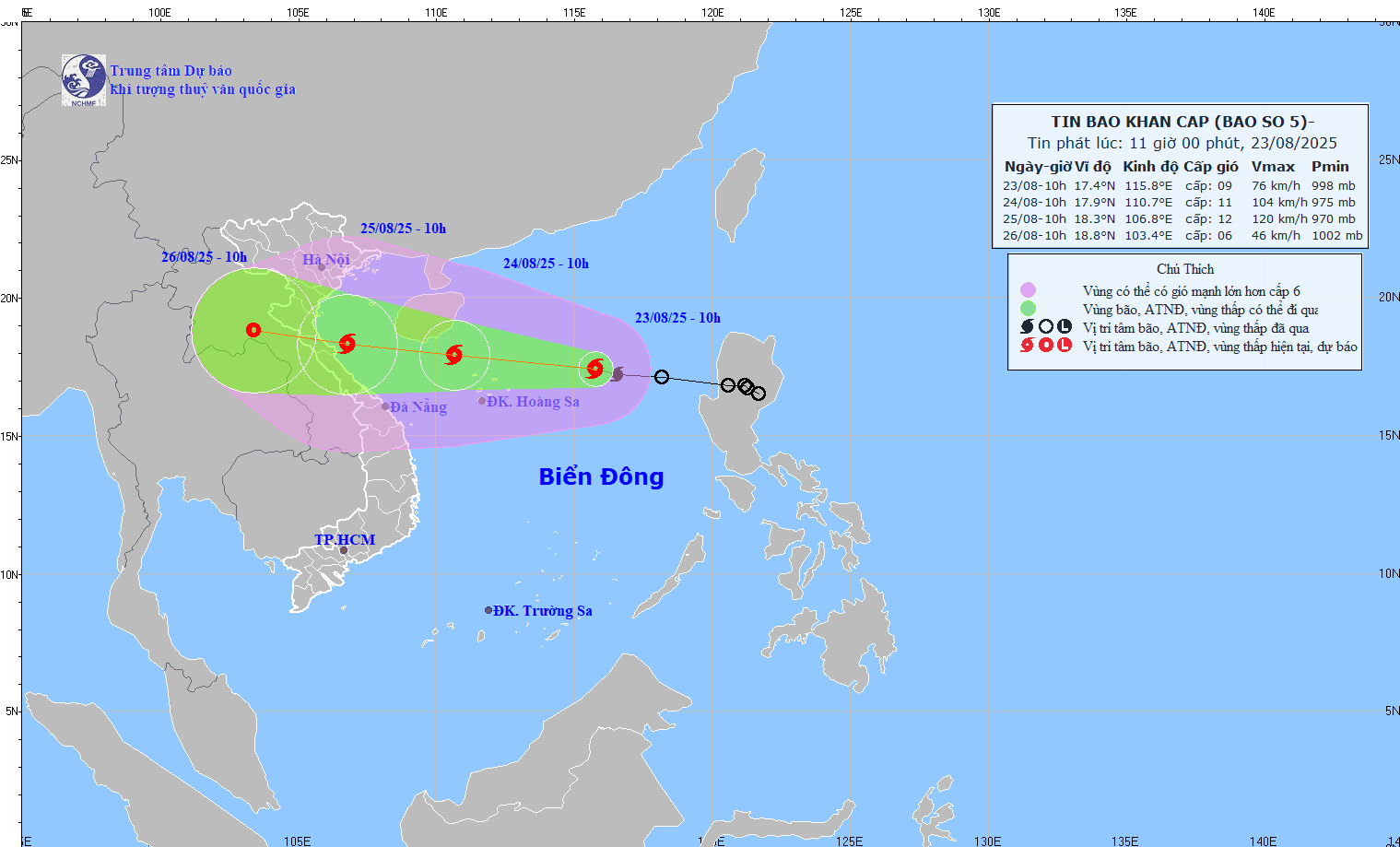
Latest update from the National Center for Hydro-Meteorological Forecasting, at 10:00 a.m. on August 23, the center of storm No. 5 was at about 17.4 degrees north latitude; 115.8 degrees east longitude, about 380 km east-northeast of Hoang Sa Special Zone. The strongest wind near the storm center is level 8 - 9 (62 - 88 km/h), gusting to level 11: moving west-northwest at a speed of about 25 km/h.
Storm No. 5 will continuously strengthen before making landfall
It is forecasted that in the next 24 hours, the storm will move west-northwest at a speed of 20 - 25 km/h and continue to strengthen.
At 10:00 on August 24, the center of the storm was at about 17.9 degrees north latitude; 110.7 degrees east longitude, in the northwest sea of Hoang Sa province. Strong wind level 10 - 11, gust level 14.
The danger zone is from 16 to 20 degrees north latitude; from longitude 109 to 118 degrees east longitude. Level 3 natural disaster risk, the affected area is the northern East Sea (including Hoang Sa special zone) and the sea off the coast of Quang Tri - Hue.
It is forecasted that in the next 48 hours, the storm will move west-northwest at a speed of about 20 km/h.
At 10:00 on August 25, the center of the storm was at about 18.3 degrees north latitude; 106.8 degrees east longitude, in the sea from Thanh Hoa to Hue. Strong wind level 11 - 12, gust level 15.
The danger zone is from 16 to 20 degrees north latitude; west of longitude 113.5 degrees east longitude. Level 3 natural disaster risk, the affected area is the northwest of the East Sea (including Hoang Sa special zone), the Gulf of Tonkin and from southern Quang Tri to Thua Thien Hue.
It is forecasted that in the next 72 hours, the storm will move west-northwest, traveling about 15 km per hour and gradually weakening into a tropical depression.
At 10:00 on August 26, the center of the tropical depression was at about 18.8 degrees north latitude; 103.4 degrees east longitude, on the mainland of Central Laos. Strong wind level 6, gust level 8.
The danger zone is from 16.5 to 20 degrees north latitude; west of the 109 degrees east longitude. Level 3 natural disaster risk, the affected area is the Gulf of Tonkin and from southern Quang Tri to Hue.
The circulation of storm No. 5 is very large, strongly affecting Thanh Hoa to Hue
Regarding the impact of the storm at sea, the northern East Sea area (including Hoang Sa special zone) has strong winds of level 8 - 9, the area near the storm's eye has level 10 - 11, gusts of level 14, waves 4 - 6 m high, the sea is very rough. From noon and afternoon of August 24, the sea area from Thanh Hoa to Hue (including Con Co and Hon Ngu specialties) will have winds gradually increasing to level 6 - 8, then increasing to level 9 - 10, near the storm's eye level 11 - 12, gusting to level 15; waves 4 - 6 m high, near the eye 6 - 8 m; the sea is very rough. From the afternoon of August 24, the sea area north of the Gulf of Tonkin (including the Bach Long Vi special zone) will have winds gradually increasing to level 6 - 7, gusting to level 9, waves 2 - 4 m high, rough seas.
Storm surge in the coastal areas of Thanh Hoa - Quang Tri has storm surge water from 0.5 - 1 m high. The water level in Sam Son (Thanh Hoa) is 3.2 - 3.6 m high, in Hon Ngu (Nghe An) is 3.3 - 3.7 m high, in Vung Ang (Ha Tinh) is 3.1 - 3.4 m high and in Cua Gianh (Quang Tri) is 1.7 - 2 m high.
High risk of flooding in low-lying coastal areas, river mouths, islands from Nghe An to northern Quang Tri.
The weather at sea and in coastal areas during the storm is extremely dangerous and unsafe for any vehicles or works operating in the dangerous area such as tourist boats, passenger ships, transport ships, cages, aquaculture areas, dykes, embankments, coastal roads. Vehicles are likely to overturn or be destroyed; flooded due to strong winds, large waves and rising sea levels.
On land, from the night of August 24, on land from Thanh Hoa to Quang Tri, the wind will gradually increase to level 7 - 9, near the storm center level 10 - 12, gusting to level 13 - 15.
Regarding heavy rain, from the night of August 24 to the end of August 26, in the northern plains of the North, southern Phu Tho and from Thanh Hoa to Hue, there is a possibility of a widespread heavy rain with common rainfall of 100 - 150 mm, some places over 250 mm; from Thanh Hoa to Quang Tri, there will be heavy to very heavy rain with common rainfall of 150 - 300 mm, some places over 600 mm.
There is a high risk of heavy rain with rainfall greater than 200 mm within 3 hours.
From August 25 to 26, the capital Hanoi and Da Nang city will have moderate rain, heavy rain and thunderstorms; Ho Chi Minh city will have rain, showers and thunderstorms in the late afternoon and evening.
During thunderstorms, it is necessary to be on guard against the risk of tornadoes and strong gusts of wind.
From August 25 to 27, the upper and middle areas of Laos are likely to experience heavy rain with a common rainfall of 100 - 250 mm, with some places in the middle Laos experiencing over 500 mm.