According to the latest weather forecast from the Philippine Atmospheric, Geophysical and Astronomical Services Administration (PAGASA), the tropical depression near the East Sea is about to officially strengthen into a storm.
The tropical depression is called Basyang. As of 10 pm tonight (local time), the center of the tropical depression is located at about 9.8 degrees North latitude - 134.3 degrees East longitude, 965 km east of the Northeast Mindanao area.
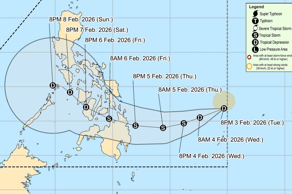
The strongest wind near the center of the tropical depression reached 55 km/h, gusting up to 70 km/h. The low pressure is moving in a West direction at a speed of 10 km/h. Strong winds extending outside the center up to 140 km.
PAGASA forecasts that the tropical depression will officially strengthen into a storm tomorrow evening 4. 2. This storm will move southwest until Thursday (February 5) before moving west and northwest throughout the remaining forecast time.
The storm will make landfall in eastern Mindanao or the southern part of Visayas on the evening of February 5th or morning of February 6th, causing widespread rain. After that, the storm will penetrate this mainland area to enter northern Palawan and enter the East Sea.
Due to the impact of a tropical depression about to strengthen into a storm, many areas in the central Philippines have strong winds and large waves over 4.5 m.
Meanwhile, in the East Sea, according to the National Center for Hydro-Meteorological Forecasting, on the night of February 3rd and February 4th, the Northern East Sea area (including the Hoang Sa special zone) has strong Northeast winds of level 6, especially the Northeast at night sometimes increases to level 7, gusts of level 8-9, strong sea waves. Wave height is commonly from 3.0 to 5.0 meters, waves in the Northeast direction.
The sea area from Khanh Hoa to Ca Mau and the sea area west of the South East Sea (including the sea area west of the Truong Sa special zone) have strong Northeast winds of level 6, gusts of level 7-8, rough seas. Waves are 2.0 to 4.0 meters high, waves in the Northeast direction.
People and tourists planning to travel to the Philippines or areas with tropical depressions should pay attention to weather forecasts. Check flight schedules and follow local instructions to avoid dangerous storms.


