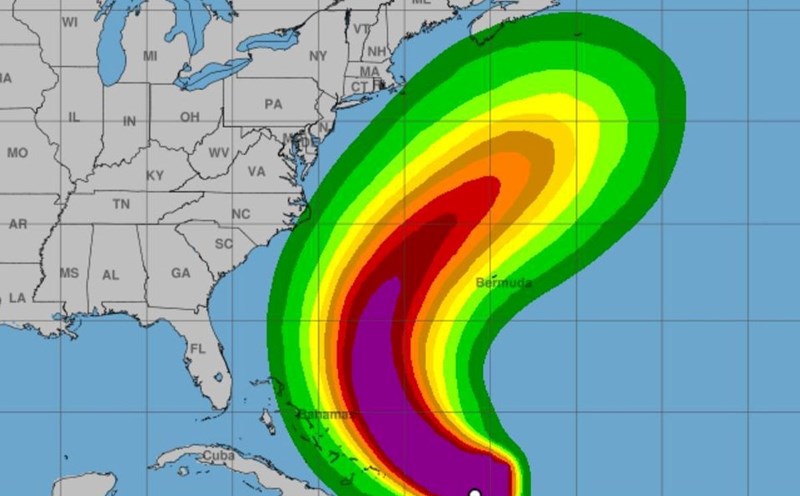
Erin currently has sustained winds of about 160 km/h. The center of the storm is about 640 km south-southeast of Cape Hatteras (North Carolina, USA) and is moving north, almost parallel to the East coast of the US.
In North Carolina, a state of emergency has been declared. Authorities have requested a mandatory evacuation of Hatteras and Ocracoke islands in the Outer Banks region, CNN reported.
Rescue operations have been urgently deployed due to bad weather affected by the storm. In Wrightsville Beach alone, more than 70 people who were caught in the offshore Current have been rescued in the past two days. Several beaches in Maryland, Virginia, Delaware, New Jersey and New York City have also issued a swimming ban until the effects of Hurricane Erin are gone.
The US National Hurricane Center (NHC) said that in the next few days, Hurricane Erin will create large waves and dangerous offshore flows on the beaches of the Bahamas, Bermuda, the East Coast of the United States and the Atlantic coast of Canada.
In the Outer Banks (North Carolina), surge water combined with large waves is expected to appear from the evening of August 20, eroding the beach, overflowing the road and cutting off some traffic routes.
In addition, coastal areas of Virginia could also see strong tropical storm winds on August 21. Bermuda is likely to be directly affected by the storm from August 21-22.
The storm's surge is forecast to reach 1-1.2 m, with waves over 6 m high, with gusts of 65-95 km/h on the evening of August 20 to the morning of August 21 (local time).
There are signs that Erin may intensify in the next 24-36 hours thanks to favorable conditions for sea temperatures and high-altitude winds.
After about 48 hours, when the wind breaks strongly, Erin will gradually weaken and may turn into a tropical depression on the fourth day of the forecast cycle.
The forecasting agency emphasized that Erin's strong wind range is much wider than average, so the actual risk of dangerous gusts may be higher than the published probability data.
Tourists in the Bahamas, Bermuda, the East Coast of the US and Canada are advised to closely monitor forecasts, limit swimming, and strictly follow evacuation instructions when ordered.


