Where is fina?
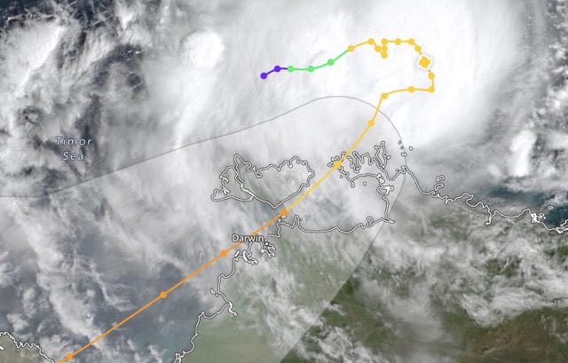
fina is strengthening again - Darwin is expected to be strongly affected from noon and evening on Saturday (November 22). Waves around the center of the storm are up to 6.4 m high, endangering all sea tourism activities and boats.
From Friday afternoon (November 21 local time), the Darwin area has begun to have heavy rain and strong winds. Some places such as Croker Island recorded more than 190 mm of rainfall overnight, with gusts of up to 120 km/h in the Cobourg peninsula.
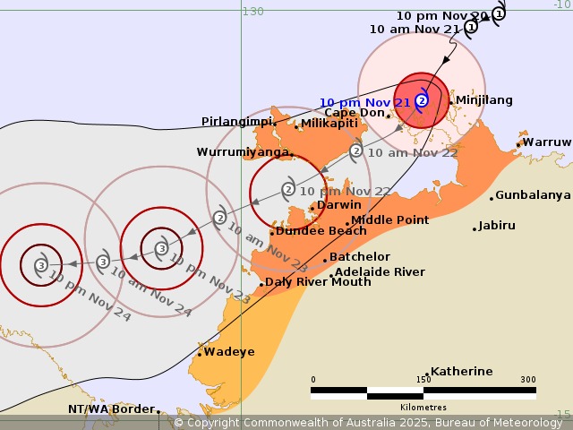
Initially weakening to Category 1, fina has re-strengthen into a Category 2 hurricane (as measured by the Australian hurricane scale) as it changes course and is expected to remain the same or strengthen further as it approaches Darwin. The city is currently completely within the warning zone.
The Australian Bureau of Meteorology (BOM) said the monitoring area had expanded. The northern coastal communities of Northern Australia, including the Tiwi Islands, have begun to feel the effects of the storm and are expected to deteriorate rapidly today and tomorrow.
According to the BOM, Darwin has had quite calm weather for the past 1-2 days, but this will change rapidly, with strong winds of about 90 km/h from Saturday morning and the possibility of increasing in the afternoon.
The BOM warned that gusts of wind could reach 155 km/h, with up to 300 mm of rainfall, accompanied by flash floods and storm surges - a danger to low coastal areas.
If the trajectory were kept intact, fina could be straight at Darwin at around 7pm on Saturday night (22.12 local time).
Northern Territory Emergency Response Force informs about the impact of fina:
shelters in Minjilang and Warruwi have opened, with residents asked to move to safety before dark.
The ferry between Darwin and the Isle of Tiwi has stopped operating.
In Darwin, shelters are not yet open but there will be clear and wide notices when they need to be activated.
On Saturday, bus services in the city were temporarily suspended, but the government did not ask businesses to close.
Important instructions for tourists affected by storm fina
Tourists are warned not to be subjective if the weather is temporarily calm, as this is a characteristic of tropical storms.
Regularly follow news from the government and updates from the BOM.
Avoid driving in flooded or overflowed conditions.
Prepare emergency equipment if staying at a hotel or rented house: drinking water, dry food, spare batteries, flashlights, medicine.
Do not go to sea, do not stand near the embankment or wharf area.
Do not open windows or stand near large glass areas when there are strong winds.
Listen to the instructions of the authorities.
Do not leave the shelter until further notice.
Clean up outdoor furniture (whether at a homestay or rented house), avoid letting items become "flying objects" in strong winds.
Reserving food for 72 hours as recommended by the government.
If you are planning to travel to the Tiwi Islands or the Top End coastal area, visitors should postpone your trip until the situation is stable.


