The unusual thing about Typhoon fina about to make landfall

Ninh Phương |

fina is forecast to make landfall in Australia. This is one of the earliest storms to appear in decades in the land of Kangaroo.

The unusual point of storm fina

fina is the first storm of the 2025 hurricane season. According to the storm forecast, fina - currently a strong Category 2 hurricane - could strengthen to Category 3 (according to the classification of storms in Australia) and affect the Northern region of Australia this weekend.

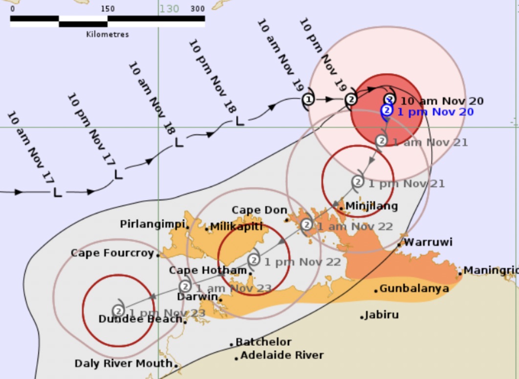
fina is forecast to sweep across the Cobourg peninsula, enter Van Diemen Bay, and then make a second landfall near Darwin or the Tiwi Islands on November 21 or 22 (local time). This is rare because the last time Australia was affected by such an early storm was in 2016.

As of the morning of November 20 (local time), fina is located about 405 km northeast of Darwin, maintaining an average wind speed of 95 km/h, gusting up to 130 km/h. After changing course overnight, the storm will begin moving south and is expected to continue approaching the Top End for the next 24 hours.

Du bao duong di va vung anh huong cua bao Fina khi do bo dat lien o phia bac Australia. Anh: BOM
Forecast of the path and area of impact of fina when it makes landfall in northern Australia. Photo: BOM

Professor Steve Turton, an expert at the University of Central Australia, said that sea surface temperatures in Timor's sea area are currently higher than average and far exceed the threshold of 26.5 degrees Celsius needed for the storm to form, allowing fina to develop faster.

fina is a small storm. Little storms often strengthen very quickly, but can also weaken quickly. This feature makes them easy to surprise tourists or locals when the storm suddenly intensifies, he said.

The reason behind fina's early appearance is the unusually warm ocean surrounding Northern Australia. Sea surface temperatures are currently at 30-31°C much higher than the 26.5°C needed to form a tropical cyclone and also higher than the common level in mid-November.

For communities in northern Australia, this means they must maintain a higher response level throughout a season of unusually strong activity.

Traditional quiet periods may be shorter, and the intensity of tropical cyclones forming this season is likely to outperform historical storms.

When will fina make landfall?

Friday (November 21): fina is likely to sweep across the Cobourg Peninsula and Croker Island with heavy rain, strong winds, and unusually high tides, according to the Australian Bureau of Meteorology (BOM).

Saturday (November 22): The storm enters Van Diemen Bay - a warm water area that could help the system strengthen again, with a small probability of reaching level 3.

weekend (23.11): The storm moves through the Clarence Strait and may squeeze north of Darwin, but some forecast models show the possibility of an closer trajectory or direct landfall.

Darwin is likely to see heavy rain and strong winds from Saturday to Sunday, even if the center of the storm does not head straight into the city. Some models show that the eye of the storm could be very close to Darwin on Saturday evening (November 22) and should be monitored closely.

After passing Darwin, fina may continue north of Kimberley (Western Australia) early next week and is likely to bring heavy rain and strong gusts here.

Risk of heavy rain, gusts of wind and flooding due to storm fina

The expected rainfall is 100-300 mm over the Top End; heavy rain can reach 500 mm.

Strong winds of 125-164 km/h (level 2, typhoon) or 165-224 km/h (if reaching level 3 - strong storm, according to the Australian typhoon scale).

Coastal areas may experience dangerous high tides as the storm approaches shore.

Tourists coming to Darwin or Tiwi during this period should closely monitor storm forecasts due to the high level of uncertainty.

If you are in coastal areas such as Tiwi, Cobourg Peninsula or near Darwin, visitors should update travel plans, limit going out during strong winds, and prepare safe shelters.

Ninh Phương
TIN LIÊN QUAN

Storm fina moves quickly, bringing heavy rain to the mainland

|

According to the latest storm forecast, the center of fina is currently located about 250km northeast of Darwin City, Australia and is moving slowly westward.

Typhoon fina intensifies to maximum intensity as it approaches land tonight

|

According to the latest storm forecast, fina - the first storm of the season in North Australia - is showing signs of intensifying as it approaches the mainland.

Weather forecast for today, November 21: Heavy rain over 200mm in the Central region, floods are still high

|

Weather forecast for today, November 21, the Central region continues to suffer from heavy rains, causing the risk of flash floods and landslides.

Storm fina is about to rapidly strengthen towards the mainland

|

According to the latest storm news, fina is forecast to strengthen back to Category 2 - possibly even reaching Category 3 from today, November 21 before making landfall in Australia.

Rescuing a Western tourist trapped on a ship for 2 days in the midst of a historic flood

|

French tourists expressed their gratitude for being helped by a female train attendant to arrive at the airport on time after 2 days stuck in the midst of a historic flood in Gia Lai.

Forecast of 2 new low pressure areas appearing near the East Sea, likely to become storms

|

It is forecasted that 2 new low pressure areas will appear near the East Sea at the end of November, with the possibility of developing into storms.

Storm fina officially formed, traveling around before making landfall

|

fina is forecast to have formed off the northern coast of Australia and intensified before making landfall.

Storm fina moves quickly, bringing heavy rain to the mainland

Ninh Phương |

According to the latest storm forecast, the center of fina is currently located about 250km northeast of Darwin City, Australia and is moving slowly westward.

Typhoon fina intensifies to maximum intensity as it approaches land tonight

Ninh Phương |

According to the latest storm forecast, fina - the first storm of the season in North Australia - is showing signs of intensifying as it approaches the mainland.

Weather forecast for today, November 21: Heavy rain over 200mm in the Central region, floods are still high

Chí Long |

Weather forecast for today, November 21, the Central region continues to suffer from heavy rains, causing the risk of flash floods and landslides.

Storm fina is about to rapidly strengthen towards the mainland

Ninh Phương |

According to the latest storm news, fina is forecast to strengthen back to Category 2 - possibly even reaching Category 3 from today, November 21 before making landfall in Australia.

Rescuing a Western tourist trapped on a ship for 2 days in the midst of a historic flood

Chí Long |

French tourists expressed their gratitude for being helped by a female train attendant to arrive at the airport on time after 2 days stuck in the midst of a historic flood in Gia Lai.

Forecast of 2 new low pressure areas appearing near the East Sea, likely to become storms

Chí Long |

It is forecasted that 2 new low pressure areas will appear near the East Sea at the end of November, with the possibility of developing into storms.

Storm fina officially formed, traveling around before making landfall

Chí Long |

fina is forecast to have formed off the northern coast of Australia and intensified before making landfall.