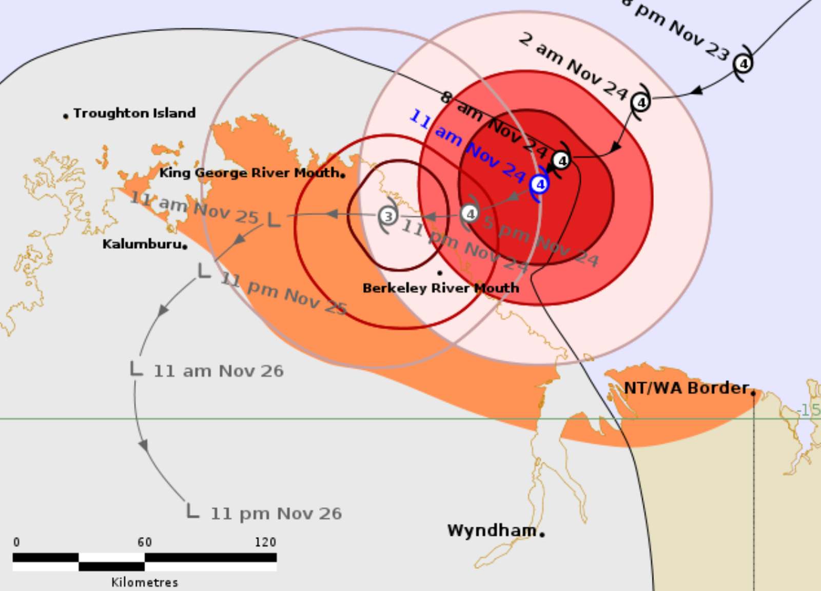
According to the Australian Bureau of Meteorology, on the night of November 23 and early this morning (local time), fina has strengthened to Category 4 ( wind speed 195-205 km/h), with gusts of up to 260 km/h. The storm affected the northeastern part of the Kimberley coast, near the state border. The storm is about 60 km northeast of the Berkeley River mouth and 160 km east of the Kalumburu.
The storm moved slowly at a speed of 6km/h southwest, across the southern part of Joseph Bonaparte Bay, after moving out of Darwin and the Northern continental coast over the weekend.
fina is forecast to cross the West Coast of Australia, between the King George River mouth and the Berkeley River mouth this afternoon and evening.
fina brought extremely strong winds and localized heavy rains, which could cause flash flooding along the northeastern coast of Kimberley.
As of 7:00 a.m. on November 24 (local time), fina was located about 343 km west-southwest of Darwin City (Australia) and had been moving west-southwest at a speed of about 7 km/h. The largest wave height recorded was 9.1 m.
The storm is forecast to make landfall in the next 12 hours, under the impact of the western edge of the subtropical high pressure mass located to the Southeast. After that, the storm gradually weakened to level 3 due to dry air intrusion.
When it completely made landfall near the mouth of the Berkeley River, fina continued to weaken due to interaction with terrain, becoming a tropical depression.
fina is forecast to move inland over the next two days, making landfall in North Australia. The strongest wind near the center of the storm is currently reaching 55 km/h.
People in the far northern part of Western Australia are advised to seek immediate shelter as fina approaches land.
The Western Australian Emergency Management Agency has issued an emergency warning to Cambridge Bay in northern Faraway Bay that the storm could threaten human life and homes.
A hurricane warning is being applied to the western part of Faraway Bay to the eastern part of Governor's Peninsula, north of Oombulgurri and northwestern areas of Cambridge Bay, and people are advised to prepare for the storm's impacts.
People in Beadell, the western part of the Governor Peninsula to Throughton Island and the southeastern areas of Cambridge Bay to the border with Western Australia and the Northern Territory are advised to monitor the weather.
Tourists planning to visit the above areas should monitor weather forecasts. Check flight schedules and consider routes so that storms do not cause danger.


