Forecast of the possibility of low pressure near the East Sea becoming storm No. 15, bad weather

Chí Long |

The low pressure near the Philippines is forecast to strengthen into a tropical depression in the next 24 hours, likely to become storm Verbena - the predecessor of storm No. 15 in the East Sea.

According to the latest weather forecast from the Philippine Atmospheric, Geophysical and Astronomical Services Administration (PAGASA), a low pressure is strengthening near the East Sea, within the country's responsibility area.

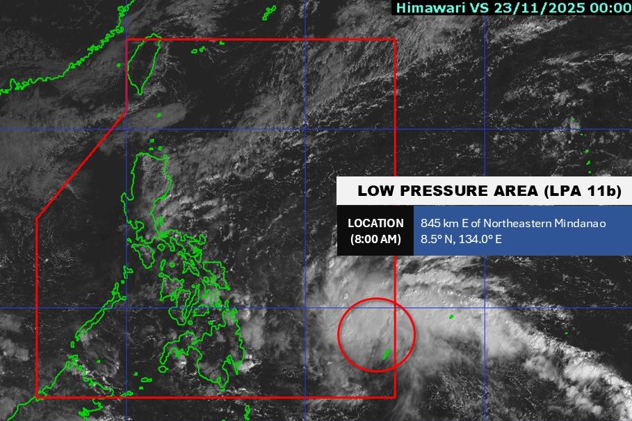
As of 8:00 a.m. this morning (local time), the center of the low pressure was at about 8.5 degrees North latitude - 134.0 degrees East longitude, about 845 km East Northeast of Mindanao. The strongest wind near the center of the low pressure reaches 30 km/h. The low pressure is forecast to have a high probability of developing into a tropical depression in the next 24 hours.

Cap nhat vi tri cua ap thap gan Bien Dong. Anh: PAGASA
Updated location of the low pressure near the East Sea. Photo: PAGASA

PAGASA forecasts that the low pressure will continue to strengthen and develop into a tropical storm when it enters the East Sea next week. If it enters the East Sea, it will be the 15th storm to make landfall in the region this year.

According to the National Center for Hydro-Meteorological Forecasting, currently, in the North East Sea area, there are strong Northeast winds of level 6, sometimes level 7, gusting to level 8-9.

The North East Sea area (including Hoang Sa special zone) has Northeast winds of level 6, sometimes level 7, gusting to level 8-9. Strong sea; waves 3.0-5.0m high.

From South Quang Tri to Ca Mau and the northern sea area of the Central East Sea: Northeast wind level 5, sometimes level 6, gusting to level 7-8. Rough seas; Waves 2.0-4.0m high.

The sea area west of the Central East Sea, the South East Sea (including Truong Sa special zone), the sea area from South Quang Tri to Ca Mau, Ca Mau to An Giang and the south of the Gulf of Thailand will have scattered showers and thunderstorms. During thunderstorms, there is a possibility of tornadoes and strong gusts of wind.

It is forecasted that during the day and night of November 24, the North East Sea area (including Hoang Sa special area) will have strong northeast winds of level 6, sometimes level 7, gusting to level 8-9; from the evening and night, it will strengthen to level 7, gusting to level 9-10, waves 3.0-5.0m high, then increase to 4.0-6.0m, rough seas.

In the afternoon and night of November 24, the Gulf of Tonkin will have northeast winds gradually increasing to level 6, gusting to level 7-8, waves 2.0-4.0m high.

From the evening and night of November 24, the Central East Sea area will have strong northeast winds of level 6, sometimes level 7, gusting to level 8-9, waves 3.0-5.0m high, rough seas.

The sea area from South Quang Tri to Ca Mau and the western sea area of the South China Sea (including the western part of Truong Sa special zone) will have northeast winds gradually increasing to level 6, sometimes level 7, gusting to level 8-9, waves 2.0-5.0m high, rough seas.

People and tourists planning to visit these coastal areas should pay attention to weather forecasts. Follow local instructions to avoid storms and large waves at sea that are dangerous.

Chí Long
TIN LIÊN QUAN

Storm fina makes landfall with destructive winds, thousands of households lose power

|

fina made landfall in northern Australia on the night of November 22, uprooting trees and traffic lights, and causing power outages for thousands of households.

New cold air mass strengthens, the coldest weather in the North is below 10 degrees Celsius

|

The cold air is forecast to cause the temperature to drop, the Central region will have widespread heavy rain.

Weather forecast for today, November 23: Heavy rain in the Central region, floods above level 3

|

Weather forecast for today, November 23, heavy rain continues in the Central region, locally over 250mm.

Forecast of when the East Sea will welcome a new storm or tropical depression

|

The weather forecast for the East Sea is likely to have one to two storms or tropical depressions from now until the end of December.

Storm fina maintains destructive winds and heavy rain inland

|

Storm fina is forecast to be strong at level 3, continuing to directly affect the Darwin region (Australia) with strong gusts of wind and heavy rainfall.

Forecast of 2 new low pressure areas appearing near the East Sea, likely to become storms

|

It is forecasted that 2 new low pressure areas will appear near the East Sea at the end of November, with the possibility of developing into storms.

Storm fina makes landfall with destructive winds, thousands of households lose power

Chí Long |

fina made landfall in northern Australia on the night of November 22, uprooting trees and traffic lights, and causing power outages for thousands of households.

New cold air mass strengthens, the coldest weather in the North is below 10 degrees Celsius

Chí Long |

The cold air is forecast to cause the temperature to drop, the Central region will have widespread heavy rain.

Weather forecast for today, November 23: Heavy rain in the Central region, floods above level 3

Chí Long |

Weather forecast for today, November 23, heavy rain continues in the Central region, locally over 250mm.

Forecast of when the East Sea will welcome a new storm or tropical depression

Ninh Phương |

The weather forecast for the East Sea is likely to have one to two storms or tropical depressions from now until the end of December.

Storm fina maintains destructive winds and heavy rain inland

Chí Long |

Storm fina is forecast to be strong at level 3, continuing to directly affect the Darwin region (Australia) with strong gusts of wind and heavy rainfall.

Forecast of 2 new low pressure areas appearing near the East Sea, likely to become storms

Chí Long |

It is forecasted that 2 new low pressure areas will appear near the East Sea at the end of November, with the possibility of developing into storms.