Central region to experience heavy rain due to storm No. 15

Chí Long |

The tropical depression near the East Sea is forecast to strengthen into a storm in the next 2 days, becoming storm No. 15 heading towards the South Central region.

According to a new weather forecast from the National Center for Hydro-Meteorological Forecasting, on the morning of November 24, a tropical depression is active in the sea east of the central Philippines.

At 8:00 a.m., the center of the tropical depression was at about 9.5 degrees North latitude - 127.8 degrees East longitude, within the Philippine Area of Responsibility.

The strongest wind near the center of the low pressure area is level 7, gusting to level 9. The tropical depression is moving in a West-Northwest direction at a speed of about 20km/h.

The tropical depression is forecast to enter the East Sea around the night of November 25 and the morning of November 26. The tropical depression is forecast to strengthen into a storm, with maximum intensity reaching level 10, gusting to level 13 when passing through the North of Truong Sa archipelago, about 1,000km from the South Central mainland.

Cap nhat vi tri cua ap thap nhiet doi gan Bien Dong sap manh len thanh bao huong vao mien Trung. Anh: Trung tam Du bao Khi tuong Thuy van quoc gia
Updated location of the tropical depression near the East Sea about to strengthen into a storm heading towards the South Central region. Photo: National Center for Hydro-Meteorological Forecasting

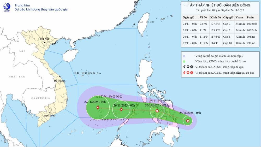
At 7:00 a.m. on November 26, the storm moved west at a speed of about 20-25 km/h. The center of the storm is located at about 11.2 degrees North latitude - 117.6 degrees East longitude, in the southeastern sea area of the Central East Sea.

After that, the storm is forecast to continue moving westward, moving towards the South Central region.

If the tropical depression strengthens into a storm, it will be the 15th storm to make landfall in the East Sea this year.

The storm mainly affected provinces from Gia Lai to Lam Dong (old Binh Dinh - Binh Thuan area), from November 28 to 30.

The meteorological agency noted that when the storm approaches the sea near the shore, it may weaken due to the impact of cold air and low sea surface temperatures in the South Central region. Therefore, when entering the mainland, the intensity is likely to be only level 8-9 storms or decrease to tropical depressions.

However, from November 28 to 30, widespread heavy rain is expected to appear in the area from Da Nang to Lam Dong, in which the coastal strip is likely to experience heavier rain than other places.

Ship operating in the above-mentioned dangerous areas are likely to be affected by thunderstorms, whirlwinds, strong winds, and large waves.

People and tourists to the Central region, especially the South Central region, should consider their schedule during this time. Continuous heavy rain can cause floods, inundation, and landslides. Tuan followed the local instructions to avoid danger during the trip.

Chí Long
TIN LIÊN QUAN

Forecast of provinces and cities most affected by storm No. 15

|

Storm No. 15 is forecast to affect the weather in coastal provinces and cities from Quang Tri to An Giang.

Tropical depression Verbena makes landfall, widespread rain

|

The tropical depression forecast near the East Sea has made landfall in the Philippines this afternoon, November 24.

Storm fina strengthens to level 4, gusts of over 260 km/h before making landfall

|

fina is forecast to approach the far North of Western Australia, making landfall today, November 24.

Storm No. 15 forecast to enter the East Sea in the next 48 hours, heading towards the mainland of Vietnam

|

According to the latest storm news, the tropical depression has officially formed off the coast of the Philippines. Tropical depression is forecast to become storm No. 15 entering the East Sea.

Super typhoon fina with gusts of 260km/h, bringing record rain to land

|

Tropical storm fina has reached its peak intensity, reaching Category 4 as it moves towards the coast of Kimberley, Australia on the morning of November 24.

Forecast of the first landing area of the predecessor of storm No. 15

|

The new low pressure is forecast to quickly strengthen into a tropical depression in 24 hours - not excluding the possibility of becoming a potential storm No. 15.

Forecast of provinces and cities most affected by storm No. 15

Chí Long |

Storm No. 15 is forecast to affect the weather in coastal provinces and cities from Quang Tri to An Giang.

Tropical depression Verbena makes landfall, widespread rain

Chí Long |

The tropical depression forecast near the East Sea has made landfall in the Philippines this afternoon, November 24.

Storm fina strengthens to level 4, gusts of over 260 km/h before making landfall

Chí Long |

fina is forecast to approach the far North of Western Australia, making landfall today, November 24.

Storm No. 15 forecast to enter the East Sea in the next 48 hours, heading towards the mainland of Vietnam

Ninh Phương |

According to the latest storm news, the tropical depression has officially formed off the coast of the Philippines. Tropical depression is forecast to become storm No. 15 entering the East Sea.

Super typhoon fina with gusts of 260km/h, bringing record rain to land

Ninh Phương |

Tropical storm fina has reached its peak intensity, reaching Category 4 as it moves towards the coast of Kimberley, Australia on the morning of November 24.

Forecast of the first landing area of the predecessor of storm No. 15

Ninh Phương |

The new low pressure is forecast to quickly strengthen into a tropical depression in 24 hours - not excluding the possibility of becoming a potential storm No. 15.