According to the latest storm information from the Philippine Atmospheric, Geophysical and Astronomical Services Administration (PAGASA), the newly formed low pressure quickly entered the country's responsibility area (PAR) on November 23.
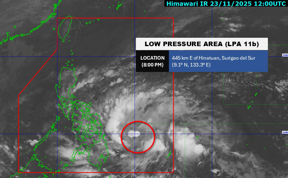
As of 8:00 p.m. on the same day, the low pressure was at about 9.1 degrees North latitude - 133.3 degrees East longitude, about 445km from Hinatuan (Surigao del Sur).
The low pressure was previously determined to be about 1,200km southeast of Mindanao when it first formed in the early morning of November 23.
The possibility of this system strengthening into a tropical depression in the next 24 hours is clearly increasing, and if it increases in intensity, it will be locally named Verbena.
PAGASA also does not rule out the possibility of the system continuing to develop into a storm when moving into the East Sea after sweeping across the Philippine mainland. At this time, the East Sea will officially welcome storm No. 15.
The forecast shows that tropical depression/depression Verbena will move west-northwest, moving into northeastern Mindanao before making landfall in the Visayas and heading north of Palawan from the afternoon of November 24 to the end of Wednesday (November 26).
The Joint Typhoon Warning Center (JWTC) recorded maximum sustained winds near the center of the depression at about 25-35 km/h.
International forecast models generally agree that the low pressure will continue to maintain its intensity slowly in the next 36-48 hours as it moves across the Philippines, and is likely to develop much stronger as it enters the East Sea.
Rain has begun to increase in Visayas and Mindanao, especially in the eastern region. From 24 November, the rain will expand to Palawan, Southern Luzon and many places in Mindanao.
When the low pressure/tropical depression reaches the Philippine mainland, the entire Visayas, Southern Luzon and part of Mindanao are forecast to have heavy to very heavy rains (100-200 mm).
It is forecasted that until November 26 - 27, the tropical depression will continue to pass through Visayas, north of Palawan and officially enter the East Sea, where it may strengthen further.
Although the wind intensity of the low pressure/tropical depression may not be too strong, heavy rainfall of up to 200mm is the main risk. Similarly, the weather could continue to worsen before the formation of Typhoon No. 15.
Tourists planning to visit the Philippines at the end of November should continuously monitor weather reports, postpone or adjust their schedules when the sea is rough.
The Southern Hydrometeorological Station forecasts that between November 26 and 27, there is also a possibility of the formation of tropical cyclones (storm or tropical depression) in the East Sea.
According to the National Center for Hydro-Meteorological Forecasting, in the period of November 21-20, December 2025, the East Sea area is likely to experience 1-2 storms or tropical depressions. Some may directly affect the mainland of Vietnam.
On average, in many years, the East Sea usually has about 1.2 storms/tropical depressions at the same time, with 0.4 of them making landfall in our country.


