According to the latest storm information from the Joint Typhoon Warning Center (JTWC), on the morning of December 22, the center of tropical storm 09S was located 587 km east of Cocos Islands.
In the past 6 hours, the storm has been moving west-northwest at a speed of about 7 km/h. The strongest wind near the center of the storm reached 75 km/h. The maximum wave height is 6.1 m.
The storm will continue to move slowly as the West moves and continue to strengthen.
It is forecasted that in the next 3 days, the storm will continuously strengthen into a very strong storm, with the strongest wind near the storm center reaching 110 km/h.
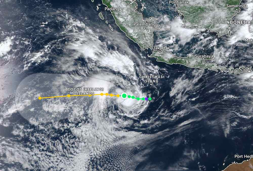
The storm is likely to make landfall or approach the Cocos Islands on Christmas Day (December 24). At that time, the wind intensity will also reach its peak, which can reach 155 km/h, giving it a typhoon status.
Due to the impact of the storm, the Cocos Islands, Northern Australia will have continuous showers. Heavy rain is likely to occur between the Christmas and New Year holidays, causing flooding in some low-lying areas. Tourists planning to enjoy their vacations in these areas should pay close attention to local weather forecasts.
Meanwhile, in the East Sea, according to the National Center for Hydro-Meteorological Forecasting, the North East Sea area has strong northeast winds of level 6-7; Ly Son station and Huyen Tran station have strong northeast winds of level 5, sometimes level 6.
Day and night of December 22, the North East Sea area (including Hoang Sa special zone): strong northeast wind level 6, especially in the East level 7, gusting to level 8-9, gusting to level 89; rough seas, waves from 4.0-6.0m high. The North of the Central East Sea will have strong northeast winds of level 6, gusting to level 7-8; rough seas, waves from 3.0-5.0m high. At night the wind gradually decreases.
The sea area from Gia Lai to Ca Mau and the western sea area of the South China Sea (including the western sea area of Truong Sa) will have strong northeast winds of level 6, gusting to level 7-8; rough seas, waves from 2.0-4.0m high.
In addition, during the day and night of December 22, the Central and South East Sea, including the Truong Sa special zone, will have scattered showers and thunderstorms.During thunderstorms, there is a possibility of tornadoes and strong gusts of wind.
Day and night of December 23, the sea area north of the North East Sea will have strong northeast winds of level 6, sometimes level 7, gusting to level 8-9, rough seas, waves 3.0-5.0m high; the sea area from Khanh Hoa to Ca Mau and the sea area west of the South East Sea (including the sea area west of Truong Sa) will have strong northeast winds of level 5, sometimes level 6, gusting to level 7-8, rough seas, waves 2.0-4.0m high.
People and tourists planning to visit these coastal areas should pay attention to weather forecasts. Tuan follows the instructions of local authorities to avoid storms and large waves at sea that are dangerous.


