The Philippine Atmospheric, Geophysical and Astronomical Services Administration (Pagasa) said that a low pressure area in the Philippine area of responsibility is likely to develop into a tropical depression within the next 24 hours.
When it becomes a weak storm in the PAR region, it will be named Auring and become the number 1 storm of the 2025 typhoon season in the Philippines.
At 2:00 p.m. on June 12 (local time), the low pressure was located about 180 km north of Batanes, at about 22.4 degrees North latitude - 121.8 degrees East longitude.
Pagasa weather expert Grace Castañeda said that this potential tropical depression will not stay in the PAR area long and may also dissipate within the next 48 hours. Auring is forecast to head towards Taiwan (China), but currently affects the Batanes and Cagayan regions of the Philippines.
The low pressure will cause heavy rain, accompanied by the risk of flooding and landslides in some areas of the northern Philippines.
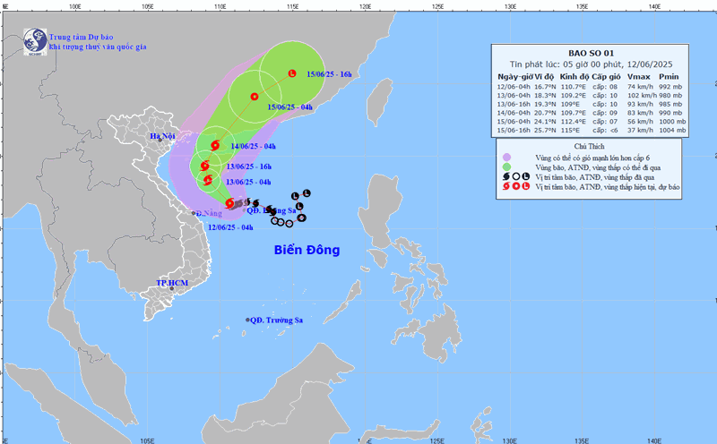
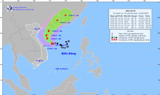
Meanwhile, Vietnam's storm No. 1 of the 2025 typhoon season (international name: Wutip) is moving towards Hainan Island (China). Intensity level 9, gust level 11.
Storm No. 1 Wutip is forecast to continue moving in the West Northwest direction, at a speed of about 5-10km.
By the afternoon of June 13, the center of the storm was at about 18.9 degrees North latitude - 108.8 degrees East longitude in the area southwest of Hainan Island.
It then made landfall in the southwestern part of Guangdong province (China) and weakened into a low pressure area in the southern mainland of China.
Strong winds and large waves are forecast at sea due to the impact of the storm.
In the Northwest of the East Sea (including the Hoang Sa archipelago) and off the coast of Quang Tri - Quang Ngai, winds of level 6-8, near the storm center level 9-10, gusting to level 13. Waves are 3-5m high, near the center of the storm 4-6m. The sea is very rough.
The Gulf of Tonkin has strong winds of level 6-7, near the storm's eye level 8-9, gusting to level 11. Waves are 2-4m high. The sea is very rough.
From Hai Phong to Nghe An, the sea level rose abnormally as at Hon Dau (3.9m); Hon Ngu (2.8m). People and tourists need to be vigilant against the risk of flooding in coastal low-lying areas and river mouths from 5pm to 7pm on June 12 and 13.
Fishing vessels, tourist boats, and watercraft in rough seas are advised not to go to sea or seek shelter, anchor safely to avoid unfortunate damage.
Visitors should also temporarily postpone recreation activities, beach activities, diving or traveling in dangerous areas, often with flash floods and landslides.
Always prepare all the necessities, medicine, batteries, lights, food, drinking water... to proactively respond to the impacts of storm No. 1 Wutip. Keep in touch; update information from the government and official media channels.