According to the latest storm information from the Philippine Atmospheric and Geophysical Agency (PAGASA), tropical depression Ramil (local name) is moving rapidly westward over the Philippine Sea and is likely to strengthen in the coming hours.
At 10:00 p.m. on October 17 (local time), the center of tropical depression Ramil was about 445 km east of Juban (Sorsogon province).
The tropical depression is moving westward at a speed of 30 km/h, doubling compared to 3 hours before. Maximum winds near the center reach 55 km/h, gusting up to 70 km/h.
Currently, some areas of Luzon and Visayas have been placed under Wind Signal Warning No. 1.
PAGASA forecasts that the highest warning level during the storm's passing may be Wind Signal No. 2, but in the worst case scenario, the affected area may be raised to Wind Signal No. 3, if the tropical depression strengthens into a severe tropical storm before making landfall.
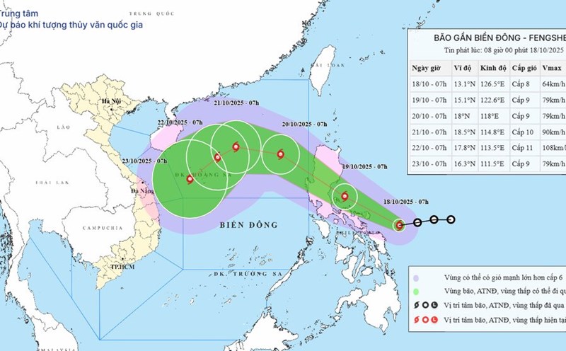
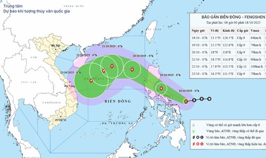
Tropical Depression Ramil is forecast to make landfall on Catanduanes Island in the afternoon or evening of Saturday (18.10).
The storm could then continue moving inland, affecting Aurora or Quezon on Sunday morning (October 19), then pass through the mountainous terrain of Northern and Central Luzon.
The storm is forecast to enter the South China Sea on Sunday afternoon or evening and leave the Philippine area of responsibility on Monday morning (October 20).
At this time, the storm officially became the 12th storm of the 2025 storm season in the East Sea.
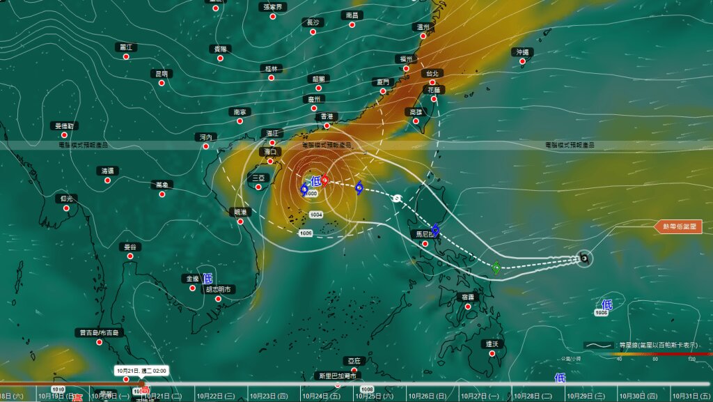
Meanwhile, the Hong Kong Observatory (China) said the tropical depression will strengthen into a tropical storm with the international name Fengshen and will approach Luzon this weekend, then move northwest of the East Sea and approach Hong Kong (China) early next week.
However, a strong cold front could cause Typhoon No. 12 to suddenly change direction to 90 degrees southwest and weaken from Wednesday (October 22).
The time of weakening and the direction of storm No. 12 is still uncertain, people and tourists are advised to closely monitor weather forecasts.
Tourists planning to visit Luzon or the central Philippine islands in the coming days should closely monitor weather reports and announcements from airlines, as some domestic flights and ferries may be delayed or canceled due to bad weather.
Tourists should move their schedules to these destinations after the storm passes, or choose areas south of the Philippines - less directly affected by storm No. 12.