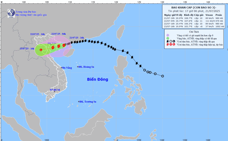
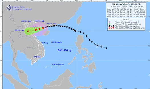
According to the National Center for Hydro-Meteorological Forecasting, at 7:00 a.m. on July 22, the center of the storm was at about 20.2 degrees North latitude - 106.7 degrees East longitude, in the coastal waters of Hai Phong - Ninh Binh.
The strongest wind near the storm center is level 9 (75-88km/h), gusting to level 12. Storm Wipha is moving in a West-Southwest direction at a speed of about 15km/h.
Due to the impact of storm No. 3, in Bach Long Vi special area, there were strong winds of level 10, gusting to level 12; Co To special area had strong winds of level 8, gusting to level 11; Cat Ba (special to Cat Hai area) had strong winds of level 6, gusting to level 8.
Cua Ong area has strong winds of level 9, gusts of level 12; Bai Chay has strong winds of level 8, gusts of level 9; Quang Ha has strong winds of level 8; Tien Yen has strong winds of level 7, gusts of level 9. Thai Binh station has strong winds of level 7, gusting to level 8; Mong Cai has strong winds of level 6, gusting to level 9; Phu Lien has strong winds of level 6, gusting to level 8...
In the plains and coastal areas of the North, Thanh Hoa, Nghe An, there will be moderate rain, heavy rain, some places will have very heavy rain with common rainfall of 70-150mm, some places over 200mm.
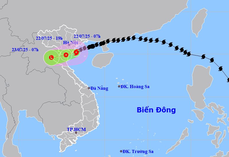
It is forecasted that by 7:00 p.m. on July 22, storm No. 3 Wipha will move in a West-Southwest direction at a speed of 10-15km/h and gradually weaken into a tropical depression. The center of the low pressure is located at about 19.9 degrees North latitude - 105.5 degrees East longitude, on land from Hai Phong to Thanh Hoa level 6, gusting to level 8.
Natural disaster risk level: Level 3, for the Gulf of Tonkin, coastal waters and mainland provinces from Quang Ninh to Thanh Hoa.
At 7:00 a.m. on July 23, the low pressure moved in the West Southwest direction at a speed of about 10-15km/h and gradually weakened into a low pressure area. The center of the low pressure is located at about 19.6 degrees North latitude -103.8 degrees East longitude, in the Upper Laos area.
Due to the influence of storm No. 3, the northern sea area of the Gulf of Tonkin (including the special areas of Bach Long Vi, Co To, Van Don, Cat Hai, Hon Dau island) has strong winds of level 6-7, near the storm's eye level 8-9, gusts of level 12; waves 2.0-4.0m high, near the storm's eye 3.0-5.0m; very rough seas.
The southern Gulf of Tonkin (including Hon Ngu Island) has strong winds of level 6-7, near the storm center level 8, gusts of level 11. The waves are 2.0-4.0m high; the sea is rough.
The coastal area of Hung Yen - Quang Ninh has storm surge of 0.5-1.0m high. The water level in Ba Lat (Hung Yen) is 2.64-2m high, Hon Dau (Hai Phong) is 3.9-4.1m high, Cua Ong (Quang Ninh) is 4.6-5.0m high and Tra Co (Quang Ninh) is 3.6-4.0m high. High risk of causation.
From July 22 to July 23, in the Northern Delta, Thanh Hoa and Nghe An, there will be heavy to very heavy rain and thunderstorms with common rainfall of 100-200mm, locally over 300mm.
Other places in the Northern region and Ha Tinh will have moderate rain, heavy rain, locally very heavy rain and thunderstorms with common rainfall of 50-100mm, locally over 150mm.
Warning of the risk of heavy rain (over 150mm/3 hours). Heavy rainfall in a short period of time can cause flash floods, landslides in mountainous areas, and flooding in low-lying areas.
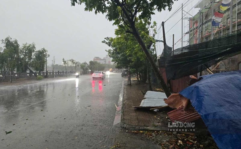
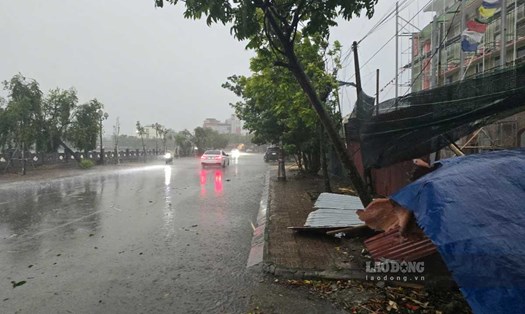
The weather at sea and in coastal mainland areas during the storm is extremely dangerous and unsafe for any vehicles or works operating in the danger zone.
On land, coastal areas from Quang Ninh to Nghe An will have strong winds of level 6-7, near the storm center level 8-9, gusting to level 12.
The deep inland areas of Hai Phong, Hung Yen, Bac Ninh, Hanoi, Ninh Binh and Thanh Hoa provinces/cities have strong winds of level 6, gusting to level 7-8. Level 9 winds can break tree branches and blow off roofs, causing damage to houses.
People and tourists should not participate in any sea or river journey in the next 3 days. Avoid going out during thunderstorms and follow local recommendations to ensure safety.