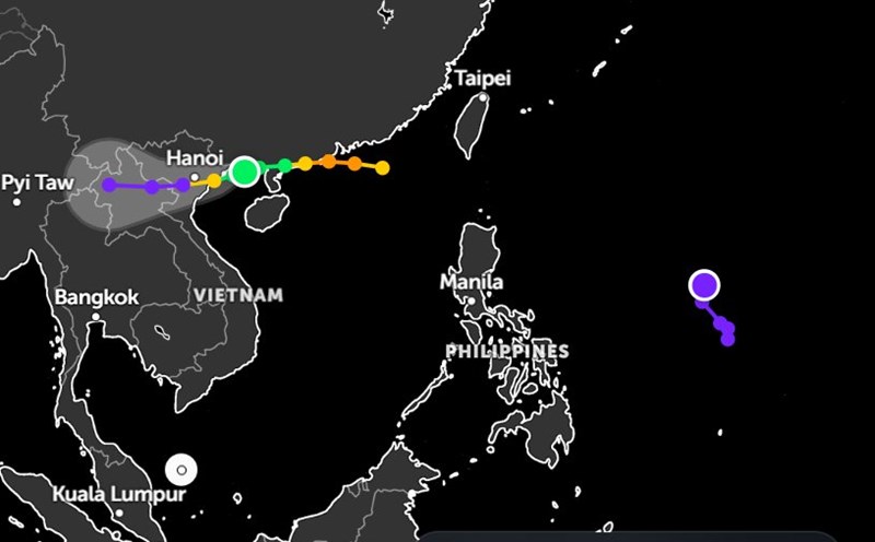
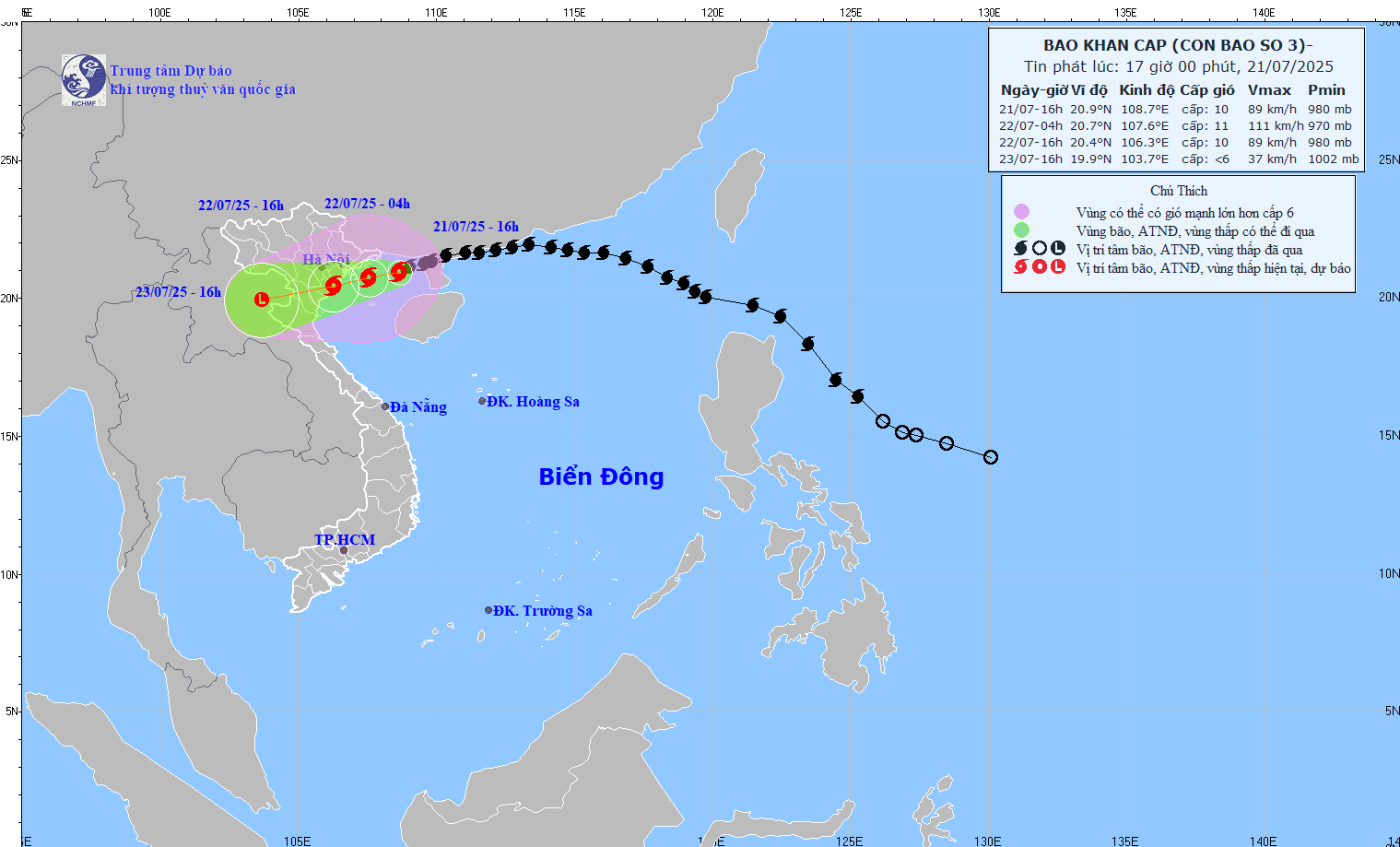
According to emergency storm news from the National Center for Hydro-Meteorological Forecasting, at 4:00 p.m. on July 21, the center of storm No. 3 Wipha was at about 20.9°N; 108.7°E, 100km from Quang Ninh, 220km from Hai Phong, 240km from Hung Yen, 270km from Ninh Binh.
The strongest wind is level 9-10 (75-102km/h), gusting to level 12. The storm is moving in a West-Southwest direction at a speed of about 15km/h.
It is forecasted that by 4:00 a.m. on July 22, storm No. 3 in the North of the Gulf of Tonkin (20.7°N; 107.6°E), strong at level 10-11, gusting to level 14, is likely to strengthen.
The storm forecast bulletin of the Joint Typhoon Warning Center (JTWC) recorded that Typhoon Wipha is about 320km east of Hanoi and moving west-southwest at a speed of about 13km/h.
Currently, the largest wave height generated by the storm is up to 4.9 meters.
When entering the very warm waters of the Gulf of Tonkin, the storm is likely to strengthen slightly, reaching winds of about 95-100km/h in the next 12 hours.
The JTWC forecasts that the storm's winds may be about 10-20km/h higher than average models, due to small scale but favorable environmental conditions in the northern Gulf of Tonkin.
The storm is forecast to make landfall in the next 12 to 24 hours and continue to weaken as it moves further inland.
The storm is likely to completely dissipate within 2 days. Current forecast models from international meteorological agencies show a high level of consensus on the storm's path, with an error of about 74km at the time of landfall.
All models predict that storm No. 3 Wipha will sweep through the eastern or southeastern areas of Hanoi, the areas bordering Hung Yen and Ninh Binh provinces.
The storm will then continue moving west.
From the evening of July 21, Hanoi weather began to experience localized thunderstorms due to the approach of the tropical depression, with rainfall gradually increasing at night and early morning.
Hanoi weather forecast from Weather Channel, continuous rain from the night of July 21 to the morning of July 22, rainfall ranging from about 1-3 mm per hour, sometimes reaching 4 mm/h and scattered thunderstorms from about 10am to 6pm on July 22.
In the next 3 days (22-24.7.), Hanoi will continue to experience prolonged rain and heavy thunderstorms, with total daily rainfall reaching 50-125mm/day, even in areas strongly affected that can exceed 200mm/day.
From the evening of July 21 to July 23, the Northeast region, the Northern Delta, Thanh Hoa and Nghe An will have heavy to very heavy rain and thunderstorms. Total rainfall is generally 200-350mm, in some places over 600mm.
Other areas of the North and Ha Tinh will have moderate rain, heavy rain, locally very heavy rain. The common rainfall was 100-200mm, in some places over 300mm.
Warning of the possibility of heavy rain with a high intensity of over 150mm within 3 hours, risk of flooding, flash floods and landslides in mountainous areas.
In addition, on the night of July 21 and July 22, the area from Quang Tri to Da Nang, the Central and Southern highlands will have scattered showers and thunderstorms. Localized heavy rain with common rainfall of 10-30mm, some places over 70mm, concentrated in the afternoon and evening.
During thunderstorms, tornadoes, lightning, hail and strong gusts of wind may occur. People and tourists need to closely monitor weather developments and limit travel during heavy rains, especially in areas at risk of deep flooding, landslides or rising rivers and streams.
People and tourists need to be on guard against tornadoes, lightning and be vigilant against flooding.
Thunderstorms accompanied by strong winds can cause trees to fall, landslides or rising water in riverside areas. Tourists should not gather, camp or travel through these areas during storms.
In case of changes in activities in tourist areas and destinations, accommodation facilities will be an important source of information to support tourists to adjust their plans or ensure safety.