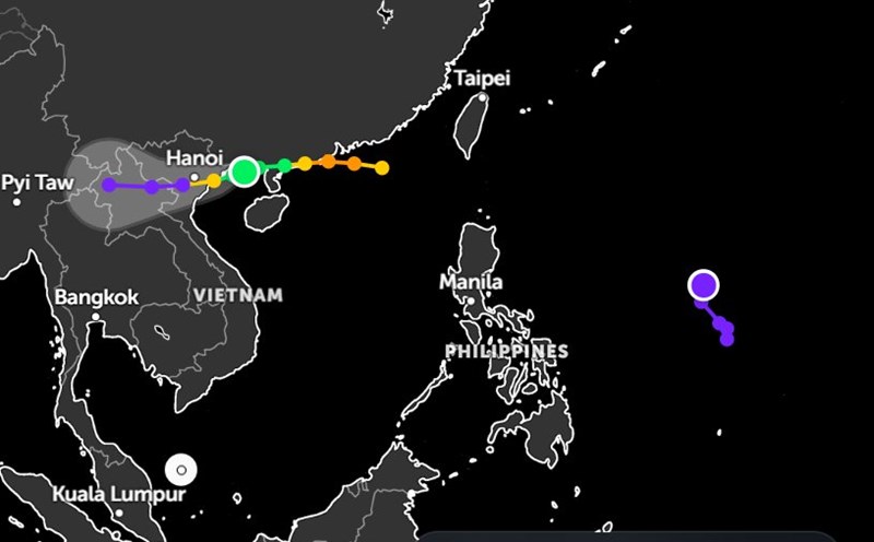
According to the latest storm news from the National Center for Hydro-Meteorological Forecasting, at 4:00 p.m. on July 21, the center of the storm was at about 20.9°N; 108.7°E.
Storm No. 3 Wipha is 100km from Quang Ninh, 220km from Hai Phong, 240km from Hung Yen, 270km from Ninh Binh.
The strongest wind is level 9-10 (75-102km/h), gusting to level 12. The storm is moving in a West-Southwest direction at a speed of about 15km/h.
It is forecasted that by 4:00 a.m. on July 22, the storm in the North of the Gulf of Tonkin (20.7°N; 107.6°E), strong at level 10-11, gusting to level 14, is likely to strengthen.
By 4:00 p.m. on July 22, storm No. 3 Wipha is forecast to be on the mainland in the coastal area from Hai Phong to Thanh Hoa (20.4°N; 106.3°E), strong at level 9-10, gusting to level 13.
From the night of July 21, in the coastal areas of the provinces from Quang Ninh to Nghe An, the wind will gradually increase to level 7-9. The area near the storm's eye may reach level 10-11, gusting to level 14.
In areas deep inland such as Hai Phong, Hung Yen, Bac Ninh, Hanoi, Ninh Binh and Thanh Hoa, the common wind is level 6, gusting to level 7-8. With strong winds of level 10-11, there is a high risk of falling trees, breaking electric poles and blocking people's roofs.

From the evening of July 21 to July 23, the Northeastern provinces, the Northern Delta, Thanh Hoa and Nghe An will have heavy to very heavy rain, with total rainfall generally 200-350mm, some places exceeding 600mm.
Other areas in the North and Ha Tinh will have moderate rain, heavy rain, some places will have very heavy rain with total rainfall of 100-200mm, some places will have over 300mm.
In addition, on the night of July 21 and July 22, the area from Quang Tri to Da Nang, the Central and Southern Plateau will have scattered showers and thunderstorms, locally heavy rain (10-30mm), some places over 70mm (concentrated in the afternoon and evening).
In the northwest of the East Sea, strong winds of level 7-8, gusting to level 10. Waves are 3.0-5.0m high, rough seas.
Warning of the risk of high-intensity heavy rain, exceeding 150mm within 3 hours. The situation of heavy rain can cause flash floods, landslides in mountainous areas and flooding in low-lying areas in the midlands and plains.
In the northern Gulf of Tonkin (including the areas of Bach Long Vi, Co To, Van Don, Cat Hai, Hon Dau), strong winds of level 6-7, then increase to level 8-9.
The area near the storm center has winds of level 10-11, gusting to level 14. The common high waves are 2.0-4.0m, with the area near the center of the storm being 4.0-4.0m high. The sea is rough.
In the southern Gulf of Tonkin (Hon Ngu area), strong winds of level 6-7. The area near the storm center will reach level 8-9, gusting to level 11. Waves are 2.0-4.0m high, the sea is very rough.
The storm's water level in the coastal area from Hung Yen to Quang Ninh ranges from 0.5-1.0m.
Risk of flooding in coastal areas and river mouths on the afternoon of July 22.
Weather forecast for tonight, July 21, and tomorrow, July 22:
Hanoi Lowest temperature: 23-25 degrees Celsius Highest temperature: 27-29 degrees Celsius Cloudy, heavy to very heavy rain.
The wind will gradually increase to level 3-4, from tomorrow it will increase to level 5-6, gusting to level 7-8.
Northwest Lowest temperature: 23-26 degrees Celsius, some places below 22 degrees Celsius Highest temperature: 27-30 degrees Celsius, some places above 30 degrees Celsius Cloudy, moderate rain, heavy rain and thunderstorms, locally very heavy rain.
West to northwest wind level 2-3.During thunderstorms, there is a possibility of tornadoes, lightning and strong gusts of wind.
Northeast Lowest temperature: 23-26 degrees Celsius, some places below 22 degrees Celsius Highest temperature: 27-30 degrees Celsius, some mountainous areas above 30 degrees Celsius Cloudy, moderate rain, heavy rain.
In particular, the Northeast and the plains will have heavy to very heavy rain.Hai Phong, Hung Yen, Ninh Binh have strong winds of level 6, gusting to level 7-8.
In particular, coastal areas from Quang Ninh to Ninh Binh will have winds gradually increasing to level 7-9, near the storm center level 10-11, gusting to level 14. Other places will have winds gradually increasing to level 3-4.
From Thanh Hoa to Hue Lowest temperature: 24-27 degrees Celsius Highest temperature: 27-30 degrees Celsius, some places in the south are above 31 degrees Celsius Cloudy.
The north has moderate rain, heavy rain and thunderstorms, while Thanh Hoa - Nghe An has heavy to very heavy rain.The south has scattered showers and thunderstorms.
The coastal area of Thanh Hoa - Nghe An has winds gradually increasing to level 7-9, near the storm center level 10-11, gusting to level 14. The deep inland area of Thanh Hoa has strong winds of level 6, gusting to level 7-8.
Other places have southwest winds at level 3-4. During thunderstorms, there is a possibility of tornadoes, lightning and strong gusts of wind.
South Central Coast Lowest temperature: 26-29 degrees Celsius Highest temperature: 31-34 degrees Celsius Cloudy, with showers and thunderstorms in some places.
Southwest wind level 3-4.During thunderstorms, there is a possibility of tornadoes, lightning, hail and strong gusts of wind.
Central Highlands Lowest temperature: 20-23 degrees Celsius Highest temperature: 25-28 degrees Celsius, some places above 28 degrees Celsius Cloudy, scattered showers and thunderstorms.
In the afternoon and evening, there will be scattered showers and thunderstorms, with some places having heavy rain.Southwest wind level 3-4.During thunderstorms, there is a possibility of tornadoes, lightning and strong gusts of wind.
Southern region Lowest temperature: 23-26 degrees Celsius Highest temperature: 30-33 degrees Celsius, some places above 33 degrees Celsius Cloudy, scattered showers and thunderstorms.
In the afternoon and evening, there will be scattered showers and thunderstorms, with some places having heavy rain.Southwest wind level 3.During thunderstorms, there is a possibility of tornadoes, lightning and strong gusts of wind.
Ho Chi Minh City Lowest temperature: 23-26 degrees Celsius Highest temperature: 31-33 degrees Celsius Cloudy, with showers and thunderstorms in some places.In the afternoon and evening, there will be scattered showers and thunderstorms, with some places having heavy rain.
Southwest wind level 3.During thunderstorms, there is a possibility of tornadoes, lightning and strong gusts of wind.