Potential super typhoon revealed, forecast to enter the East Sea after storm No. 13 Kalmaegi

Ninh Phương |

The newly formed tropical depression is forecast to develop into a super typhoon, following storm No. 13 Kalmaegi into the East Sea.

According to the latest storm forecast from the Philippine Atmospheric and Geophysical Agency (PAGASA), a new tropical depression is forming in the Pacific Ocean and is likely to strengthen into a super typhoon when it enters the Philippine Area (PAR) this weekend.

The tropical depression is moving right after storm Kalmaegi, which caused great damage in the Central and Southern Philippines.

According to PAGASA, the tropical depression currently has sustained winds of 55 km/h, gusts of 70 km/h and is expected to enter PAR on Friday night, November 7 or Saturday morning, November 8.

The tropical depression is located about 1,985km northeast of Mindanao, moving west at a speed of about 20km/h, then turning west-northwest as it approaches PAR.

PAGASA forecasts that the tropical depression will continuously strengthen over the sea and may reach typhoon level on November 6 before reaching super typhoon strength over the weekend.

When it enters the Philippines, the storm will be named Uwan.

The meteorological agency also warned of the possibility of Typhoon Uwan making landfall in the Philippines, but the specific location and time are still uncertain as there are more than 5 days away.

Du bao duong di va vung chiu anh huong cua ap thap nhiet doi co kha nang dat cap sieu bao, vao Bien Dong ngay sau bao so 13 Kalmaegi. Anh: JMA
The forecast track and area affected by the tropical depression is likely to reach super typhoon level, entering the East Sea right after storm No. 13 Kalmaegi. Photo: JMA

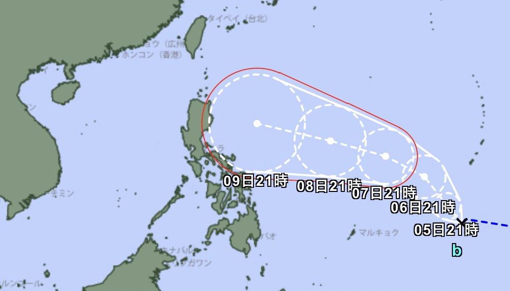
The new tropical depression has not yet directly affected the weather on the Philippine mainland, but from Saturday, November 8, the sea in the North and East of the Philippines will start to rise with strong waves and bad weather.

Meanwhile, Typhoon No. 13 Kalmaegi with winds of 140 km/h left behind heavy damage when it made landfall in the Philippines near midnight on Monday, November 3.

Recommendations for tourists during the active period of storm No. 13 Kalmaegi

Follow national forecasts closely, especially if you plan to fly over Manila, Philippines or connect to the Philippines.

Limit booking tours close to the date, as the sea weather can deteriorate rapidly due to the wide influence of storm No. 13 Kalmaegi.

Check flight schedules because there is a possibility of flight delays - changes, especially at airports in Central Vietnam such as Da Nang, Chu Lai, Quy Nhon, Pleiku, Buon Ma Thuot.

Ninh Phương
TIN LIÊN QUAN

Storm No. 13 Kalmaegi gusts to level 17, Central region is about to have more than 600mm of rain

|

Storm No. 13 Kalmaegi is forecast to be active in the East Sea, and will make landfall in Vietnam around the morning of November 7.

Forecast of the first areas affected by storm No. 13 Kalmaegi

|

Weather forecast for the morning of November 5, storm No. 13 Kalmaegi has officially made landfall in the East Sea, starting to affect some coastal and inland areas of Vietnam.

Storm No. 13 Kalmaegi begins to bring heavy rain to the mainland in the next 24 hours

|

Storm No. 13 Kalmaegi is moving very quickly in the East Sea, the storm is forecast to make landfall in Vietnam within the next 48 hours.

Forecast of the provinces and cities with the heaviest rain when storm No. 13 Kalmaegi makes landfall

|

The influence of storm No. 13 Kalmaegi is very large, causing heavy rain, thunderstorms, tornadoes and strong gusts of wind both before and during the storm making landfall in Vietnam.

Weather forecast for today, November 5: Storm No. 13 Kalmaegi officially enters the East Sea

|

Weather forecast for today, November 5, storm No. 13 Kalmaegi officially entered the East Sea, causing severe thunderstorms at sea.

Tropical depression strengthens into a storm immediately after storm No. 13 Kalmaegi

|

A tropical depression is forecast to strengthen into a storm near the East Sea right after storm No. 13 Kalmaegi.

Storm No. 13 Kalmaegi gusts to level 17, Central region is about to have more than 600mm of rain

Chí Long |

Storm No. 13 Kalmaegi is forecast to be active in the East Sea, and will make landfall in Vietnam around the morning of November 7.

Forecast of the first areas affected by storm No. 13 Kalmaegi

Chí Long |

Weather forecast for the morning of November 5, storm No. 13 Kalmaegi has officially made landfall in the East Sea, starting to affect some coastal and inland areas of Vietnam.

Storm No. 13 Kalmaegi begins to bring heavy rain to the mainland in the next 24 hours

Ninh Phương |

Storm No. 13 Kalmaegi is moving very quickly in the East Sea, the storm is forecast to make landfall in Vietnam within the next 48 hours.

Forecast of the provinces and cities with the heaviest rain when storm No. 13 Kalmaegi makes landfall

Ninh Phương |

The influence of storm No. 13 Kalmaegi is very large, causing heavy rain, thunderstorms, tornadoes and strong gusts of wind both before and during the storm making landfall in Vietnam.

Weather forecast for today, November 5: Storm No. 13 Kalmaegi officially enters the East Sea

Chí Long |

Weather forecast for today, November 5, storm No. 13 Kalmaegi officially entered the East Sea, causing severe thunderstorms at sea.

Tropical depression strengthens into a storm immediately after storm No. 13 Kalmaegi

Chí Long |

A tropical depression is forecast to strengthen into a storm near the East Sea right after storm No. 13 Kalmaegi.