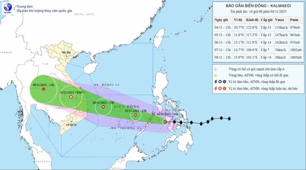
According to the new storm news of the National Center for Hydro-Meteorological Forecasting, today, November 5, storm No. 13 Kalmaegi officially entered the East Sea.
On the evening of November 5, the center of the storm was at about 12.3 degrees North latitude - 116.0 degrees East longitude, about 220 km northeast of Song Tu Tay Island. The storm is moving west-northwest at a speed of 20-25km/h and is likely to strengthen.
The strongest wind near the storm center is level 13-14, gusting to level 17. Natural disaster risk level: level 4 for the Central East Sea area (including the sea area north of Truong Sa special zone).
Due to the influence of the storm, the Central East Sea area (including the sea area north of Truong Sa special zone) will gradually increase to level 7-8, then increase to level 9-11; the area near the storm's eye will be strong at level 12-14, gusting to level 17, waves 5.0-4.0m high, the area near the storm's eye will be 8.0-10.0m high; the sea will be very rough.
From early morning on November 6, the sea area from Da Nang City to Khanh Hoa (including Ly Son special zone) will have winds gradually increasing to level 6-7, then increasing to level 8-11, the area near the storm's eye will have strong winds of level 12-14, gusting to level 17. Coastal areas from Hue City to Dak Lak have waves 4.0-6.0m high, near the storm's eye 6.0 8.0m high; rough seas.
From the evening of November 6, on the mainland along the coast from South Quang Tri to Da Nang, the East of Quang Ngai and Dak Lak provinces, the wind will gradually increase to level 6-7, then increase to level 8-9, the area near the storm's eye will have strong winds of level 10-12 (focusing on the East of Quang Ngai - Dak Lak provinces), gusting to level 14-15. In the West of Quang Ngai and Gia Lai provinces, the wind gradually increased to level 6-7, near the storm's eye, it passed strongly at level 8, gusting to level 10.
People and tourists planning to visit these coastal areas should pay attention to weather forecasts. Follow local instructions to avoid dangerous storms and big waves.
Weather forecast for today, November 5th nationwide:
City. Hanoi
Lowest temperature: 17-19 degrees Celsius.
Highest temperature: 23-25 degrees Celsius.
Cloudy, no rain, sunny in the afternoon.Light wind.Cold at night and morning.
Northwest
Lowest temperature: 17-20 degrees Celsius, some places below 16 degrees Celsius.
Highest temperature: 23-26 degrees Celsius.
Cloudy, some rain, sunny in the afternoon.Light wind.Cold at night and morning.
Northeast
Lowest temperature: 16-19 degrees Celsius, mountainous areas below 15 degrees Celsius.
Highest temperature: 22-25 degrees Celsius.
Cloudy, some rain, sunny in the afternoon.Light wind.Cold at night and morning.
Thanh Hoa to Hue
Lowest temperature: 19-22 degrees Celsius.
Highest temperature: North 22-24 degrees Celsius, South 25-28 degrees Celsius.
Cloudy, scattered showers and thunderstorms, locally heavy rain.North to northwest wind level 2-3.Cold at night and morning.
South Central Coast
Lowest temperature: 23-26 degrees Celsius.
Highest temperature: 30-33 degrees Celsius.
The North is cloudy, with scattered showers and thunderstorms, locally heavy rain; the South is cloudy, with scattered showers and thunderstorms in some places, in the afternoon and evening there are scattered showers and thunderstorms, locally heavy rain in some places.North to northeast wind level 2-3.During thunderstorms, there is a possibility of tornadoes, lightning and strong gusts of wind.
Central Highlands
Lowest temperature: 20-23 degrees Celsius.
Highest temperature: 28-31 degrees Celsius.
Cloudy, scattered showers and thunderstorms in some places; in the afternoon and evening, there will be scattered showers and thunderstorms, locally heavy rain in some places.Light wind.During thunderstorms, there is a possibility of tornadoes, lightning, hail and strong gusts of wind.
Southern region
Lowest temperature: 23-26 degrees Celsius.
Highest temperature: 30-33 degrees Celsius.
Cloudy, scattered showers and thunderstorms in some places; in the afternoon and evening, there will be scattered showers and thunderstorms, locally heavy rain in some places.Light wind.During thunderstorms, there is a possibility of tornadoes, lightning, hail and strong gusts of wind.
Ho Chi Minh City
Lowest temperature: 24-26 degrees Celsius.
Highest temperature: 31-33 degrees Celsius.
Cloudy, scattered showers and thunderstorms in some places; in the afternoon and evening, there will be scattered showers and thunderstorms, locally heavy rain in some places.Light wind.During thunderstorms, there is a possibility of tornadoes, lightning, hail and strong gusts of wind.


