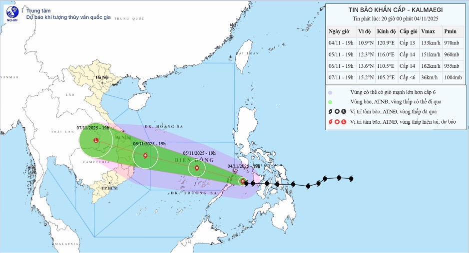
According to the latest storm news from the National Center for Hydro-Meteorological Forecasting, on November 5, storm No. 13 Kalmaegi officially entered the East Sea.
The storm maintains a speed of about 20-25km/h, heading towards the Central region.
Storm No. 13 Kalmaegi reached the intensity of level 13-14, gusting to level 17 - super typhoon level. The storm is forecast to strengthen as it moves over the East Sea, before making landfall in Vietnam from around the morning of November 7.
From November 6-7, the area from Da Nang City to Dak Lak will have very heavy rain with common rainfall of 200-400mm/ods, locally over 600mm/ods.
The area from South Quang Tri to Hue City, Khanh Hoa and Lam Dong will have heavy rain with common rainfall of 150-300mm/ods, locally very heavy rain over 450mm/ods. The rain will gradually decrease from November 8.
From November 7-8, the North of Quang Tri to Thanh Hoa will have moderate rain, heavy rain with common rainfall of 50-150mm/ods, locally very heavy rain over 200mm/ods.
Due to the influence of a wide storm circulation, it is necessary to be on guard against the risk of thunderstorms, tornadoes and strong gusts of wind both before and during the landfall of storm No. 13 Kalmaegi.
From early morning on November 6, the sea area from Da Nang City to Khanh Hoa (including Ly Son special area) will gradually increase to level 6-7, then increase to level 8-11, the area near the storm's eye will be strong at level 12-14, gusting to level 17; coastal areas from Hue City to Dak Lak will have waves 4.0-6.0m high, the area near the storm's eye will be 6.0 8.0 8.0m high; the sea will be very rough.
From the evening of November 6, coastal areas from Hue City to Dak Lak should be on guard against rising sea levels accompanied by large waves causing flooding in low-lying areas, waves of dike overflow, coastal roads, and coastal erosion, slowing flood drainage in the area.
On the mainland along the coast from South Quang Tri to Da Nang, the East of Quang Ngai and Dak Lak provinces, the wind will gradually increase to level 6-7, then increase to level 8-9, the area near the storm's eye will be strong at level 10-12 (focusing on the East of Quang Ngai - Dak Lak provinces), gusting to level 14-15.
From the evening and night of November 6, the wind in the West of Quang Ngai and Gia Lai provinces will gradually increase to level 6-7, near the storm's eye, level 8, gusting to level 10.
People and tourists should regularly update official meteorological bulletins, especially if they plan to travel to the Central region or go to sea in the coming days.
If you are planning to visit coastal areas of Vietnam such as Da Nang, Hue, Quy Nhon, Nha Trang or Phu Quoc, you should avoid booking an island tour close to the storm's land (cano, coral diving...).
If the sea is rough due to remote influence, some localities may temporarily stop ships going to the island such as Ly Son, Cu Lao Cham, Con Dao, Phu Quy...


