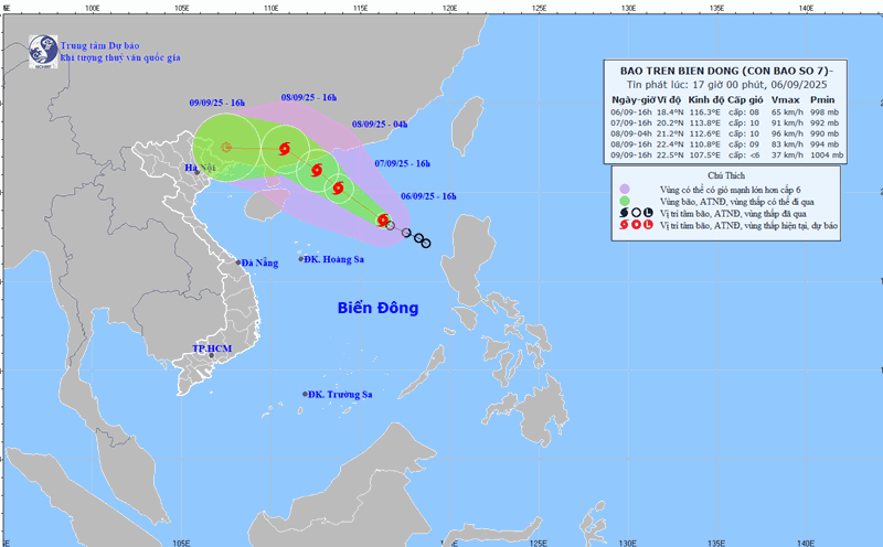
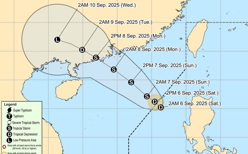
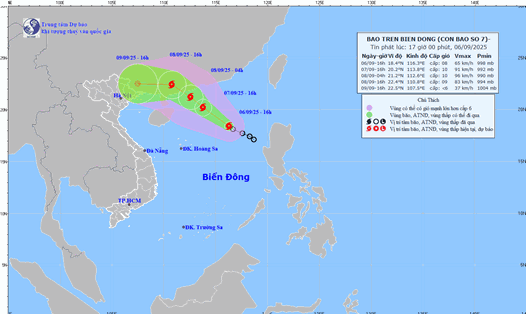
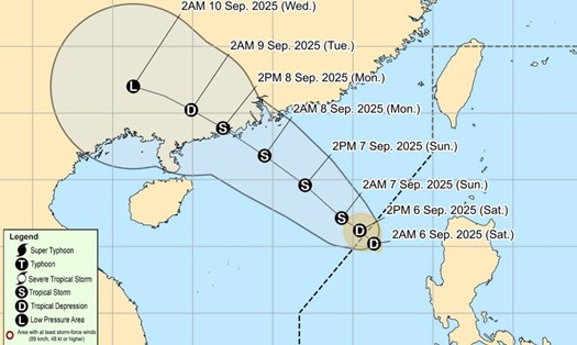
According to the latest storm news from the National Center for Hydro-Meteorological Forecasting, the tropical depression in the northeastern sea of the East Sea has officially strengthened into storm No. 7 (Tapah).
Updated location of storm No. 7 Tapah
At 7:00 p.m., the center of storm No. 7 Tapah was at about 18.3°N - 115.8°E, in the northeastern sea of the East Sea.
The strongest wind near the storm center is level 8 (62-74 km/h), gusting to level 10. The storm is moving northwest at a speed of 10-15 km/h.
Forecast of the development of Typhoon No. 7 Tapah, at 7:00 p.m. on September 7, the storm was located at about 20.5°N - 113.5°E, about 220 km south-southeast of Hong Kong (China).
The storm intensity reached level 10, gusting to level 12. Natural disaster risk level: level 3 for the northern sea area of the East Sea.
As of 7:00 p.m. on September 8, the storm was at about 22.4°N - 110.5°E, on the mainland of Guangdong province (China).
The storm intensity is still level 8-9, gusting to level 11. Natural disaster risk level: level 3 for the northwestern sea area of the East Sea. At 07:00 on September 9, the storm was located at about 22.7°N - 108.1°E, in the mainland of Guangxi province (China).
The storm intensity will weaken below level 6, decrease to a tropical depression and then continue to weaken into a low pressure area.
Forecast of the impact of storm No. 7 Tapah
At sea, the northeastern sea of the East Sea will have strong winds of level 7-8, near the storm center will have strong winds of level 9-10, gusting to level 13. Waves are 3.0-5.0 m high, very rough seas.
Ship operating in the dangerous area are likely to be affected by thunderstorms, whirlwinds, strong winds and large waves.
Recommendation
Tourists planning to travel by sea or participate in sea activities in the coming days should closely monitor the storm forecast bulletin.
Limit travel through the northeastern and northwestern seas of the East Sea due to strong winds, big waves and very rough seas.
Travel to Hong Kong, Guangdong and Guangxi (China) from September 7 to 9 may be affected by heavy rain, strong winds and disrupted traffic.
Consider adjusting your schedule, following the instructions of the authorities and always ensuring safety when traveling.
Weather forecast for the regions from the night of September 6 to September 8, the North and the area from Thanh Hoa to Ha Tinh, showers and thunderstorms in the evening and at night, sunny during the day, hot in some places.
In the area from Da Nang city to Lam Dong and the South, on the night of September 6 and 7, there will be rain, moderate rain and thunderstorms, locally heavy rain to very heavy rain; on the night of September 7 and 8, there will be scattered showers and thunderstorms in the afternoon and evening, locally heavy rain.
Other areas will have scattered showers and thunderstorms, with scattered showers and thunderstorms in the late afternoon and evening. During thunderstorms, there is a possibility of tornadoes, lightning, hail and strong gusts of wind.