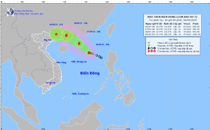
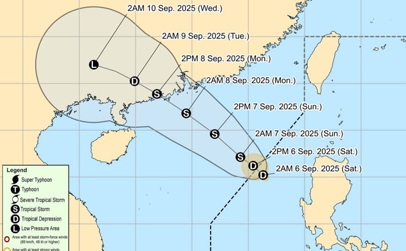
According to the latest storm news from the National Center for Hydro-Meteorological Forecasting, this afternoon, September 6, the tropical depression in the northeastern sea of the East Sea has strengthened into a storm, storm No. 7.
At 4:00 p.m., the center of the storm was at about 18.4°N - 116.3°E, in the northeastern sea of the East Sea.
The strongest wind is level 8 (62074 km/h), gusting to level 10. Moving northwest, speed 15 km/h.
By 4:00 p.m. on September 7, the storm moved northwest at a speed of 10-15 km/h, continuing to strengthen.
Location at 20.2°N - 113.8°E, about 420 km northeast of the Hoang Sa archipelago.
Strong wind level 9-10, gust level 12. Dangerous area: latitude 17.0-22.0°N; longitude 112.0-117.5°E. Natural disaster risk level: level 3, the northern sea area of the East Sea.
At 4:00 a.m. on September 8, the storm continued to move northwest at a speed of 10-15 km/h and strengthened. Location at 21.2°N - 112.6°E, about 110 km south-southeast of Hong Kong (China).
Strong wind level 10, gust level 13. Dangerous area: north of latitude 18.0°N; longitude 110.0-116.5°E. Natural disaster risk level: level 3, the northwest sea area of the East Sea.
By 4:00 p.m. on September 9, the storm moved mainly westward, at a speed of about 15 km/h, weakening into a tropical depression, then a low pressure area. Location is at 22.5°N - 107.5°E, in the mainland of Guangxi province (China). Intensity below level 6.
At sea: The northeastern sea area of the East Sea has strong winds of level 6-7, then increasing to level 7-8; the area near the storm's eye has strong winds of level 9-10, gusting to level 13. Waves are 3.0-5.0 m high, the sea is very rough.
People and tourists should note that boats operating in dangerous areas are likely to be affected by thunderstorms, whirlwinds, strong winds and large waves.

Weather forecast for tonight, September 6 and tomorrow, September 7:
Hanoi Lowest temperature: 26-28 degrees Celsius Highest temperature: 33-35 degrees Celsius, some places above 35 degrees Celsius Cloudy, no rain at night, hot during the day.
Light wind.
Northwest Lowest temperature: 23-26 degrees Celsius, some places below 22 degrees Celsius Highest temperature: 32-35 degrees Celsius, some places above 35 degrees Celsius Cloudy, showers and thunderstorms in the evening and at night; sunny during the day, some places are hot.
Light wind.
Northeast Lowest temperature: 25-28 degrees Celsius, mountainous areas below 23 degrees Celsius Highest temperature: 32-35 degrees Celsius, some places above 35 degrees Celsius Cloudy, showers and thunderstorms in the evening and at night; sunny during the day, some places are hot.
Light wind.
Thanh Hoa to Hue Lowest temperature: 25-28 degrees Celsius Highest temperature: 31-34 degrees Celsius Cloudy, showers and thunderstorms in the evening and at night; sunny day, hot sun in some places, scattered showers and thunderstorms in the South in the late afternoon and evening.
Light wind.During thunderstorms, there is a possibility of tornadoes, lightning and strong gusts of wind.
South Central Coast Lowest temperature: 23-26 degrees Celsius Highest temperature: 30-33 degrees Celsius, some places above 33 degrees Celsius Cloudy, rain, moderate rain and thunderstorms, locally heavy to very heavy rain.
Light wind in the North, southwest wind level 2-3.During thunderstorms, there is a possibility of tornadoes, lightning and strong gusts of wind.
Central Highlands Lowest temperature: 20-23 degrees Celsius Highest temperature: 24-28 degrees Celsius, some places above 28 degrees Celsius Cloudy, rain, moderate rain and thunderstorms, locally heavy to very heavy rain.
Southwest wind level 2-3.During thunderstorms, there is a possibility of tornadoes, lightning and strong gusts of wind.
Southern region Lowest temperature: 24-27 degrees Celsius Highest temperature: 30-33 degrees Celsius Cloudy, rain, moderate rain and thunderstorms, locally heavy to very heavy rain.
Southwest wind level 2-3.During thunderstorms, there is a possibility of tornadoes, lightning and strong gusts of wind.
Ho Chi Minh City Lowest temperature: 25-27 degrees Celsius Highest temperature: 29-31 degrees Celsius Cloudy, rain, moderate rain and thunderstorms, locally heavy to very heavy rain.Southwest wind level 2-3.
During thunderstorms, there is a possibility of tornadoes, lightning and strong gusts of wind.