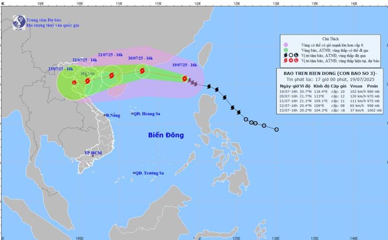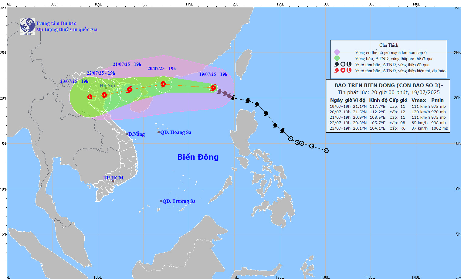
According to the latest storm news from the National Center for Hydro-Meteorological Forecasting, on the evening of July 19, the center of storm No. 3 Wipha was at about 21.1 degrees North latitude; 117.7 degrees East longitude, in the northeastern sea area of the North East Sea.
The strongest wind near the storm center is level 10-11 (89-117km/h), gusting to level 14; moving in the West Northwest direction at a speed of about 20-25km/h.
It is forecasted that at 7:00 p.m. on July 20, storm No. 3 Wipha will move in the West Northwest direction, then turn to the West at a speed of 20-25km/h and is likely to continue to strengthen. At this time, the center of the storm is at about 21.5 degrees North latitude - 112.2 degrees East longitude, in the northwest sea of the North East Sea, about 220km east of the Lusian Peninsula (China).
The strongest wind near the storm center is level 11-12, gusting to level 15. Dangerous sea areas with strong winds of level 6 or higher are located between latitudes 19.0 to 23.0 degrees North latitude and longitude 110.5 to 120.0 degrees East longitude.
Natural disaster risk level: level 3, applied to the northern sea area of the North East Sea.
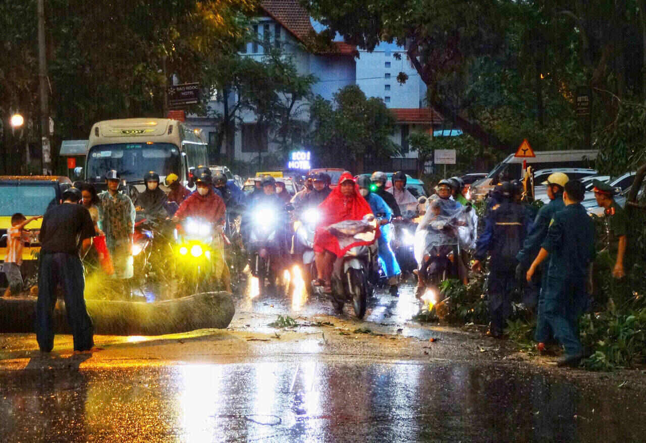
On the evening and night of July 19, the North and the area from Thanh Hoa to Quang Tri will have showers and scattered thunderstorms, locally heavy rain with common rainfall of 20-40mm, some places over 80mm.
People and tourists need to be on guard against the risk of flash floods and landslides in some areas such as Muong La, Chieng Hoa, Moc Chau, Van Ho, Xim Vang, Xuan Nha, Yen Chau, Yen Son... in Son La and areas such as Ba Thuoc, Muong Lat, Phu Xuan, Pu Luong... in Thanh Hoa.
The Central and Southern highlands will continue to have scattered showers and thunderstorms, locally heavy rain of 10-20mm, some places over 40mm.
From the afternoon of July 21 to July 23, the North and North Central regions are likely to experience a widespread heavy rain, with common rainfall of 100-200mm, some places over 300mm.
In the Northeast, the Northern Delta, Thanh Hoa and Nghe An, there will be heavy to very heavy rain of 200-350mm, locally over 600mm.
The area from Quang Tri to Da Nang, the East of the provinces from Quang Ngai to Dak Lak and Khanh Hoa will have scattered showers and thunderstorms; on July 20, there will be hot weather, some places will be very hot.

Other areas will have scattered showers and thunderstorms; the Central and Southern Plateau will have scattered showers and thunderstorms in the afternoon and evening, with some places having heavy rain.
Tourists should proactively monitor weather forecasts, bring umbrellas or raincoats when traveling, and limit outdoor areas during heavy rain and thunderstorms.
For a safe and complete experience, visitors can choose indoor attractions, especially cultural and artistic exhibitions.
Weather forecast for tonight, July 19, and tomorrow, July 20:
Hanoi City Lowest temperature: 26-28 degrees Celsius Highest temperature: 34-36 degrees Celsius Cloudy, showers and thunderstorms in the evening and at night, locally heavy rain; hot sunny day.
Light wind.During thunderstorms, there is a possibility of tornadoes, lightning, hail and strong gusts of wind.
Northwest Lowest temperature: 23-26 degrees Celsius, some places below 23 degrees Celsius Highest temperature: 30-33 degrees Celsius; Lao Cai, Yen Bai and the western area of Phu Tho 33-36 degrees Celsius Cloudy, scattered showers and thunderstorms in the evening and at night, locally heavy rain; sunny day, especially Lao Cai, Yen Bai and the western area of Phu Tho have hot weather.
Light wind.During thunderstorms, there is a possibility of tornadoes, lightning, hail and strong gusts of wind.
Northeast Lowest temperature: 25-28 degrees Celsius Highest temperature: 33-36 degrees Celsius Cloudy, scattered showers and thunderstorms in the evening and at night, locally heavy rain; hot sunny day.
Light wind.During thunderstorms, there is a possibility of tornadoes, lightning, hail and strong gusts of wind.
Thanh Hoa to Hue Lowest temperature: 26-29 degrees Celsius Highest temperature: 34-37 degrees Celsius, some places above 37 degrees Celsius Cloudy, showers and thunderstorms in the evening and at night, scattered showers and thunderstorms in the North, locally heavy rain; hot sunny day, some places are very hot.
West to southwest wind level 2-3.During thunderstorms, there is a possibility of tornadoes, lightning, hail and strong gusts of wind.
South Central Coast Lowest temperature: 26-29 degrees Celsius Highest temperature: 34-37 degrees Celsius Cloudy, showers and thunderstorms in the evening and at night; sunny during the day, some places are hot; the North is hot.
Southwest wind level 2-3.During thunderstorms, there is a possibility of tornadoes, lightning, hail and strong gusts of wind.
Central Highlands Lowest temperature: 20-23 degrees Celsius Highest temperature: 26-29 degrees Celsius, some places above 29 degrees Celsius Cloudy, scattered showers and thunderstorms in some places, scattered showers and thunderstorms in the afternoon and evening, locally heavy rain in some places.
Southwest wind level 2-3.During thunderstorms, there is a possibility of tornadoes, lightning and strong gusts of wind.
Southern region Lowest temperature: 24-27 degrees Celsius Highest temperature: 29-32 degrees Celsius, some places above 32 degrees Celsius Cloudy, scattered showers and thunderstorms in some places, scattered showers and thunderstorms in the afternoon and evening, locally heavy rain in some places.
Southwest wind level 2-3.During thunderstorms, there is a possibility of tornadoes, lightning and strong gusts of wind.
Ho Chi Minh City Lowest temperature: 25-27 degrees Celsius Highest temperature: 30-32 degrees Celsius Cloudy, scattered showers and thunderstorms in some places, in the afternoon and evening there are scattered showers and thunderstorms, locally heavy rain in some places.Southwest wind level 2-3.
During thunderstorms, there is a possibility of tornadoes, lightning and strong gusts of wind.