According to the latest typhoon information from the Joint Typhoon Warning Center (JTWC), super typhoon Fung-wong - also known as typhoon Uwan according to the Philippines - is located about 415 km east of Manila and moving rapidly in the West Northwest direction.
The new storm forecast from the Philippine Meteorological Agency (PAGASA) shows that the super typhoon currently has the strongest winds near the center at about 185 km/h, gusting to 230 km/h. The strong wind radius extends up to 800 km, with strong winds threatening human life and possibly destroying many structures.
Super typhoon Fung-wong is moving at a speed of about 30 km/h.
Waves near the center of the storm are up to 14 m high, posing a serious danger to ships and offshore activities.
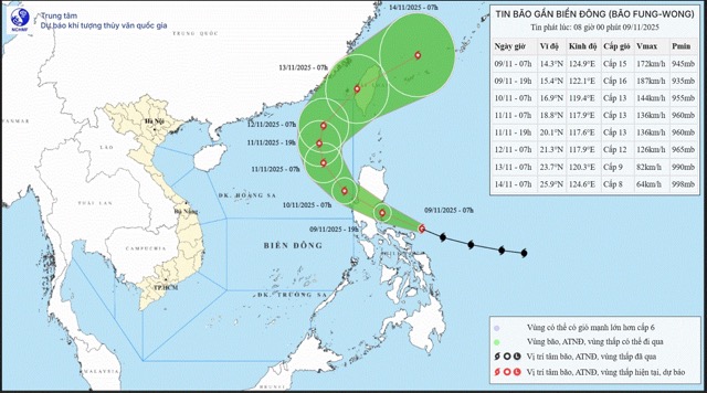
In the next 24 hours, the storm will move into the East Sea and become storm No. 14.
The storm is forecast to change direction and curve northeast for the next 1.5-3 days.
The storm is likely to make landfall in Taiwan (China) right before the 4th day of the forecast cycle, then gradually weaken.
The storm has been causing strong gusts of wind in many areas of Luzon Island. Some areas of Central and Northern Luzon.
The risk of storm surge of over 3m is warned in coastal provinces of the Philippines.
People and tourists are advised to stay away from coastal areas, breakwaters and frequent flooding.
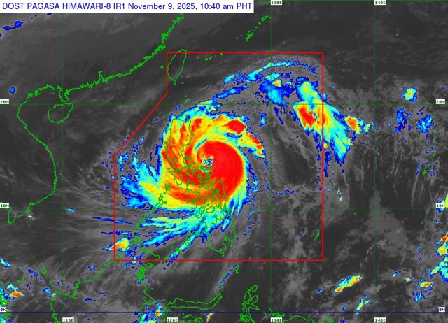
Rough seas with waves 6-14 m high in many areas around Luzon and Visayas. The Philippine Meteorological Agency recommends that all vessels - from small to large vessels - stay in port safely until the wind and waves have subsided.
Tourists should closely monitor warnings from local meteorological agencies and tour/hotel providers.
Avoid traveling by sea, island tourism or outdoor activities in affected areas.
Prepare a schedule change plan, especially if you are in Luzon or prepare to travel to Taiwan (China) and the Philippines.


