According to the latest storm information from the Joint Typhoon Warning Center (JTWC), storm No. 13 Kalmaegi (Philippine name: Tino, Japanese typhoon code: 25, is currently moving rapidly in a direction almost northwest at a speed of about 39 km/h, very rough seas with waves up to 9.1 m high.
The strongest wind speed of typhoon Kalmaegi reached 215 km/h, equivalent to a super typhoon level on the scale measured by Vietnam.
Storms can cause many dangers, including strong gusts of wind, heavy rain, storm surges, rough seas, landslides and flash floods - especially in coastal and mountainous areas.
The storm continues to move rapidly and heads straight towards the central coast of Vietnam, near the location of about 14.0 degrees North latitude - 109.0 degrees East longitude.
The forecast time for the storm to officially make landfall is around 7:00 p.m. today, November 6, because the storm moved very quickly when approaching the Quy Nhon coast.
From this evening to tonight, the storm will make landfall in Quang Ngai and Gia Lai. Compared to yesterday's storm forecast, storm No. 13 made landfall about 4 hours earlier.
Although the storm is expected to weaken slightly before making landfall due to stronger wind shear at the end of the road, the intensity when it reaches shore is still very strong, about 185 km/h.
After making landfall, storm No. 13 is forecast to weaken rapidly as it moves deeper into the mountainous terrain in the west of Central Vietnam.
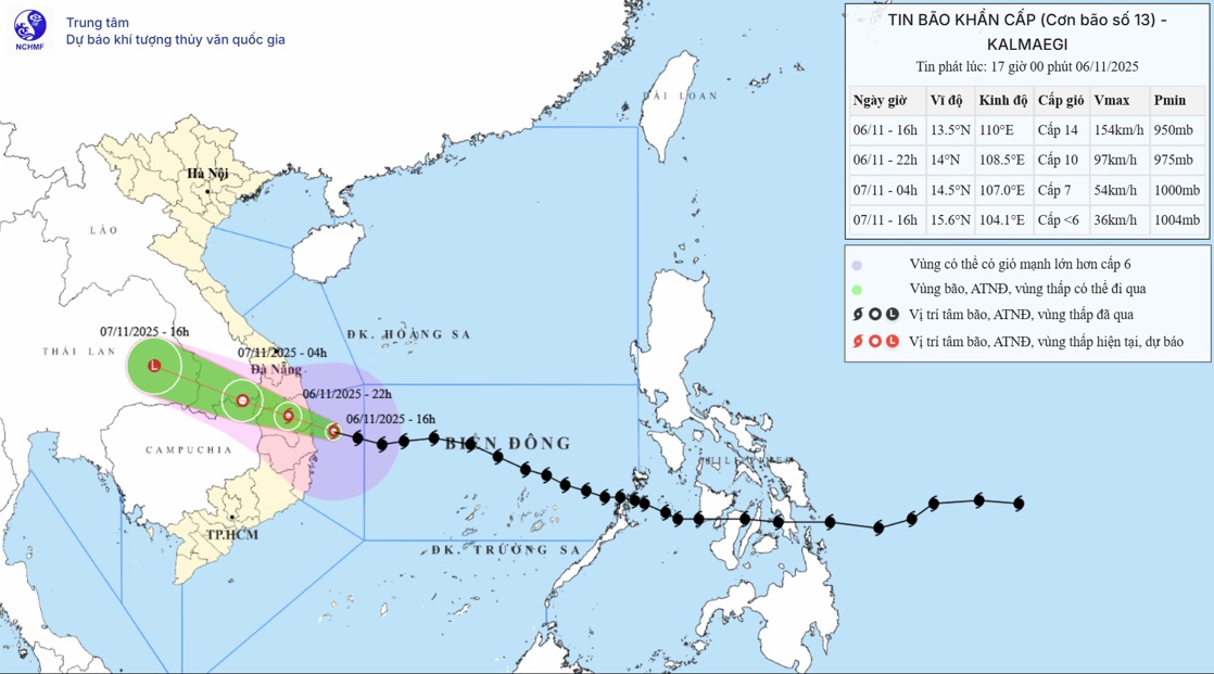
According to the storm information from the National Center for Hydro-Meteorological Forecasting, at 4:00 p.m. on November 6, the center of storm No. 13 Kalmaegi was at about 13.5 degrees North latitude; 110.0 degrees East longitude, about 90km East Southeast of Quy Nhon (Gia Lai).
Maximum wind speed: Level 14 (150-166km/h), gust level 17.
It is forecasted that in the next 3 hours, the storm will move mainly in the West Northwest direction, at a speed of about 30km/h. Intensity level 12-13.
Due to the impact of the storm, Ly Son Island (Quang Ngai) recorded strong winds of level 7, gusting to level 9; Dung Quat (Quang Ngai) had strong winds of level 6, gusting to level 8; Phu Cat (Gia Lai) had strong winds of level 7, gusting to level 10; Hoi An (Da Nang) had strong winds of level 8, gusting to level 9.
By 7:00 p.m. on November 6, the storm will move west-northwest at a speed of 25-30 km/h, the center of the storm is expected to be at about 13.8° North latitude; 109.4° East longitude, located in the coastal area from Quang Ngai to Dak Lak.
The storm intensity decreased to level 13, gusting to level 15. The area is located in the danger zone extending from latitude 11.50° North to 16.00° East and west of longitude 113.00° East.
The natural disaster risk level reached level 4 in the western part of the Central East Sea, the sea and mainland areas from Quang Ngai to Gia Lai, the north of Dak Lak; level 3 for the sea areas from South Quang Tri to Da Nang (including Cu Lao Cham), Khanh Hoa and part of the mainland of neighboring areas.
At 01:00 on November 7, the storm continued to move west-northwest at a speed of 25-30 km/h, moving deep into the mainland from Quang Ngai to Dak Lak and gradually weakening to level 8-9, gusting to level 11. The danger zone is maintained from latitude 11.50°N to 16.00°N and west of longitude 110.50°E. The natural disaster risk level remains the same as in the previous period.
By 1:00 p.m. on November 7, the storm weakened into a low pressure area when moving into the eastern area of Thailand, at about 15.4° North latitude; 105.1° East longitude, intensity below level 6. The area of risk of narrowing is also from latitude 12.50°N to 16.00°N, west of longitude 110.00°E, with a level 3 natural disaster risk for the sea area from South Quang Tri to Da Nang and Khanh Hoa, along with some mainland areas of Quang Ngai, Gia Lai, Dak Lak and Khanh Hoa.
The sea area west of the Central East Sea has strong winds of level 8-12, the area near the storm center has strong winds of level 13-15, gusts above level 17; waves 6-8m high, near the storm center 9-11m high, the sea is very rough. The coastal area from South Quang Tri to Khanh Hoa (including Ly Son and Cu Lao Cham) will have strong winds of level 7-8, then increase to level 9-12; the area near the storm center will have strong winds of level 13-15, gusting above level 17. The common waves are 4-7m, 8-10m near the center of the storm.
The coastal area from South Quang Tri to Dak Lak is likely to have water rising from 0.51.0m. The highest sea level is forecast to be recorded in Thuan An (1.0m), Son Tra (1.2m), Hoi An (1.3m), Dung Quat (1.5m), Quy Nhon (1.2m) and Tuy Hoa (1.1m). Risk of flooding, waves of dykes, and coastal erosion threatens low-lying areas and aquaculture areas.
From the afternoon of November 6, the area from South Da Nang to Dak Lak will have strong winds of level 6-7, increasing to level 8-9; the area near the storm center will have strong winds of level 10-13, gusting to level 15-16, concentrated in the East of Quang Ngai - Gia Lai and the North of Dak Lak.
The area from South Quang Tri to North Da Nang and North Khanh Hoa will have strong winds of level 6-7, gusting to level 8-9, strongest from the evening to the night of November 6. From the evening of the same day, the West of Quang Ngai to Gia Lai will have strong winds of level 6-7, the storm center will have strong winds of level 8-9, gusting to level 11.
From the afternoon of November 06 to 07.11, the area from Da Nang to Dak Lak will have rain of 200-400mm, locally over 600mm; Nam Quang Tri to Hue, Khanh Hoa and Lam Dong will have rain of 150-300mm, some places exceeding 450mm. From November 07 to 18, the area from North Quang Tri to Thanh Hoa will have rain of 50-150mm, locally over 200mm. Warning of heavy rain over 200mm/3 hours.
People and tourists in these areas should be on guard against a high risk of thunderstorms, tornadoes and strong gusts of wind before and during the storm's landfall.


