According to the latest typhoon information from the Joint Typhoon Warning Center (JTWC), Typhoon Fung-wong (Japan typhoon code: 26) is currently about 181 km east-northeast of Yap and is moving west-northwest at a speed of about 20 km/h. The sea is rough, with waves about 5.5 m high.
In the next three days, Fung-wong's main route will continue in the west-northwest direction, approaching the east coast of Luzon Island (Philippines).
The storm is forecast to make landfall in the southern Casiguran region of Aurora province, right after the three-day mark. The storm will then pass Luzon and is expected to enter the South China Sea in the next 84 hours.
It is forecasted that at the time of making landfall for the first time, the storm intensity could reach about 215 km/h - super typhoon level. When it enters the mountainous terrain of Luzon, the storm will rapidly weaken. Once returning to the East Sea, the possibility of strengthening again will be limited due to strong winds from the south.
When entering the East Sea, the storm is forecast to turn north, towards Taiwan (China).
Typhoon Fung-wong is expected to rapidly strengthen over the next two days, reaching about 185 km/h.
In terms of intensity, international forecast models also agree that the storm will strengthen in the next three days. The maximum intensity is forecast to range from about 185 km/h to 270 km/h depending on the model. After that, all showed a weakening trend.
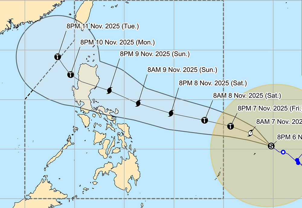
According to the typhoon forecast of the Philippine Atmospheric, Geophysical and Astronomical Services Administration ( pagasa), the typhoon is likely to enter the Philippine Area of Responsibility (PAR) from late Friday evening, November 7 to early Saturday morning, November 8. When entering PAR, the storm will be locally named Uwan.
The agency also warned that although the path is still uncertain, the risk of the storm making landfall in Northern Luzon or Central Luzon on Monday, November 10, is increasing.
Pagasa maintained that the storm could strengthen to super typhoon status on Saturday, November 8. The storm is likely to make landfall at near- malest intensity throughout the forecast period.
People and tourists should continue to monitor storm forecast updates.
From Sunday, November 9 onwards, many coastal areas around Luzon and eastern Visayas may experience very rough seas with dangerous high waves.


