According to the latest storm news from the Australian Bureau of Meteorology (BOM), Hurricane Narelle is one of the rare storms when moving through many areas before continuing to strengthen offshore.
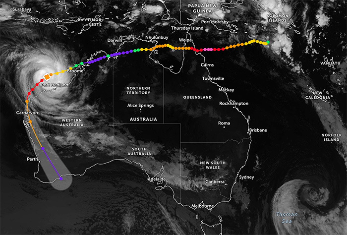
Super typhoon Narelle is the first typhoon system in 21 years to make landfall in three states and territories of Australia. Previously, the typhoon made landfall in Australia twice, weakening into a tropical depression and then strengthening into a storm when entering the sea.
Meteorologists say this is one of the strongest storms to have ever affected this area in decades. When it made landfall in northern Queensland, it was the biggest storm many people had ever witnessed in their lives.
Storm Narelle is forecast to strengthen to level 4 (according to BOM's storm level, equivalent to storm level 16-17 on the storm scale in Vietnam) when approaching the Exmouth area and moving along the West Australian coast. Recorded wind speeds up to 250-260 km/h, even gusts up to 275 km/h at some points, accompanied by very heavy rain.
The meteorological agency warns of "extremely devastating" winds accompanied by heavy rain that could cause widespread flash floods, especially in the Pilbara, Gascoyne and Central West areas.
Monitoring data shows rainfall up to nearly 200 mm at some offshore islands, while many areas record gusts over 200 km/h - a rare level in normal weather forecasts.
In Exmouth - a popular tourist destination - part of the roof of the evacuation center was blown away by the storm, showing the great destructive power of this system. Many buildings and houses had their roofs blown off, widespread power outages and flooding due to heavy rain.
According to the West Australian state emergency management agency, a series of roads were closed, more than 50 schools were suspended, many flights were canceled and tourist facilities were forced to temporarily stop picking up passengers.
Areas such as Coral Bay, Carnarvon, Denham and Geraldton are in the danger warning zone, requiring residents and tourists to stay indoors or leave the area if necessary.
According to the weather forecast, Typhoon Narelle is likely to make landfall in the area between Coral Bay and Carnarvon on March 27 with an intensity of about level 3, before gradually weakening when going deep into the mainland of Dongara, Western Australia.
However, this system continues to cause heavy rain and strong winds as it moves south, affecting the Perth area with forecast rainfall of 50-100 mm in two days.
The risk of localized flooding and flash floods is warned to last even after the storm weakens into a tropical depression.
The developments of Super Typhoon Narelle are causing major disruption to Western Australia's tourism industry right at the time of preparing to enter the peak season.
Many sea tours and coral diving activities in Ningaloo were canceled, hotels were closed and tourists were forced to change plans. Some tourist areas have completed evacuation, and all bookings have been canceled to ensure safety.
Tourists continuously follow storm forecasts and weather forecasts from authorities. Avoid moving to Western Australia during storm activity.
In the context of increasing extreme weather, experts recommend that tourists prioritize safety, update official information and limit moving into storm-affected areas.


