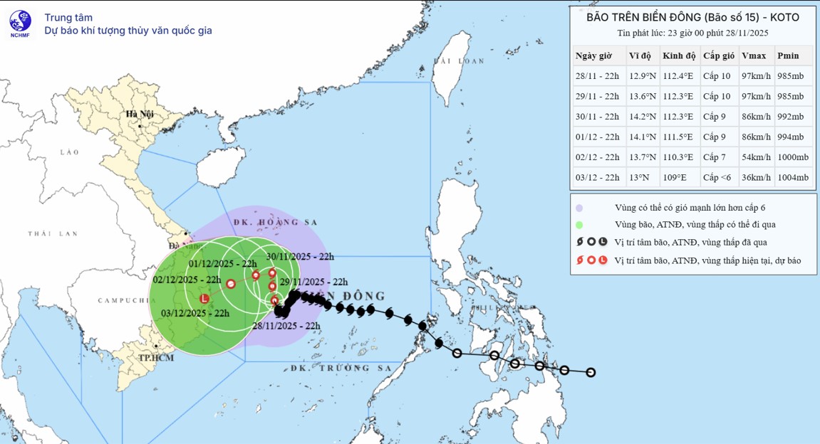
According to the tropical depression forecast from the National Center for Hydro-Meteorological Forecasting, this rare tropical depression is identified as a weakened circulation from Typhoon Senyar - the most strange storm in 2025.
This is a phenomenon that international meteorological agencies consider extremely unusual in the context of increasingly uncertain global storm forecasts due to climate change.

Senyar is one of the rarest storms ever recorded in the world. The storm formed on November 26 right in the Strait of Malacca, the coordinates near the equator, which has been considered a "storm-free zone" for more than 180 years.
Typhoon Senyar made landfall in Sumatra (Indonesia) with the strongest winds ever recorded in this area, passing through Malaysia and weakening into a low pressure area.
The depression did not disband but reorganized, strengthening into a tropical depression as it moved to eastern Malaysia - and is currently on its way to the East Sea.
The storm forecast shows that from November 29, the tropical depression from storm Senyar and storm No. 15 Koto will be in the East Sea.

According to the National Center for Hydro-Meteorological Forecasting, the tropical depression has the strongest winds of level 6-7 (39-61km/h), gusting to level 9, mainly northeast at a speed of about 15km/h.
It is forecasted that in the next 24-48 hours, the tropical depression will move southwest of the South China Sea and maintain an intensity of level 7, gusting to level 9.
In the next 48 to 72 hours, the tropical depression will continue to move north-northeast at a speed of 10-15km/h.
After entering the East Sea, the low pressure is likely to continue moving northeast and will hardly strengthen into a storm; by December 1, this system is expected to gradually weaken.
Meanwhile, Typhoon No. 15 Koto is still operating in a complex manner in the northwest of the Truong Sa archipelago, making the forecast of sea weather in the coming days more notable than ever.

The storm forecast for the next 1-2 days shows that storm No. 15 Koto will move north-northeast at a speed of about 5km/h and continue to weaken.
By November 30, storm No. 15 will change direction to west; on December 1, it will turn west-southwest, decreasing by about one level per day.
When approaching the sea off the coast of Quang Ngai - Dak Lak, storm No. 15 Koto is expected to weaken into a tropical depression and cause rain in the South Central region from November 30 to December 3.
In the face of complicated thunderstorms caused by storm No. 15 Koto and tropical depressions, people and tourists need to closely monitor weather forecasts and updated storm forecasts to ensure safety.
Responding to storm No. 15 Koto, Lam Dong banned all boat activities from 7:00 a.m. on November 28 and instructed vehicles to enter the storm shelter safely. The government focuses on protecting the coast, dams, dykes and production areas.
Khanh Hoa, Dak Lak, Gia Lai all ban the sea, require ships to take shelter from the storm and prepare evacuation plans. In Khanh Hoa alone, more than 200 fishing vessels with 2,500 fishermen took shelter in Truong Sa. Dak Lak plans to relocate nearly 23,000 people, Gia Lai controls more than 140 reservoirs.
Many sea tourism activities in An Giang from Phu Quoc to Nam Du and Hai Tai have been suspended to ensure safety.


