The tropical depression forecast to enter the East Sea may strengthen into storm No. 16.
The National Center for Hydro-Meteorological Forecasting is monitoring this tropical depression.
If the tropical depression strengthens over the East Sea to become storm No. 16, it is forecasted to move towards the Central Central - South Central region and cause moderate to heavy rain from Hue to Khanh Hoa.
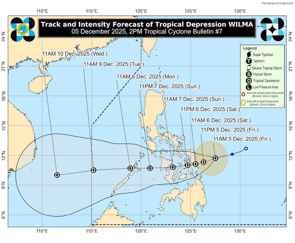
According to the latest low pressure forecast from the Philippine Atmospheric, Geophysical and Astronomical Services Administration (PAGASA), the tropical depression (local name: Wilma) is moving slowly as it approaches the Visayas region.
The tropical depression is about 225km east of Borongan (Eastern Samar), maintaining its intensity with winds of 45 km/h, gusting to 55 km/h.
The tropical depression is forecast to make its first landfall in the Eastern Visayas region tonight, December 5, or tomorrow, December 6, before continuing to sweep through the Visayas on December 7 and the Palawan region on December 8.
The tropical depression will maintain its intensity as it makes landfall in the Philippines, but PAGASA forecasts that the system will continue to strengthen as it enters the East Sea.
In the low pressure forecast information issued at 2:00 p.m. on December 5, the meteorological agency said Wilma will continue to move in the West Southwest direction at a speed of 10 km/h, creating a strong wind area extending up to 220 km from the center.
Many provinces in Luzon, Visayas and Mindanao are under a level 1 strong wind warning, which means there is a risk of gusts of wind and bad weather conditions that can directly affect tourists' travel, especially in coastal and mountainous areas.
Tropical depression forecast and rough seas warning show that many areas will see waves 4-5.5m high, making all maritime activities and island tours dangerous. Tourist boats, small boats and unqualified vehicles are advised not to leave port.
According to PAGASA's typhoon forecast, Wilma could enter Eastern Visayas between the evening of December 05 and the morning of December 6, then pass through Visayas until the end of December 07 before reaching the East Sea and is likely to strengthen.
In the context of unfavorable weather forecasts, visitors should pay attention to continuously updating low pressure forecasts, monitoring the movement direction of tropical depression Wilma and fully complying with local safety instructions.


