Tropical depression is likely to strengthen into storm No. 4, heavy rain is coming in the North

AN AN |

The meteorological agency forecasts that the tropical depression moving towards the Gulf of Tonkin is likely to strengthen into storm No. 4, with the risk of widespread and prolonged heavy rain in the North.

According to the National Center for Hydro-Meteorological Forecasting, the tropical depression is tending to strengthen and has many notable developments.

At 13:00 on August 20, the center of the tropical depression was located at about 19.5 degrees North latitude; 109.9 degrees East longitude, in the area north of Hainan Island (China). The strongest wind near the center of the tropical depression is strong at level 6 (39 - 49km/h), gusting at level 8. The tropical depression is moving in a West direction, speed 5 - 10km/h.

Ông Mai Văn Khiêm đã cung cấp thông tin dự báo về 2 kịch bản của áp thấp nhiệt đới. Ảnh: Vũ Linh
Mr. Mai Van Khiem provided forecast information about 2 scenarios of the tropical depression. Photo: Vu Linh

Mr. Mai Van Khiem - Director of the National Center for Hydro-Meteorological Forecasting said that it is forecast that around early tomorrow morning (August 21), the tropical depression will move into the Gulf of Tonkin area and is likely to strengthen into a storm, intensity level 8, gusts level 10.

Currently, the tropical depression is located on a trophic convergence zone. The axis of this trophic convergence zone passes through the area between the Southern Red River Delta and the North Central region. With the characteristic of maintaining activity on the trophic convergence zone, moving slowly, while the large-scale flow field and interaction with surrounding weather systems are still changing.

Therefore, forecasting models to date still have a certain dispersion in terms of trajectory, intensity and area of direct impact on land. According to current data, there are 2 main groups of disaster risk scenarios" - Mr. Khiem said.
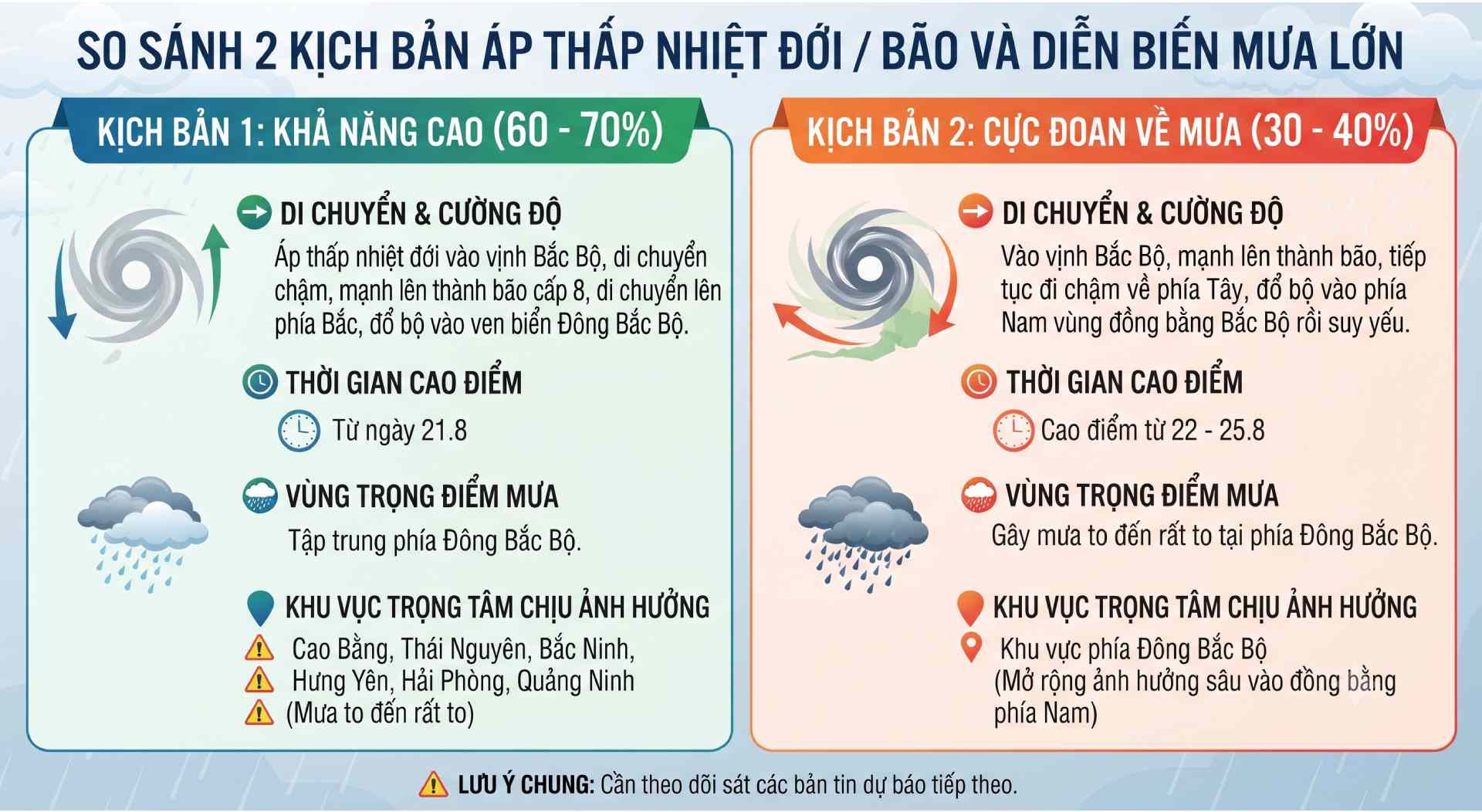
So sánh 2 kịch bản diễn biến áp thấp nhiệt đới. Ảnh: Có sử dụng AI
Comparing 2 scenarios of tropical depression developments. Photo: AI used

According to a representative of the meteorological agency, scenario 1 is a scenario with a high probability of about 60 - 70%. The tropical depression after entering the Gulf of Tonkin moves slowly, with the possibility of strengthening into a level 8 storm, moving north and making landfall in the coastal area of the Northeast region.

This scenario will cause heavy rain in the North to increase again from August 21st and concentrate in the eastern region of the North, including Cao Bang, Thai Nguyen, Bac Ninh, Hung Yen, Hai Phong, Quang Ninh areas with heavy to very heavy rain" - Mr. Khiem analyzed.

The Director of the National Center for Hydro-Meteorological Forecasting added that scenario 2 is the extreme possibility of rain, with a probability of about 30 - 40%.

According to scenario 2, after entering the Gulf of Tonkin and strengthening into a storm, the tropical depression/storm will continue to move slowly to the west and make landfall in the southern area of the Northern Delta and then weaken. This scenario will cause heavy to very heavy rain in the eastern North, peaking from August 22 - 25" - Mr. Khiem provided forecast information.

According to Mr. Mai Van Khiem, these scenarios will continue to change when the tropical depression moves deep into the Gulf of Tonkin in the next 1-2 days. Therefore, it is necessary to pay attention to monitoring the developments of the tropical depression, the situation of natural disasters, strong winds, and thunderstorms in the East Sea in the next bulletins of the Hydrometeorological agency.

AN AN
RELATED NEWS

Forecast of heavy rain in provinces and cities, with very heavy rain in some places over 250mm

|

This evening, August 20, the area from Thanh Hoa to Ha Tinh continues to have widespread heavy rain. From near dawn on August 21, rain will increase again in the Northeast region.

Tropical depression is likely to strengthen into a storm in the next 24 hours

|

Forecast for the next 24 hours, the tropical depression will move in a West-Northwest direction, enter the Gulf of Tonkin and is likely to strengthen into a storm.

Forecast for the area to have prolonged heavy rain, with very heavy rain in some places

|

From near dawn on August 21, the Northeast region will have moderate rain, heavy rain and thunderstorms, locally very heavy rain in some places. It is forecast that this rain wave is likely to last.

Proposal to reduce 30% tax for businesses with revenue under 10 billion VND

|

The Government proposes a 30% reduction in personal income tax and corporate income tax for business households and businesses with revenue below 10 billion VND.

Heavy rain and tornadoes caused an ancient tree to fall and hit a truck moving on Deo Chuoi Pass

|

Lam Dong - Heavy rain accompanied by tornadoes caused many forest trees and green trees to be uprooted and fallen on National Highway 20, including an ancient tree falling on a truck on Deo Chuoi Pass.

Verifying information on 170 Vietnamese citizens detained in Pakistan

|

The Vietnamese Embassy in Pakistan is coordinating with local authorities to verify information related to 170 Vietnamese citizens being temporarily detained in this country.

Iran plans to ban hostile ships from passing through the Strait of Hormuz

|

Iran is considering a plan to collect tolls and fine ships through the Strait of Hormuz.

Forecast of heavy rain in provinces and cities, with very heavy rain in some places over 250mm

AN AN |

This evening, August 20, the area from Thanh Hoa to Ha Tinh continues to have widespread heavy rain. From near dawn on August 21, rain will increase again in the Northeast region.

Tropical depression is likely to strengthen into a storm in the next 24 hours

AN AN |

Forecast for the next 24 hours, the tropical depression will move in a West-Northwest direction, enter the Gulf of Tonkin and is likely to strengthen into a storm.

Forecast for the area to have prolonged heavy rain, with very heavy rain in some places

AN AN |

From near dawn on August 21, the Northeast region will have moderate rain, heavy rain and thunderstorms, locally very heavy rain in some places. It is forecast that this rain wave is likely to last.
