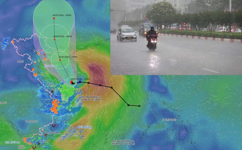
Early in the morning of July 3, the tropical depression strengthened into storm No. 1 of 2026, international name Maysak. According to the Dispatch of the National Steering Committee for Civil Defense, at 4:00 AM on July 3, the storm's center was located at about 17.3 degrees North latitude, 110.1 degrees East longitude, over the sea area in the Northwest of the Hoang Sa special zone. Storm intensity is strong at level 8, gusts at level 10.
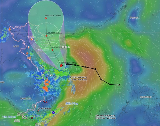
It is forecasted that storm No. 1 will move into the Gulf of Tonkin and affect the Northeast region in the coming days. From the night of July 3rd to the end of July 5th, the Northeast and Thanh Hoa regions are likely to experience heavy rain, commonly 100-200mm; especially the Northeast region 150-250mm, locally over 350mm.
To proactively respond to storms and floods after storms, the National Steering Committee for Civil Defense requests the People's Committees of provinces and cities (Quang Ninh, Hai Phong, Hung Yen, Ninh Binh, Thanh Hoa, Lang Son, Cao Bang, Ha Giang, Bac Ninh, Thai Nguyen, Hanoi) and relevant ministries and sectors to urgently implement measures to ensure safety for people, ships, coastal works and areas at risk of flooding and landslides.
For the sea route, localities continue to organize counting, notify vehicle owners and captains of ships and boats operating at sea of the storm's location, direction of movement and developments to proactively prevent and escape from dangerous areas or return to safe shelters.
Localities are also required to inspect and guide the anchoring of ships and boats in the anchorage area; deploy safety assurance for people, vehicles, and property, especially at tourist destinations, aquaculture and fishing areas, sea and island works and coastal areas forecast to be affected by storms.
Based on the specific situation, localities proactively decide on sea bans. At the same time, be ready with forces and means for rescue and relief when requested.
For the delta area, the National Steering Committee for Civil Defense proposes to review and be ready to evacuate people from unsafe houses, areas at risk of deep flooding, river mouths, and coastal areas. Localities need to ensure the safety of sea dikes and river mouth dikes, especially in key or under construction locations.
The telegram also requests to proactively drain buffer water and prevent waterlogging to protect agricultural production, urban areas and industrial parks at risk of flooding; organize pruning of tree branches, reinforcing and reinforcing signboards, houses, public works, industrial parks, factories, warehouses and projects under construction.
Functional units need to inspect, review, and take measures to ensure the safety of the telecommunications system and power grid to maintain stable operation, without interruption before, during and after the storm.
For mountainous areas, localities deploy shock forces to inspect, review, and proactively relocate and evacuate people in riverside, stream, low-lying areas, areas at risk of deep flooding, flash floods, and landslides to safe places.
The Steering Committee also requested to clear the flow in the congested areas, and prepare on-site forces to promptly support people to overcome the consequences if incidents occur.
Localities need to organize forces to guard, control, and guide traffic safety at underground, spillway, deeply flooded roads, fast-flowing water, areas where landslides have occurred or are at risk of landslides; resolutely not allowing people and vehicles to pass if safety is not ensured.
In addition, localities must inspect, review, and implement measures to ensure the safety of tunnels, mineral exploitation furnaces, reservoirs and downstream areas, especially small hydropower reservoirs, small irrigation, and key reservoirs; arrange on-duty forces to operate regulation and be ready to handle arising situations.