The National Center for Hydro-Meteorological Forecasting has provided forecast information on rain developments in some areas across the country.
On July 3rd day and night, it is forecast that the area from Nghe An to Dak Lak will have showers and scattered thunderstorms with rainfall of 15 - 30mm, locally very heavy rain over 100mm. In thunderstorms, there is a possibility of tornadoes, lightning, hail and strong gusts of wind.
The Southern region and Lam Dong have rain, moderate rain and scattered thunderstorms with rainfall of 10 - 30mm, locally heavy rain over 70mm.
Northeast and Thanh Hoa are the focus areas of heavy rain
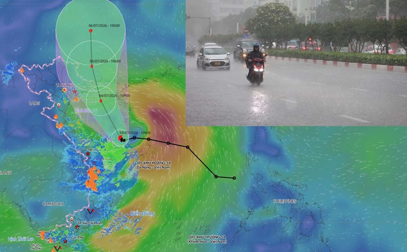
Forecast from tonight July 3rd, storm No. 1 will cause rain in many places in the Northern region.
From the night of July 3rd to the night of July 4th, the Northeast region and Thanh Hoa will have moderate rain, heavy rain and thunderstorms with common rainfall of 70 - 150mm, locally very heavy rain over 200mm. (In which, the Northeast region includes Hanoi city, Tuyen Quang, Cao Bang, Thai Nguyen, Lang Son, Quang Ninh, Hai Phong city, Bac Ninh, Hung Yen, Ninh Binh, the northern area of Phu Tho province (Vinh Phuc and former Phu Tho provinces)).
Warning of the risk of heavy rain with rainfall greater than 100mm/3 hours. Disaster risk level warning due to heavy rain, tornadoes, lightning, and hail is level 1.
On July 5th day and night, the Northeast region will have moderate rain, heavy rain and thunderstorms with common rainfall of 30 - 60mm, especially the Northeast region 50 - 100mm, locally over 180mm.
Regarding rainfall for the whole period, it is forecast that from the night of July 3rd to the end of July 5th, the Northeast region and Thanh Hoa will have a common total rainfall of 100-200mm; especially the Northeast region 150-250mm, locally over 350mm.
Risk of flooding on rivers in the Northeast region
Regarding the hydrological situation, currently, the water level on the main rivers of the Red River-Thai Binh river system has small fluctuations and is below alarm level 1.
From July 4th to July 7th, a flood is likely to appear on rivers in the Northeast region, the flood amplitude upstream of rivers from 3-6m, downstream of rivers from 2 - 4m.
During this flood, the peak flood on the Lo River, upstream of the Thai Binh River and rivers in Quang Ninh, Lang Son, Cao Bang and Bac Ninh provinces are likely to reach alarm level 1-alerte level 2, with some rivers above alarm level 2; downstream of the Red River, Thai Binh River and Lo River are below alarm level 1.
High risk of flooding in low-lying areas along rivers, urban areas in the Northern Delta; flash floods, landslides on slopes in mountainous and midland provinces in the Northern Delta region.
Warning level of natural disaster risk due to floods is level 1.
Floods on rivers and streams can cause flooding in low-lying areas along rivers, affecting activities such as waterway traffic, aquaculture, agricultural production, people's livelihoods and socio-economic activities.