The latest update from the National Center for Hydro-Meteorological Forecasting, at 1:00 p.m. on October 3, the center of the storm was at about 16.8 degrees north latitude; 121 degrees east longitude, on the mainland north of Luzon Island (Philippines). The strongest wind near the storm center is level 9-10 (75-102 km/h), gusting to level 13. The storm is moving west-northwest at a speed of about 25 km/h.
It is forecasted that in the next 24 hours, the storm will move west-northwest, at a speed of about 25 km/h, entering the East Sea and is likely to strengthen.

According to Mr. Mai Van Khiem - Director of the National Center for Hydro-Meteorological Forecasting, Department of Hydro-Meteorology, it is forecasted that around the evening of October 3, storm Matmo will overcome the northern area of Luzon Island (Philippines) into the East Sea and become the 11th storm in the East Sea in 2025.
At 1:00 p.m. on October 4, the center of the storm was at about 18.4 degrees north latitude; 115 degrees east longitude, in the northern East Sea, about 480 km east-southeast of the Lusian Peninsula (China). Strong winds of level 11-12, gusts of level 15 - an increase of about 2 levels compared to the present.
Explaining the reason for the increase in level, according to Mr. Mai Van Khiem, it is forecasted that after moving into the East Sea, the sea surface temperature will be relatively favorable (about 29 degrees Celsius), the wind shear in the northern area of the East Sea (where the center of storm Matmo moves in) will be small, favorable for the development of the storm.
" Meanwhile, the subtropical high pressure, the shape that determines the speed of movement in the direction of storm Matmo, will encroach strongly to the west, causing storm Matmo to strengthen and move rapidly (average from 25-30km/h)" - Mr. Khiem analyzed.
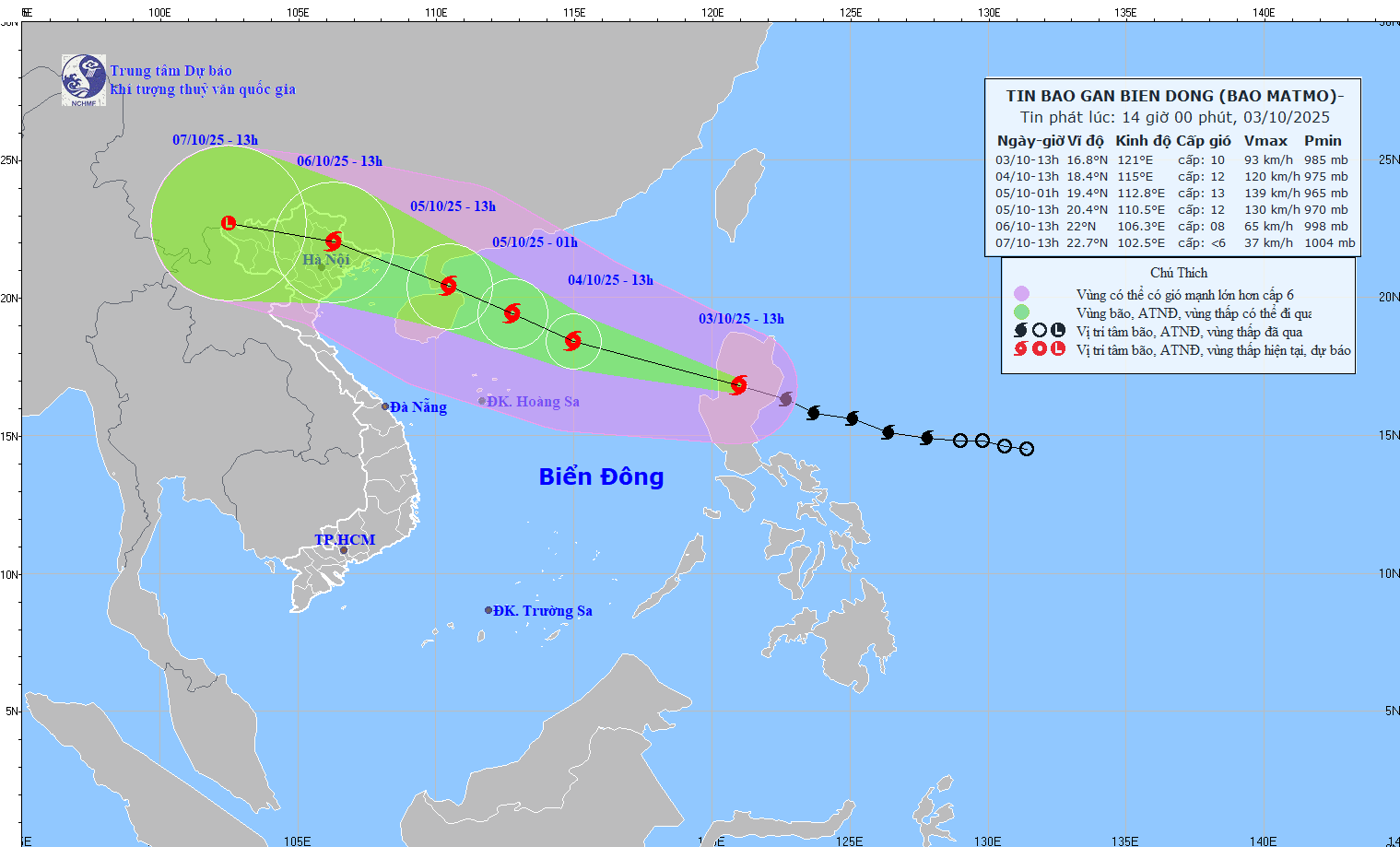
It is forecasted that in the next 48 hours, the storm will move west-northwest, at a speed of about 20-25 km/h and will continue to strengthen. At 1:00 p.m. on October 5, the center of the storm was at about 20.4 degrees north latitude; 110.5 degrees east longitude, in the southern coastal area of Zhou Peninsula (China), about 330 km east-southeast of Mong Cai ( guangning). Strong wind level 12, gust level 15.
The danger zone is north of the 17-degree north latitude, from the 108 degrees east longitude to the 117 degrees east longitude. Level 3 natural disaster risk in the northern East Sea and the northern waters of the Gulf of Tonkin.
It is forecasted that in the next 72 hours, the storm will move west-northwest, at a speed of about 20 km/h, entering the northern area of the Gulf of Tonkin and gradually weakening.
At 1:00 p.m. on October 6, the center of the storm was at about 22 degrees north latitude; 106.3 degrees east longitude, on the mainland of the Northeast region. Strong wind level 8, gust level 10.
The danger zone is north of latitude 18 degrees north, west of longitude 112.5 degrees east. Level 3 natural disaster risk in the northwestern sea area of the northern East Sea, the northern area of the Gulf of Tonkin and coastal areas of provinces from Quang Ninh to Ninh Binh.
In the next 72 to 96 hours, the storm will move west-northwest, traveling about 15 km/h, moving deep into the mainland and gradually weakening into a tropical depression, then a low pressure area.
The director of the meteorological agency emphasized that the storm's mobility is likely to change as the storm moves into the East Sea (the storm scenarios will be clearer). Therefore, information about the trajectory and intensity of storm Matmo will be continuously updated.
Regarding the impact of the storm at sea, the sea area east of the northern East Sea will have winds gradually increasing to level 6-7, then increasing to level 8-9, the area near the storm's eye will have strong winds of level 10-11, gusts of level 14, waves 4-6 m high, and rough seas.
"From October 4, the northern East Sea area will have strong winds of level 8-10, the area near the storm center will have winds of level 11-13, gusts of level 16, waves 4-6 m high, the area near the storm center will have waves of 6-8 m, the sea will be very rough" - Mr. Khiem warned.
Ship operating in the above-mentioned dangerous areas are likely to be affected by thunderstorms, whirlwinds, strong winds and large waves.