The latest update from the National Center for Hydro-Meteorological Forecasting, at 7:00 p.m. on October 2, the center of storm Matmo was at about 15.6 degrees north latitude; 125.1 degrees east longitude, in the sea east of the Philippines. The strongest wind near the storm center is level 8 - 9 (62 - 88 km/h), gusting to level 11. The storm is moving west-northwest at a speed of about 25 km/h.

According to Mr. Mai Van Khiem - Director of the National Center for Hydro-Meteorological Forecasting, in the next 24 hours, the storm is forecast to move west-northwest, at a speed of about 25 km/h.
At 7:00 p.m. on October 3, the center of the storm was at about 17.6 degrees north latitude; 120.1 degrees east longitude, in the sea west of Luzon Island (Philippines). Strong wind level 9, gust level 11.
The danger zone in the next 24 hours will be east of the 118-degree longitude, from 16 to 19.5 degrees north latitude. The natural disaster risk level is level 3 for the eastern sea area of the northern East Sea.
"It is forecasted that around the night of October 3, Typhoon Matmo will move into the East Sea and become the 11th storm of the year. Then the storm continues to move west-northwest at a fairly fast speed of about 25 - 30km/h, towards the Gulf of Tonkin" - Mr. Khiem said.
It is forecasted that in the next 48 hours, the storm is likely to strengthen. At 7:00 p.m. on October 4, the center of the storm was at about 18.9 degrees north latitude; 115.1 degrees east longitude, in the northern East Sea, about 420 km northeast of the Hoang Sa special zone. Strong wind level 11, gust level 13.
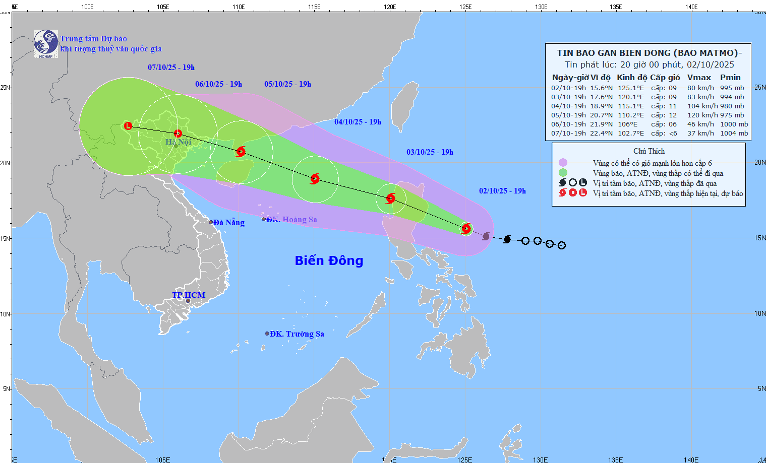
The dangerous area in the next 48 hours will be east of the 113-degree longitude, from 16.5 to 21 degrees north latitude. Natural disaster risk level: level 3, the northern sea area of the northern East Sea.
It is forecasted that in the next 72 hours, the storm will move west-northwest, at a speed of 20 - 25 km/h and is likely to strengthen. The center of the storm is located at about 20.7 degrees north latitude; 110.2 degrees east longitude, on the Lusian Peninsula (China). Strong wind level 11 - 12, gust level 15.
The dangerous area in the next 72 hours will be north of latitude 17.5 degrees north, from 108 to 117.5 degrees east. The natural disaster risk level is level 3 for the northern sea area of the North East Sea and the northern area of the Gulf of Tonkin.
In the next 72 to 120 hours, the storm will move west-northwest, traveling 15 - 20 km per hour, and the storm intensity will gradually decrease.
According to the Director of the meteorological agency, due to the impact of storm Matmo, from noon and afternoon of October 3, the sea area east of the northern East Sea will have winds gradually increasing to level 6 - 7; then increasing to level 8 - 9, the area near the storm's eye will have strong winds of level 10 - 11, gusts of level 13, waves 4 - 6 m high, and rough seas.
"Around October 4 - 5, the sea area north of the northern East Sea is likely to be affected by strong winds of level 11 - 12, gusting to level 15. Ship operating in dangerous areas are likely to be affected by thunderstorms, whirlwinds, strong winds, and large waves" - Mr. Khiem warned.