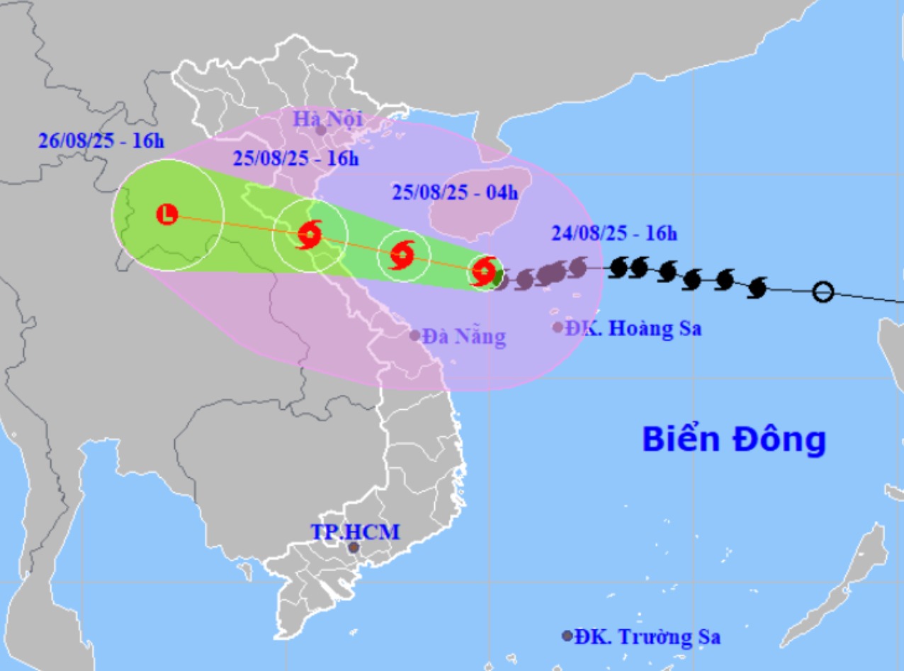
According to the National Center for Hydro-Meteorological Forecasting, at 4:00 p.m. on August 24, the center of storm No. 5 was at about 17.6 degrees north latitude; 109.9 degrees east longitude, about 470km from Nghe An, about 450km east-southeast of Ha Tinh, about 390km east of northern Quang Tri.
The strongest wind near the storm center is level 13-14 (134-166km/h), gusting to level across; moving west at a speed of about 20km/h and is likely to strengthen.
Storm No. 5 is likely to strengthen
According to Mr. Hoang Phuc Lam - Deputy Director of the National Center for Hydro-Meteorological Forecasting, in the evening and night of August 22, when it first entered the East Sea, it was at the tropical depression level, late level 6, early level 7, and strengthened into a storm by the morning of August 23 until the afternoon of August 24, then strengthened to level 13 - 14.
"Thus, in just 2 days, the storm has strengthened by 7 levels" - Mr. Lam emphasized.
It is forecasted that in the next 12 hours, the storm will move west-northwest at a speed of about 20km/h.
At 4:00 a.m. on August 25, the center of the storm was at about 18.0 degrees north latitude; 107.9 degrees east longitude, in the southern sea of the Gulf of Tonkin, about 240km from Nghe An, about 210km east-southeast of Ha Tinh, about 140km east-northeast of Quang Tri. Strong winds of level 13-14, gusting to level 16.
The danger zone is from 16 to 20 degrees north latitude; west of the 112 degrees east longitude. Level 3 natural disaster risk for the western sea area of the northern East Sea (including Hoang Sa special zone), the Gulf of Tonkin, the southern sea area of Quang Tri - Hue city (including Hon Ngu island, Con Co special zone). Level 4 natural disaster risk: coastal waters from Thanh Hoa to Quang Tri.
Mr. Lam said that around noon and afternoon tomorrow, the center of the storm is likely to make landfall in the provinces from Thanh Hoa to North Quang Tri.
It is forecasted that in the next 24 hours, the storm will continue to move west-northwest at a speed of about 20km/h. At 4:00 p.m. on August 25, the center of the storm was at about 18.5 degrees north latitude; 105.6 degrees east longitude, on the mainland of the provinces from Thanh Hoa to Quang Tri. Strong winds of level 11-12, gusting to level 14.
The danger zone is from 16 to 20 degrees north latitude; west of the longitude 110 degrees east longitude. Level 3 natural disaster risk for the Gulf of Tonkin, the southern sea area of Quang Tri - Hue (including Hon Ngu island, Con Co special area). Level 4 natural disaster risk is the coastal waters from Thanh Hoa to Quang Tri, mainland provinces from Thanh Hoa to northern Quang Tri.
By 4:00 p.m. on August 26, the storm moved west-northwest at a speed of 15-20km/h and gradually weakened. The center is located at about 19 degrees north latitude; 102.1 degrees east longitude, in the central Laos area. Strong winds below level 6.
On land near the center of the storm, wind gusts of level 14-15
At sea, the sea area west of the northern East Sea (including Hoang Sa special zone) has strong winds of level 9-11, near the center of the storm level 12-14, gusts of level 16, waves 5.0-7.0m high, near the center of the storm 8.0-10.0m, the sea is very rough. The sea area from Thanh Hoa to Hue City (including Hon Ngu Island, Con Co special area) will have strong winds of level 7-9, then increase to level 10-11, the area near the storm's eye will have levels 12-14, gusts of level6; waves 5.0-4.0m high, the area near the storm's eye will have 8.0-10.0m, the sea will be very rough. The northern Gulf of Tonkin (including the special areas of Cat Hai, Co To, Van Don) will have winds gradually increasing to level 6-7, gusting to level 9; In the south, the northern area of the Gulf of Tonkin (including the special area of Bach Long Vi) will have strong winds of level 8-9, gusting to level 11; waves are 2.5-4.5m high, the sea is very rough.
On land, from the night of August 24, on land from Thanh Hoa to Quang Tri, the wind will gradually increase to level 8-10, near the storm center level 11-13, gusting to level 14-15; coastal areas from Quang Ninh to Ninh Binh, the wind will gradually increase to level 6-8, gusting to level 9.
From the evening of August 24 to the end of August 26, in the midlands and deltas of the northern region, the Lao Cai area and from Thanh Hoa to Hue City, there will be widespread heavy rain with common rainfall of 100-150mm, locally over 250mm; Thanh Hoa to northern Quang Tri will have heavy to very heavy rain with common rainfall of 200-400mm, locally over 700mm. Warning of the risk of heavy rain with rainfall of over 200mm within 3 hours
From the evening of August 24 to August 26, the Hanoi capital will have moderate rain, heavy rain and thunderstorms. On the night of August 24 and August 25, Da Nang City will have rain, moderate rain and thunderstorms. From the evening of August 24 to August 26, Ho Chi Minh City will have rain, showers and thunderstorms (thunderstorms will be concentrated in the afternoon and evening). During thunderstorms, it is necessary to be on guard against the risk of tornadoes and strong gusts of wind.
From August 25-27, the upper and middle areas of Laos will have heavy rain with common rainfall of 100-250mm, with some places in the middle Laos having over 500mm.