Storm No. 8 Mitag with gusts of level 11 is about to make landfall in the next 24 hours, forecasting bad weather

AN AN |

According to the meteorological agency, storm No. 8 Mitag will make landfall in Guangdong province (China) in the next 24 hours.

According to the National Center for Hydro-Meteorological Forecasting, at 4:00 a.m. on September 19, the center of storm No. 8 was at about 21.5 degrees north latitude; 116.1 degrees east longitude, in the northern sea area of the North East Sea, about 240km east-southeast of Hong Kong (China).

Cap nhat hoi 5 gio ngay 19.9 ve vi tri va duong di cua bao so 8. Nguon: Trung tam Du bao Khi tuong Thuy van Quoc gia
Updated at 5:00 a.m. on September 19 about the location and path of storm No. 8. Source: National Center for Hydro-Meteorological Forecasting

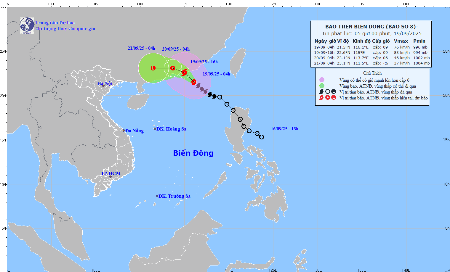
The strongest wind near the storm center is level 8-9 (62-88km/h), gusting to level 11. The storm is moving northwest at a speed of about 15km/h.

Mr. Nguyen Van Huong - Head of Weather Forecast Department, National Center for Hydro-Meteorological Forecasting warned of the impact of the circulation after storm No. 8.

Mr. Nguyen Van Huong - Head of Weather Forecast Department, National Center for Hydro-Meteorological Forecasting said that in the next 12 hours, the storm is forecast to move northwest, at a speed of about 15km/h.

At 4:00 p.m. on September 19, the center of the storm was at about 22.6 degrees north latitude; 115.0 degrees east longitude, in the southern coastal area of Guangdong province (China). Strong winds of level 8 - 9, gusting to level 11.

The danger zone is from the north of the latitude of 20 degrees north; from longitude 113 to 118 degrees east. The natural disaster risk level is level 3, the northern sea area of the North East Sea.

Ong Nguyen Van Huong - Truong phong Du bao Thoi tiet, Trung tam Du bao Khi tuong Thuy van Quoc gia cho biet, du bao hoan luu hau bao co the gay mua dong o mien Bac dau tuan toi. Anh: An An
Mr. Nguyen Van Huong - Head of Weather Forecasting Department, National Center for Hydro-Meteorological Forecasting said that the post-storm circulation is forecast to cause thunderstorms in the North early next week. Photo: An An

"It is forecasted that in the next 24 hours, the storm will move west-northwest at a speed of 10-15km/h, making landfall in Guangdong province (China) and gradually weakening into a tropical depression" - Mr. Huong said.

At 4:00 a.m. on September 20, the center of the tropical depression was at about 23.1 degrees north latitude; 113.7 degrees east longitude, on the mainland south of Quang Dong province. Strong wind level 6, gust level 8.

The danger zone is from the north of the latitude of 21.5 degrees north; from the longitude of 113 to 117 degrees east. The natural disaster risk level is level 3, the northern sea area of the North East Sea.

It is forecasted that in the next 48 hours, the tropical depression will continue to move westward at a speed of about 10km/h, moving deep into the mainland and weakening into a low pressure area. At 4:00 a.m. on September 21, the center of the low pressure area was at about 23.1 degrees north latitude; 111.5 degrees east longitude, on the mainland southwest of Guangdong province (China). Wind intensity below level 6.

"So it is unlikely that storm No. 8 will directly affect the mainland of Vietnam. However, due to the influence of the storm circulation in the northern sea area of the North East Sea, there will be strong winds of level 6 - 7, gusting to level 9; The area near the storm's center will have strong winds of level 8 - 9, gusting to level 11. The waves are 3-5m high, the sea is very rough" - Mr. Huong analyzed.

Ship operating in the danger zone are likely to be affected by thunderstorms, whirlwinds, strong winds and large waves.

"We believe that after weakening into a low pressure area on mainland China, this low pressure area is likely to move gently towards our country, causing a widespread thunderstorm in the Northern provinces from September 23 to 24" - Head of the Weather Forecast Department warned.

AN AN
RELATED NEWS

Storm No. 8 Mitag is about to strengthen to level 11, warning of dangerous impacts

|

Due to the influence of storm No. 8 Mitag, the northeastern sea area of the northern East Sea near the center of the storm is forecast to have gusts of level 11, the sea will be very rough.

Storm No. 8 Mitag is about to strengthen, forecast time to cause heavy thunderstorms in the North

|

Although Typhoon No. 8 Mitag does not directly affect the mainland of Vietnam, the post-typhoon circulation is likely to cause widespread thunderstorms in the North.

Tropical depression is about to strengthen into storm No. 8, forecast time and area of landfall

|

According to the representative of the meteorological agency, today, September 18, the tropical depression is likely to strengthen into a storm and make landfall in Guangdong (China) around the afternoon and night of tomorrow.

Online seminar: " needs to be a direct dialogue to understand the correct about electricity bills"

|

On September 19, Lao Dong Newspaper organized a seminar: " needs to be a frank dialogue to understand the correct understanding of electricity bills", to clarify the reasons for the increase in electricity bills, and at the same time make recommendations for saving and using electricity safely and effectively.

Ruben Amorim faces the possibility of being sacked by Man United

|

According to commentator Quang Tung, coach Ruben Amorim is likely to be fired if he does not get good results in the next few rounds.

Resolution 72: Increase allowances, increase treatment policies for doctors and medical staff

|

According to Associate Professor, Dr. Dao Xuan Co - Director of Bach Mai Hospital, one of the breakthroughs of Resolution 72 is the increase in treatment policies for doctors and medical staff.

South Korea suspends all 7 generals of the counterpartition unit for Military policy

|

Three more generals of the South Korean National Defense Intermediary Command were suspended from work on September 18 for alleged martial law.

Storm No. 8 Mitag is about to strengthen to level 11, warning of dangerous impacts

AN AN |

Due to the influence of storm No. 8 Mitag, the northeastern sea area of the northern East Sea near the center of the storm is forecast to have gusts of level 11, the sea will be very rough.

Storm No. 8 Mitag is about to strengthen, forecast time to cause heavy thunderstorms in the North

AN AN |

Although Typhoon No. 8 Mitag does not directly affect the mainland of Vietnam, the post-typhoon circulation is likely to cause widespread thunderstorms in the North.

Tropical depression is about to strengthen into storm No. 8, forecast time and area of landfall

AN AN |

According to the representative of the meteorological agency, today, September 18, the tropical depression is likely to strengthen into a storm and make landfall in Guangdong (China) around the afternoon and night of tomorrow.