Storm No. 8 Mitag is about to strengthen to level 11, warning of dangerous impacts

AN AN |

Due to the influence of storm No. 8 Mitag, the northeastern sea area of the northern East Sea near the center of the storm is forecast to have gusts of level 11, the sea will be very rough.

According to the National Center for Hydro-Meteorological Forecasting, at 4:00 p.m. on September 18, the center of the storm was at about 20.1 degrees north latitude; 117.9 degrees east longitude, in the northeastern sea of the North East Sea, about 480km southeast of Hong Kong (China).

The strongest wind near the storm center is level 8 (62-74km/h), gusting to level 10. Moving northwest, speed 15-20km/h.
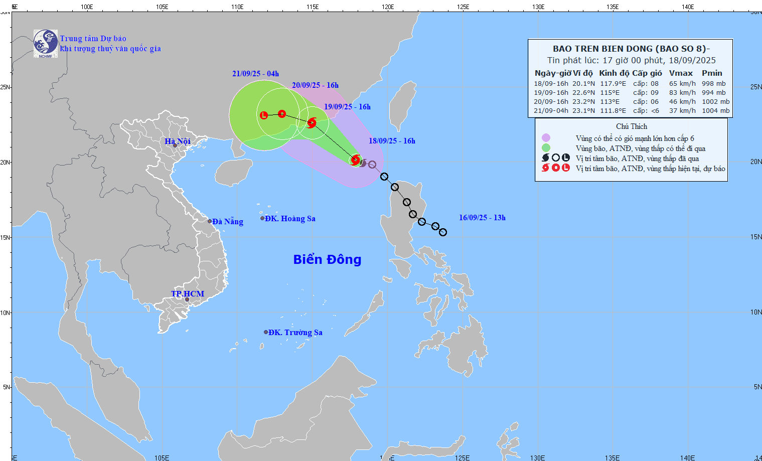
Cap nhat hoi 16 gio ngay 18.9 ve vi tri va duong di cua bao so 8. Nguon: Trung tam Du bao Khi tuong Thuy van Quoc gia
Updated at 4:00 p.m. on September 18 about the location and path of storm No. 8. Source: National Center for Hydro-Meteorological Forecasting

It is forecasted that in the next 24 hours, the storm will move northwest at a speed of about 15km/h and will continue to strengthen.

At 4:00 p.m. on September 19, the center of the storm was at about 22.6 degrees north latitude, 115 degrees east longitude, in the southern coastal area of Guangdong province (China). The strongest wind near the storm center is level 9, gusting to level 11.

The dangerous area in the next 24 hours will be identified as the north of the latitude of 18.5 degrees north latitude and east of the longitude of 113 degrees east longitude. Level 3 natural disaster risk, the affected area is the northeastern sea area of the North East Sea.

It is forecasted that in the next 48 hours, the storm will continue to move west-northwest at a speed of about 10km/h, making landfall and gradually weakening into a tropical depression.

At 4:00 p.m. on September 20, the center of the tropical depression was at about 23.2 degrees north latitude, 113 degrees east longitude, in the mainland south of Guangdong province (China). The strongest wind near the center of the tropical depression is level 6, gusting to level 10.

The dangerous area in the next 48 hours will be identified as the north of the 21st parallel north and within the 113-117.5th parallel east. Level 3 natural disaster risk, the affected area is the northern sea area of the North East Sea.

It is forecasted that in the next 72 hours, the tropical depression will move westward at a speed of about 10km/h and gradually weaken into a low pressure area.

At 4:00 p.m. on September 21, the center of the low pressure area was at about 23.1 degrees north latitude, 111.8 degrees east longitude, on the mainland southwest of Quang Dong province. The strongest wind will decrease to below level 6.

Regarding the impact of the storm at sea, the northeastern sea area of the North East Sea will have strong winds of level 6-7, gusting to level 9; The area near the storm's eye will have strong winds of level 8-9, gusting to level 11, waves 3-5m high. The sea is very rough.

Ship operating in the above-mentioned dangerous areas are likely to be affected by thunderstorms, whirlwinds, strong winds, and large waves.

AN AN
RELATED NEWS

Storm No. 8 Mitag is about to strengthen, forecast time to cause heavy thunderstorms in the North

|

Although Typhoon No. 8 Mitag does not directly affect the mainland of Vietnam, the post-typhoon circulation is likely to cause widespread thunderstorms in the North.

Storm No. 8 Mitag is about to strengthen to level 11, forecast to be strongly affected

|

Due to the impact of storm No. 8 Mitag, the northeastern sea area of the northern East Sea near the center of the storm is forecast to have gusts of level 11, the sea will be very rough.

Storm No. 8 in the East Sea forms, potential super typhoon No. 9 is accelerating

|

Typhoon No. 8 in the East Sea, international name Mitag, formed at noon on September 18.

Paying traffic fines using QR Codes, people in Ho Chi Minh City say quickly and transparently

|

HCMC - Traffic violators in HCMC believe that the procedure for paying traffic fines using on-site QR Codes is transparent and time-saving.

Thaco announces profit increase of 14%, total assets increase to more than 195.5 trillion VND

|

Thaco's financial report recorded that equity and total assets of enterprises in 2024 continue to increase sharply, but after-tax profits have not broken out.

Appointment and reappointment of 2 Army Major Generals and 1 Vice Admiral of the Navy

|

The Prime Minister appointed and reappointed 3 military personnel, of which Major General Le Dinh Cuong held the position of Commander of the Vietnam Coast Guard.

Da Nang calls for help because the expired BOT station still blocks the national highway, trucks avoid the station to overflow into residential areas

|

Da Nang - An Thang Ward has proposed to dismantle the expired BOT station but still blocks the national highway, causing trucks to avoid the station and rush into residential areas near schools.

Dak Lak Department of Health talks about how to handle the case of nearly 500 cases of kidney stone surgery when the machine is broken

|

Dak Lak - The provincial Department of Health talks about how to handle collectives and individuals in the case of nearly 500 cases of kidney stone surgery when the machine was broken after the police's conclusion.

Storm No. 8 Mitag is about to strengthen, forecast time to cause heavy thunderstorms in the North

AN AN |

Although Typhoon No. 8 Mitag does not directly affect the mainland of Vietnam, the post-typhoon circulation is likely to cause widespread thunderstorms in the North.

Storm No. 8 Mitag is about to strengthen to level 11, forecast to be strongly affected

LINH ANH |

Due to the impact of storm No. 8 Mitag, the northeastern sea area of the northern East Sea near the center of the storm is forecast to have gusts of level 11, the sea will be very rough.

Storm No. 8 in the East Sea forms, potential super typhoon No. 9 is accelerating

Song Minh |

Typhoon No. 8 in the East Sea, international name Mitag, formed at noon on September 18.