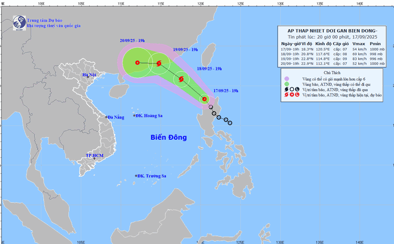
According to the National Center for Hydro-Meteorological Forecasting, at 7:00 a.m. on September 18, the center of the tropical depression was at about 19.8 degrees north latitude, 119 degrees east longitude, in the northeastern sea area of the northern East Sea. The strongest wind near the center of the tropical depression is level 7 (50-61km/h), gusting to level 9. The tropical depression is moving northwest at a speed of about 20km/h.
Mr. Nguyen Van Huong - Head of Weather Forecast Department, National Center for Hydro-Meteorological Forecasting - said that in the next 24 hours, the tropical depression is forecast to move northwest at a speed of 15-20km/h and is likely to strengthen into a storm.

At 7:00 a.m. on September 19, the center of the storm was at about 21.9 degrees north latitude, 116.2 degrees east longitude, in the northern sea area of the northern East Sea. The strongest wind near the storm center is level 8 - 9, gusting to level 11.
The dangerous area in the next 24 hours will be determined to be north of the latitude of 18.5 degrees north latitude and east of the longitude of 115 degrees east longitude. Level 3 natural disaster risk, the affected area is the northeastern sea area of the northern East Sea.
It is forecasted that in the next 48 hours, the storm will continue to move northwest at a speed of about 10 - 15km/h.
At 7:00 a.m. on September 20, the center of the storm was at about 23.2 degrees north latitude, 113.5 degrees east longitude, in the area south of Guangdong province (China). The strongest wind near the storm center is level 8, gusting to level 10.
The dangerous area in the next 48 hours will be identified as the north of the 19.5 km north latitude and within the 113 to 118.5 km east longitude. Level 3 natural disaster risk, the affected area is the northern sea area of the northern East Sea.
It is forecasted that in the next 48 to 72 hours, the storm will move mainly westward, traveling about 10km per hour and gradually weakening.
"Due to the impact of the tropical depression that is likely to strengthen into a storm, from September 18, the northeastern sea area of the northern East Sea will have winds gradually increasing to level 6-7, gusting to level 9. The area near the storm center is strong at level 8 - 9, gusting to level 11, waves 3-5m high, very rough seas" - Mr. Huong warned.
Ship operating in the above-mentioned dangerous areas are likely to be affected by thunderstorms, whirlwinds, strong winds and large waves.
According to data from the meteorological agency, it is forecasted that from now until October 10, 2025, storms and tropical depressions operating in the East Sea and affecting our country are likely to be at a level similar to the average of many years.
According to the average data of many years, in the East Sea during this period, there will be about 2.2 storms or tropical depressions, 1.1 of which will make landfall in Vietnam. Note that there will be storms and tropical depressions appearing right in the East Sea area.
"It is necessary to pay special attention to the possibility of storms and tropical depressions appearing right in the East Sea area" - Mr. Huong said.
Previously, from August 11 to September 10, there were 3 storms and 1 tropical depression in the East Sea.