According to the National Center for Hydro-Meteorological Forecasting, in the past 12 hours (from 8:00 p.m. on September 26 to 8:00 a.m. on September 27), the provinces from Thanh Hoa to Da Nang city have had moderate rain, heavy rain, and very heavy rain in some places. Some monitoring stations have measured heavy rainfall such as: Xuan Le 302.4mm (Thanh Hoa); Thuy Dien Hua Na 288.2mm (Nghe An); Quan Hau 145.4mm (Quang Tri); Ky Lam 80.4mm (Ha Tinh); Ho Truoi 72.8mm (Hue city); Phuoc Ha lake focal point 100mm (Da Nang city);...
Soil moisture models show that some areas in the above provinces are nearly saturated (over 85%) or have reached a saturated state.
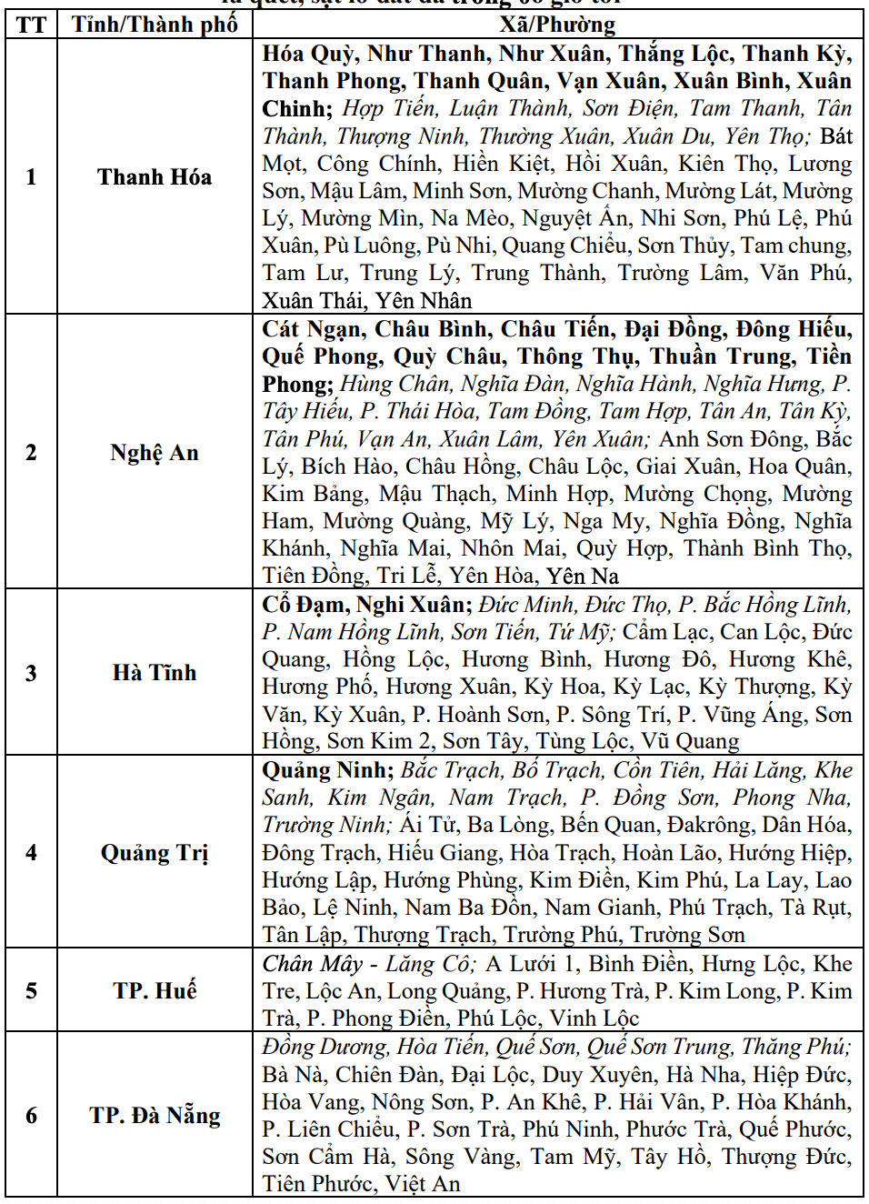
Warning in the next 3 - 6 hours (from 8:40 a.m. on September 27), the above provinces will continue to have rain with accumulated rainfall ranging from 30 - 60mm, some places over 90mm.
Warning in the next 6 hours (from 8:40 a.m. on September 27), there is a risk of flash floods on small rivers and streams, landslides on steep slopes in many communes/wards.
The meteorological agency warns that the risk of natural disasters due to flash floods, landslides, and land subsidence due to heavy rain or water flow is level 1.
The meteorological agency recommends that localities proactively review flow bottlenecks and vulnerable areas to take timely preventive and response measures to the above risks.
Regarding the hydrological situation, currently, the water level on the main rivers of the Red - Thai Binh river system, downstream of the main rivers from Thanh Hoa to Hue city fluctuates and is below alert level 1; the water level on the Dong Nai river at Ta Lai station fluctuates above alert level 1.
From September 27 to October 1, on rivers in the Northern region, from Thanh Hoa to Hue city, there is a possibility of a flood, with a flood amplitude of 5-9 m in the upstream of rivers and 2-5 m in the downstream of rivers.
During this flood, the flood peak on Thao River (Lao Cai), Hoang Long River (Ninh Binh), Buoi River, Ma River, upstream of Chu River (Thanh Hoa), upstream of Ca River (Nghe An), Ngan Sau River, Ngan Pho (Ha Tinh), Kien Giang River (Quang Tri) and small rivers will rise to alert level 2 - alert level 3 and above alert level 3; the flood peak at Hoa Binh Lake (Phu Tho), on Lo River (Tuyen Quang), downstream of Chu River, downstream of Ca River, La River (Ha Tinh), Gianh River, Thach Han River (Quang Tri), Huong River, Bo River (Hue City) will rise to alert level 1 - alert level 2 and above alert level 2; Red River - Thai River in lower alert level 1.
In the next 24 hours (from 9:00 a.m. on September 27), the water level on the Dong Nai River at Ta Lai station will continue to fluctuate according to the operation of the upstream hydropower plant and will be at alert level 1 - alert level 2.
There is a high risk of flooding in low-lying areas along rivers, urban areas in the Northern region, from Thanh Hoa to Hue city; flash floods and landslides on steep slopes in the Northern mountainous areas, from Thanh Hoa to Hue city.
Real-time warning information for areas at risk of flash floods and landslides is provided online on the website of the Department of Hydrometeorology at: https://luquetsatlo.nchmf.gov.vn and in a separate bulletin warning of flash floods and landslides.
The warning level of natural disaster risk due to floods is level 2. Floods on rivers cause flooding in low-lying areas along rivers, affecting activities such as waterway transportation, aquaculture, agricultural production, people's lives and socio-economic activities.