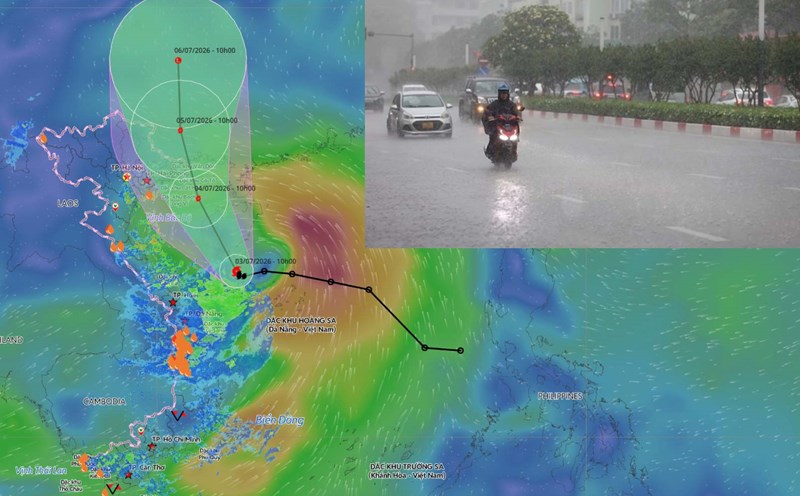
Latest update from the National Center for Hydro-Meteorological Forecasting, at 13:00 on July 3, the center of storm No. 1 was located at about 17.6 degrees North latitude - 109.9 degrees East longitude, about 90km south of Hainan Island (China). The strongest wind near the center of the storm is strong at level 8-9 (62-88 km/h), gusting at level 11.
Storm No. 1 maintains intensity level 8-9 heading towards the Gulf of Tonkin
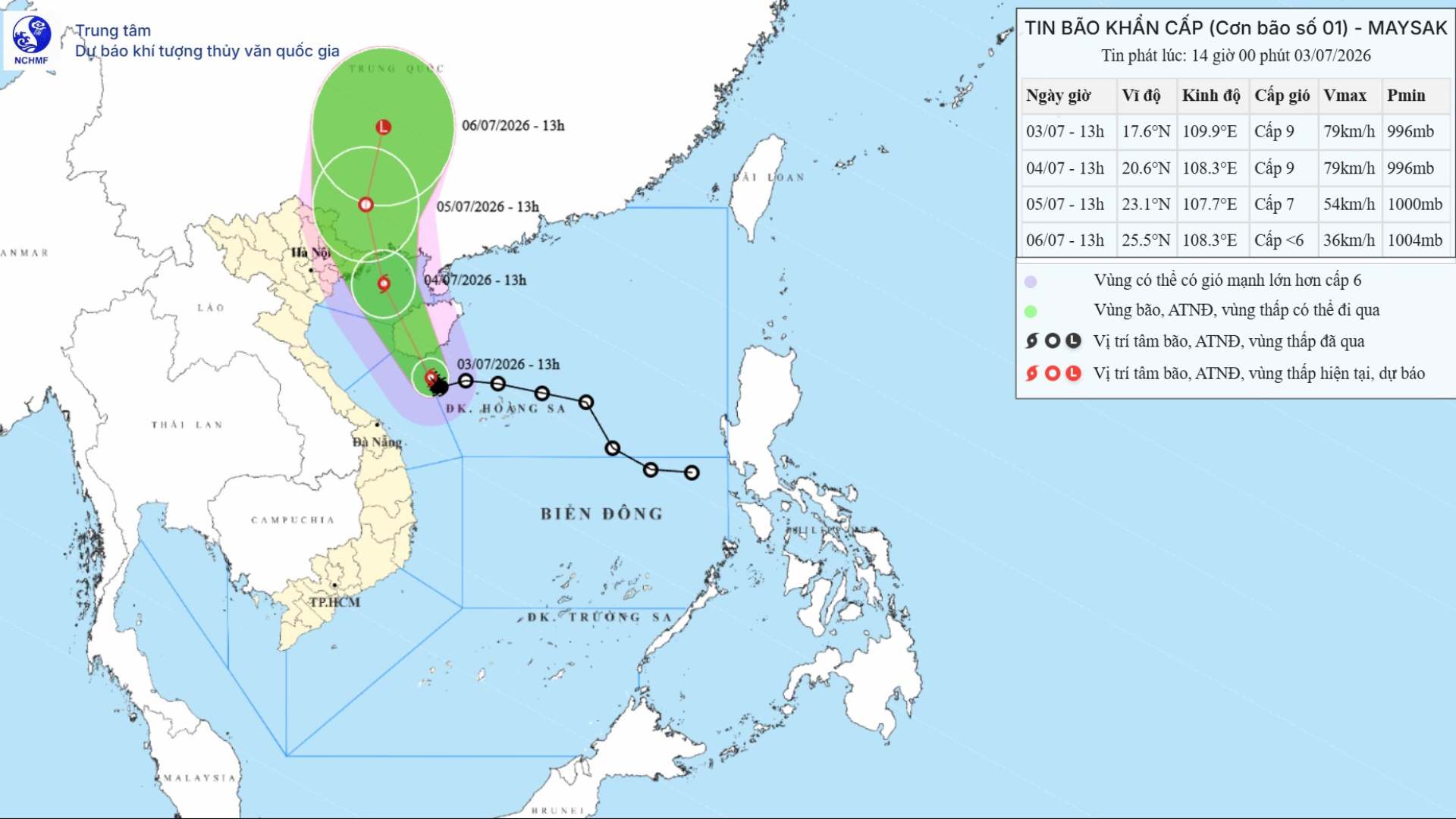
Forecast for the next 24 hours, the storm will move in a North-Northwest direction at a speed of about 15 km/h. By 13:00 on July 4, the storm center will be located at about 20.6 degrees North latitude - 108.3 degrees East longitude; over the Northern Gulf area; about 170km south-southeast of Mong Cai (Quang Ninh). The strongest wind near the storm center is strong at level 8-9, gusting at level 11.
Forecast for the next 48 hours, the storm will move in a North-Northwest direction at a speed of about 10-15 km/h, weakening into a tropical depression. By 1:00 PM on July 5th, the center of the tropical depression will be located at about 23.1 degrees North latitude - 107.7 degrees East longitude; over the southern area of Guangxi province (China). The strongest wind near the center of the tropical depression is strong at level 7, gusting at level 9.
Forecast for the next 72 hours, the tropical depression will move in the North-Northeast direction at a speed of about 10-15km/h, continuing to weaken into a low pressure area below level 6. By 13:00 on July 6, the center of the low pressure area will be located at about 25.5 degrees North latitude - 108.3 degrees East longitude; over the northern area of Guangxi province (China).
Heavy rain from tonight, strong winds on the coast from tomorrow afternoon
Heavy rain on land, the affected areas are Northeast and Thanh Hoa. (In which, the Northeast region includes Hanoi city, Tuyen Quang, Cao Bang, Thai Nguyen, Lang Son, Quang Ninh, Hai Phong city, Bac Ninh, Hung Yen, Ninh Binh, the northern area of Phu Tho province (Vinh Phuc and former Phu Tho provinces)).
Risk from the night of July 3rd to the end of July 5th with heavy to very heavy rain, common rainfall of 100-200mm; especially Northeast of the North 200-300mm, locally over 500mm.
The main impact is that heavy rain can cause flooding in urban areas, industrial parks and low-lying areas; increasing the risk of floods on small rivers and streams, flash floods and landslides in mountainous areas.
Regarding thunderstorms and tornadoes, due to the impact of storm circulation, it is necessary to prevent the risk of thunderstorms, tornadoes and strong gusts of wind both before and during the storm makes landfall.
For the coastal mainland area, the affected area is the coast of Quang Ninh, Hai Phong and Hung Yen provinces.
Risk from the afternoon of July 4, strong wind level 6, near the storm center level 7-8, gusts level 9-10; sea waves 2-3m high; storm surge of about 0.2-0.4m.
The main impact is that strong winds can blow off roofs, damage temporary structures, break down green trees and billboards; affecting electricity, communication and traffic systems. Large waves combined with rising water can cause localized flooding in river mouths, tidal flats and low-lying areas; affecting dikes, seawalls and coastal structures.
For sea activities, the affected area is the sea area west of the Northern East Sea (including the Hoang Sa special zone) and the sea area northeast of the area from South Quang Tri to Quang Ngai; from the night of July 3 expanding to the Gulf of Tonkin (including Bach Long Vy, Van Don, Co To, Cat Hai and Hon Dau island special zones).
Risk of strong winds at level 6-7, near the storm center level 8-9, gusts at level 11; sea waves 2-4m high; very rough seas.