Forecast of heavy rain in the area today July 5 due to storm No. 1 circulation, in some places over 300mm

AN AN |

Due to the circulation of storm No. 1, today July 5, the Northeast region continues to have moderate to heavy rain, with very heavy rain in some places. Quang Ninh coast has strong winds at level 6-7, gusts at level 9-10.

Latest update from the National Center for Hydro-Meteorological Forecasting, due to the influence of storm No. 1's circulation, Bach Long Vi special zone has had strong winds of level 9, gusts of level 11; Co To (Quang Ninh) has strong winds of level 8, gusts of level 10, sea waves 2.25m high; Cua Ong (Quang Ninh) has strong winds of level 8, gusts of level 9; Mong Cai (Quang Ninh) has strong winds of level 9, gusts of level 12; Quang Ha (Quang Ninh) has strong winds of level 8, gusts of level 9.

In the afternoon and night of yesterday (July 4th), Quang Ninh area had heavy to very heavy rain such as Mong Cai monitoring station 247.6mm; Doan Tinh 145.4mm;...

Cập nhật vị trí và đường đi của bão số 1 vào 5h ngày 5.7. Nguồn: Trung tâm Dự báo Khí tượng Thủy văn Quốc gia
Update on the location and path of storm No. 1 at 5:00 AM on July 5. Source: National Center for Hydro-Meteorological Forecasting

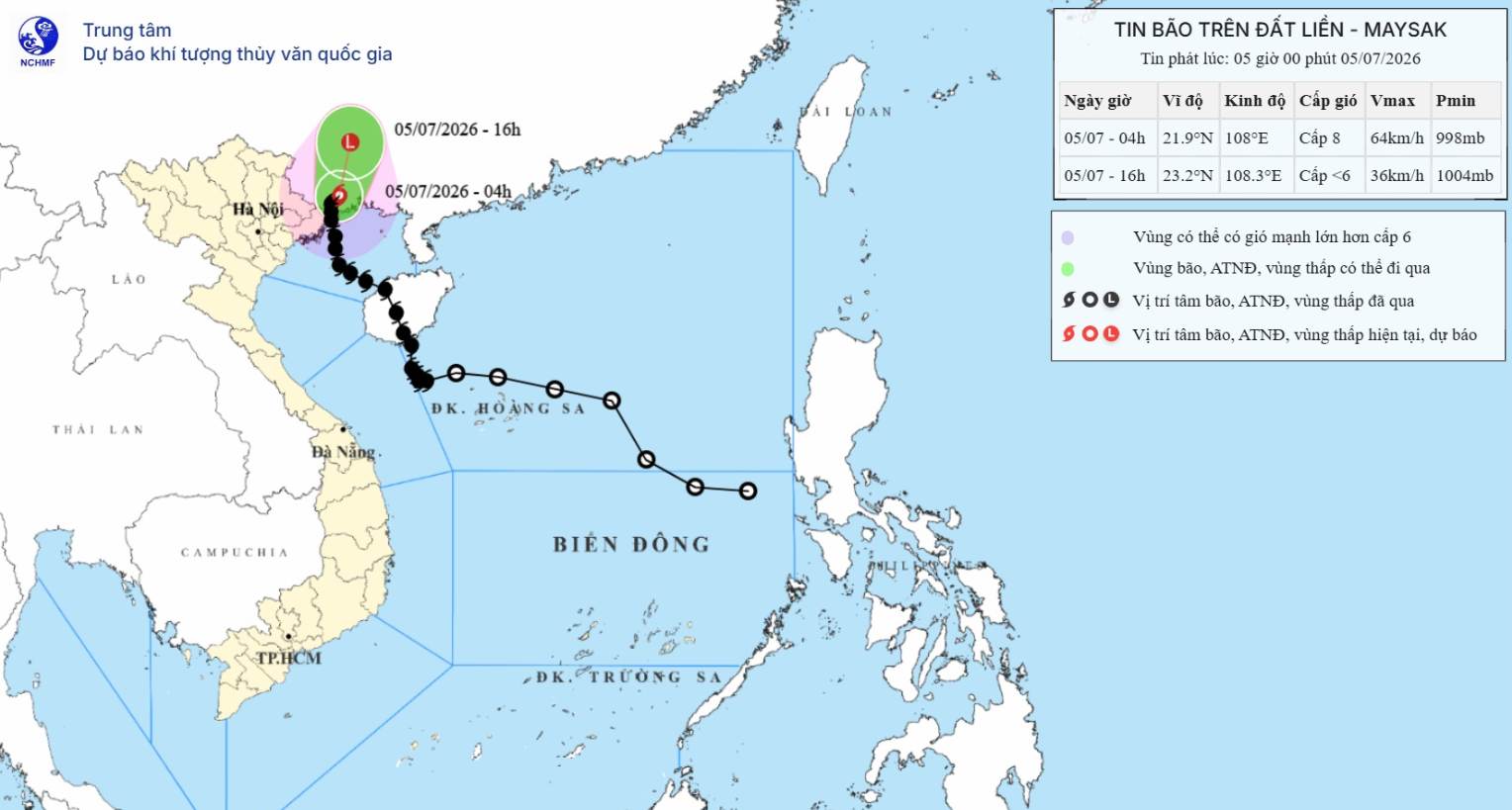
At 4:00 AM on July 5th, the center of storm No. 1 was located at about 21.9 degrees North latitude - 108.0 degrees East longitude, over the southern area of Guangxi province (China). The strongest wind near the center of the storm was strong at level 8 (62 - 74 km/h), gusting at level 10, moving in the North-Northeast direction at a speed of 5-10 km/h.

Forecast for the next 12 hours, the storm will move in a North-Northeast direction at a speed of 10-15 km/h and weaken into a tropical depression, followed by a low pressure area. By 4:00 PM on July 5th, the center of the low pressure area will be located at about 23.2 degrees North latitude - 108.3 degrees East longitude; over the southern area of Guangxi province (China). Intensity will decrease to below level 6.

Regarding heavy rain, the affected area is the Northeast region.

Risk from early morning to the end of July 5th with moderate to heavy rain, common rainfall of 40-90mm, locally over 120mm; especially the Northeast region has heavy to very heavy rain with common rainfall of 100-200mm, locally over 300mm.

Heavy rain may cause flooding in urban areas, industrial parks and low-lying areas; increasing the risk of floods on small rivers and streams, flash floods and landslides in mountainous areas.

The coastal mainland and coastal areas of Quang Ninh province are affected.

Risk of strong winds at level 6-7, gusts at level 9-10.

Strong winds can blow off roofs, damage temporary structures, break down green trees, billboards; affect electrical, telecommunications and transportation systems.

At sea, the affected area is the North of the Gulf of Tonkin (including Bach Long Vi, Van Don, Co To, Cat Hai special zones).

Risk of strong winds at level 6-7, gusts at level 9-10; sea waves 2-3m high; strong rough seas.

Dangerous weather conditions can cause capsizing, sinking or damage to fishing boats, transport boats, tourist boats and vehicles operating at sea; aquaculture cages, boat anchorage areas and coastal works are at risk of being damaged. Seafood exploitation, transportation and tourism activities at sea are likely to be interrupted.

AN AN
RELATED NEWS

Typhoon No. 1 just made landfall in Quang Ninh, gusting at level 11 - 12, causing heavy rain and strong winds

|

The meteorological agency has just announced that storm No. 1 has made landfall in Quang Ninh with intensity level 8 - 9, gusts level 11 - 12.

Warning of 4 provinces and cities with the heaviest rain from tonight to tomorrow morning due to storm No. 1

|

From tonight to tomorrow morning, the Northeast region (mainly Quang Ninh, Hai Phong, Lang Son, Bac Ninh) will have heavy to very heavy rain due to the impact of storm No. 1.

Storm No. 1 enters the coast of Quang Ninh, the heaviest rain from tonight to tomorrow morning

|

This afternoon, July 4th, storm No. 1 has entered the coast of Quang Ninh. Forecast of the strongest wind is from now until 9 pm, heavy rain concentrated from tonight to tomorrow morning.

Older brother overcomes a thousand thorns shining until 2 am, the results are controversial

|

Episode 2 of "Anh Trai Vuot Ngan Chong Gai" season 2 created a lively debate after 10 groups performed the first performances.

Infrastructure accelerates but site clearance is still congested at VSIP Can Tho industrial park

|

Can Tho - Vinh Thanh Industrial Park Project (phase 1) achieved many results in infrastructure construction, but still faced difficulties in site clearance and procedures.

Hero Ngo Thi Tuyen passed away at the age of 80

|

Thanh Hoa - Hero Ngo Thi Tuyen, who carried 2 boxes of ammunition heavier than twice her body weight during the anti-American resistance war, has passed away.

Typhoon No. 1 just made landfall in Quang Ninh, gusting at level 11 - 12, causing heavy rain and strong winds

AN AN |

The meteorological agency has just announced that storm No. 1 has made landfall in Quang Ninh with intensity level 8 - 9, gusts level 11 - 12.

Warning of 4 provinces and cities with the heaviest rain from tonight to tomorrow morning due to storm No. 1

AN AN |

From tonight to tomorrow morning, the Northeast region (mainly Quang Ninh, Hai Phong, Lang Son, Bac Ninh) will have heavy to very heavy rain due to the impact of storm No. 1.

Storm No. 1 enters the coast of Quang Ninh, the heaviest rain from tonight to tomorrow morning

AN AN |

This afternoon, July 4th, storm No. 1 has entered the coast of Quang Ninh. Forecast of the strongest wind is from now until 9 pm, heavy rain concentrated from tonight to tomorrow morning.