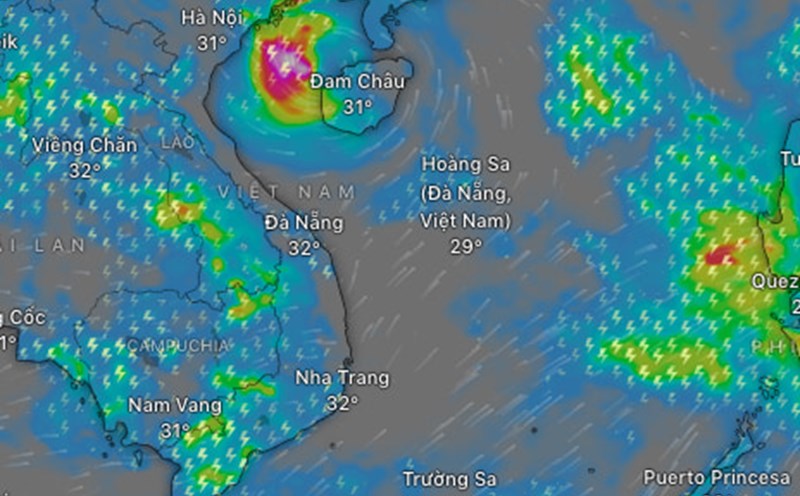
Latest update from the National Center for Hydro-Meteorological Forecasting, at 4:00 p.m. on July 21, the center of storm No. 2 is at about 17.4 degrees north latitude; 110.9 degrees east longitude, in the northwest sea of Hoang Sa archipelago, about 180km southeast of Hainan island (China).
The strongest wind near the center of the storm is level 8 (62-74km/h), with gusts of level 10, moving in the west-northwest direction at a speed of 10-15km/h.
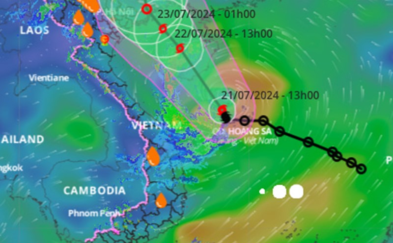
It is forecast that in the next 24 hours , storm No. 2 will move northwest at a speed of about 15 km/h into the Gulf of Tonkin. By 4:00 p.m. on July 22, the storm's center was located at about 20.1 degrees north latitude - 108.9 degrees east longitude; in the eastern waters of the Gulf of Tonkin.
The strongest wind near the center of the storm is level 8, with gusts of level 10.
Storm danger zone No. 2 in the next 24 hours is from 16 - 21.5 degrees north latitude; 107 - 112.5 degrees east longitude.
In the next 48 hours , storm No. 2 moves northwest at a speed of about 10 km/h and weakens into a tropical depression. By 4:00 p.m. on July 23, the tropical depression's center was located at about 21.7 degrees north latitude - 107.7 degrees east longitude; on the southern mainland of Guangxi province (China).
The strongest winds near the center of the tropical depression are strong at level 6, with gusts at level 8.
The danger zone in the next 48 hours is north of 18.5 degrees north latitude; west of the 110th meridian.
In the next 72 hours , the tropical depression will still move northwest at a speed of about 5 km/h and gradually weaken into a low pressure area. At 4:00 p.m. on July 24, the center of the low pressure area on the mainland of southern Guangxi province was located.
Regarding the impact of storm No. 2 , the western sea area of the North East Sea (including the Hoang Sa archipelago), the eastern sea area of Quang Tri to Quang Ngai area and the eastern sea area of the Southern Gulf of Tonkin have strong winds. 6 - 7, rough seas. Sea waves are 2 - 4m high, near the center of the storm 3 - 5m.
Since the morning of July 22, the northern waters of the Gulf of Tonkin (including Bach Long Vi and Co To islands) have had winds gradually increasing to level 6 - 7, the area near the center of the storm passing through is strong at level 8, with gusts at level 10, and rough seas. Waves gradually increase to 2 - 4m/
Since the morning of July 23, the coastal area of Quang Ninh province is likely to be affected by strong winds of level 6 and gusts of level 8; Waves are 1.5 - 2.5m high.
On the mainland, from the night of July 22 to July 24, the Northern region and Thanh Hoa are warned that there is a possibility of moderate rain, heavy rain and thunderstorms, with some places having very heavy rain.