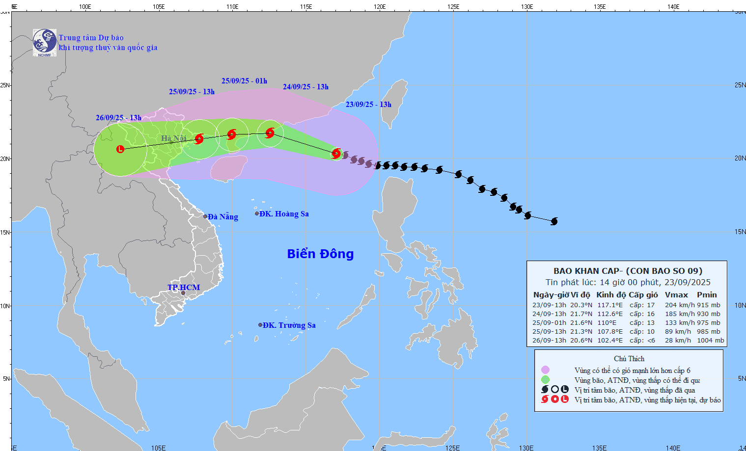
According to the National Center for Hydro-Meteorological Forecasting, at 1:00 p.m. on September 23, the center of super typhoon No. 9 Ragasa was located in the northeastern sea of the northern East Sea. The strongest wind intensity near the center of the super typhoon is tending to weaken, strong at level 16-17 (184-221km/h), gusting above level 17.
This afternoon, September 23, Mr. Mai Van Khiem - Director of the National Center for Hydro-Meteorological Forecasting provided new comments on the development of this storm.

Storm makes landfall in Quang Ninh - Hung Yen from noon to afternoon on September 25
Sir, what are the notable characteristics of super typhoon No. 9 Ragasa and when is the typhoon forecast to make landfall in Vietnam?
- Typhoon Ragasa is considered the strongest super typhoon in the world in 2025 to date, surpassing both Typhoon Erin (North Atlantic) and Typhoon Yagi (in 2024). The storm's speed is fast, about 20-25km/h.
The storm's circulation is wide with a strong wind zone of level 6 with a radius of about 450km, a strong wind zone of level 10 with about 200km around the eye of the storm, and a strong wind zone of level 12 with about 100km around the eye of the storm.
As of 1:00 p.m. on September 23, the forecast of international and Vietnamese storm forecasting centers was highly unified in the direction of movement. The super typhoon is expected to reach the coastal area of Guangdong province (China), then turn west, pass through the northern area of Zhou Peninsula (China), along the northern coast of the Gulf of Tonkin.
At around noon to the afternoon of September 25, the storm center will make landfall in our country; the area from Quang Ninh - Hung Yen is the area with a high possibility of the storm center making landfall.
When approaching the Gulf of Tonkin, will super typhoon No. 9 reduce in intensity as previously forecast, sir?
- In terms of intensity, storm No. 9 will continue to maintain a strong intensity of level 15-16 from now until the morning of September 24. From the morning of September 24, when moving to the southern sea of Guangdong province (China), there will be friction with the terrain, plus the dry air of cold air from the north will move down, penetrating the storm center, the storm intensity will decrease, from level 16 to level 11 - 12 when moving into the Gulf of Tonkin.
The level of degradation is also in line with international forecasts.
Uneven distribution of rain due to storm No. 9
Sir, now that storm No. 9 is heading towards the North, which area is forecast to be the focus of heavy rain in the coming days?
- From the night of September 24 to September 26, in the Northern region, Thanh Hoa and Nghe An, there will be heavy to very heavy rain with common rainfall of 100-250mm, locally over 400mm.
Heavy rain will be concentrated in the provinces of Thai Nguyen, Southern Tuyen Quang, Lao Cai, Phu Tho, the Northern Delta, Thanh Hoa.
The distribution of rain over time is not uniform. On September 25, the rain will be concentrated in Cao Bang, Thai Nguyen, Lang Son, Quang Ninh, Hai Phong, Bac Ninh, Hung Yen; on September 26-27, the rain will occur in Phu Tho, the Northern Delta, Thanh Hoa.
With such a heavy rain, what could be the consequences of natural disasters, can you warn?
- Due to heavy rain, it is forecasted that there will be a flood on rivers in the Northern region, from Thanh Hoa and Nghe An, with the flood peaks on rivers likely as follows.
In the North, Thao River, Lo River, upstream of Thai Binh River, Hoang Long River will rise to alert level 1 - alert level 2 and above alert level 2; downstream of Red River, Thai Binh will still be below alert level 1. On small rivers, it will be raised to alert level 2 - alert level 3.
In Thanh Hoa, Buoi River, upstream of Ma River, Chu to alert level 1 - alert level 2 and above alert level 2; downstream of Ma River to alert level 1.
In Nghe An, the upstream of Ca River will be at alert level 1 - alert level 2 and above alert level 2; the downstream of Ca River will be at alert level 1.
There is a high risk of flooding in low-lying areas along rivers, urban areas, and densely populated areas. Heavy rain, concentrated in a short period of time, is a special risk of flash floods and landslides, concentrated in the mountainous and midland areas of the North, Thanh Hoa and Nghe An, from September 25 to September 27.
Sincerely thank you!