The National Center for Hydro-Meteorological Forecasting has issued a forecast of notable weather trends in the next month (ie from now until November 10).
2 - 3 storms/tropical depressions appear in the East Sea
In the next month, the most notable weather patterns will still be storms/tropical depressions and storm rain.
According to Ms. Tran Thi Chuc - Deputy Head of Climate Forecasting Department, National Center for Hydro-Meteorological Forecasting, according to the average data of many years in the above period, there were 1.8 storms or tropical depressions in the East Sea, 0.8 of which made landfall in Vietnam.
From now until November 10, 2025, it is forecasted that there will be 2 - 3 storms or tropical depressions in the East Sea and 1 - 2 storms will likely affect the mainland of Vietnam.

According to Dr. Truong Ba Kien - Deputy Director of the Center for Meteorological and Climate Research - Institute of Meteorology, Hydrology and Climate Change - from now until the end of 2025, tropical cyclone activity in the East Sea will be at a level close to the average of many years, i.e. about 3 - 4 storms and tropical depressions.
"The main affected area is likely to be the Central region, especially in October and the first half of November, when storm activity often peaks at the end of the season" - Dr. Kien commented.
Previously, from September 11 to October 10, there were 4 storms in the East Sea, including storm No. 8 Mitag, storm No. 9 Ragasa, storm No. 10 Bualoi and storm No. 11 Matmo. Of which, storms No. 9, No. 10 and No. 11 have directly affected our country.
Data analyzed by the meteorological agency also shows that in the next month, the total rainfall in the regions will generally be approximately the same as the average of many years. In particular, the provinces from Ha Tinh to Quang Ngai have total rainfall generally 20 - 40% higher than the average of many years in the same period.
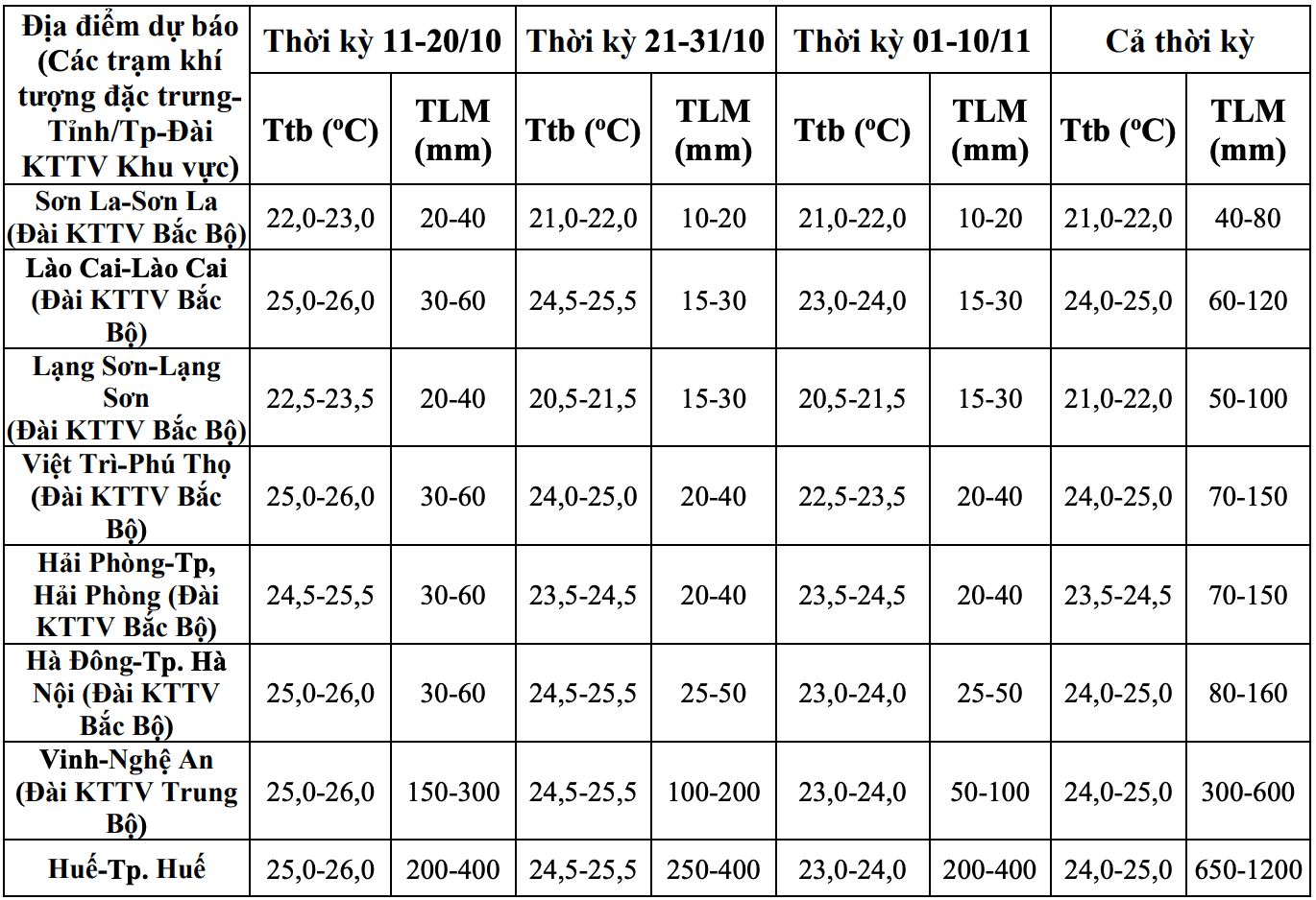

From now until November 10, it is forecasted that there will be widespread heavy rain in the early stages in the Northern region and Thanh Hoa and Nghe An provinces. The provinces from Ha Tinh to Quang Ngai are likely to experience some widespread heavy rains. Other areas will have many days of showers and thunderstorms; some days may have moderate to heavy rain.
Cold air gradually strengthens from mid to late October
Regarding temperature trends, during the forecast period, the average temperature in the Northern region and Thanh Hoa - Hue provinces will be approximately the same as the average of many years, other areas will be 0.5 - 1 degree Celsius higher than the average of many years in the same period.
Ms. Tran Thi Chuc added that cold air tends to be active and increase in frequency and intensity over the next month.
According to Dr. Truong Ba Kien, currently, atmospheric and ocean conditions reflect that ENSO is in a neutral state, leaning towards the cold phase. ENSO is forecast to likely transition to La Nina state in the last 3 months of 2025 with a fairly high probability - about 60 - 70%.
"The winter wind is likely to start at the same level as the average of many years (ie at the end of October) and increase in intensity from November" - Mr. Kien said.