The Philippine Atmospheric, Geophysical and Astronomical Services Administration (PAGASA) said that on the afternoon of December 23, tropical depression Romina strengthened into storm Pabuk, outside the Philippine Forecast Area (PAR).
At 3:00 p.m. on December 23, the center of the storm was at about 10.9 degrees north latitude, 112.8 degrees east longitude, 165 km west of Kalayaan, Palawan (Philippines). Maximum winds near the center of the storm are 65 km/h, gusting to 80 km/h. The storm moved slowly south.
Although the storm has moved away from PAR, it still caused thunderstorms in Eastern Visayas, Bicol, Metro Manila, Cagayan Valley, Cordillera Administrative Region, Aurora, Bulacan, Nueva Ecija, with the risk of flash floods and landslides.
The storm forecast bulletin of the Vietnam National Center for Hydro-Meteorological Forecasting said that storm Pabuk is the 10th storm in 2024. The storm is currently in the northwest area of Truong Sa archipelago.
It is forecasted that by 1:00 p.m. on December 24, the center of storm No. 10 will be at about 11.4 degrees north latitude, 111.2 degrees east longitude, in the southwestern sea area of the central East Sea.
The strongest wind near the center of the storm is level 8, gusting to level 10, moving in the west-northwest direction, traveling 5-10 km per hour. Level 3 natural disaster risk in the northern part of the southern East Sea (including the northern part of Truong Sa archipelago), the sea area southwest of the central East Sea.
It is forecasted that by 1:00 p.m. on December 25, the center of storm No. 10 will be at about 10.9 degrees north latitude, 109.6 degrees east longitude, in the sea from Phu Yen to Ba Ria-Vung Tau. The strongest wind near the center of the storm is level 6, gusting to level 8, moving west-southwest, traveling 5-10 km per hour and gradually weakening into a tropical depression. Level 3 natural disaster risk in the sea area from Phu Yen to Ba Ria-Vung Tau; the sea area southwest of the central East Sea, the sea area northwest of the southern East Sea (including the northwest area of Truong Sa archipelago).
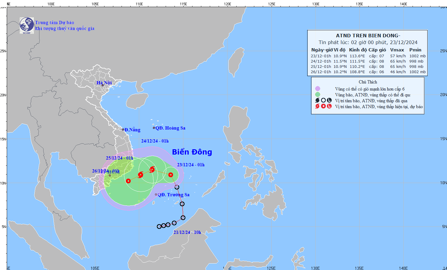
It is expected that by 1:00 a.m. on December 26, the tropical depression will gradually weaken over the sea from Binh Thuan to Tra Vinh, with winds below level 6.
Due to the impact of storm No. 10, the sea area north of the southern South China Sea (including the northern part of Truong Sa archipelago) and the sea area southwest of the central East Sea will have strong winds of level 6-7, the area near the storm's center will have strong winds of level 8, gusts of level 10, waves 4-6m high; rough seas.
Ship operating in the above-mentioned dangerous areas are likely to be affected by thunderstorms, whirlwinds, strong winds, and large waves.


